

transport. In microtidal areas, flood deltas are often better
developed than their ebb counterparts, owing to the
dominance of landward, wave-driven, sediment transport.
Ebb delta morphology is generally more variable than that
of flood deltas, owing to the importance of regional and
local contrasts in wave climate (Boothroyd, 1985) and
due to the close coupling of delta processes with wider
coastal morphodynamics. Ebb delta volume increases
with the tidal prism and decreases with inlet width/depth
ratio and wave energy. Under conditions of low wave
energy, ebb deltas are typically more elongated and extend
farther seaward.
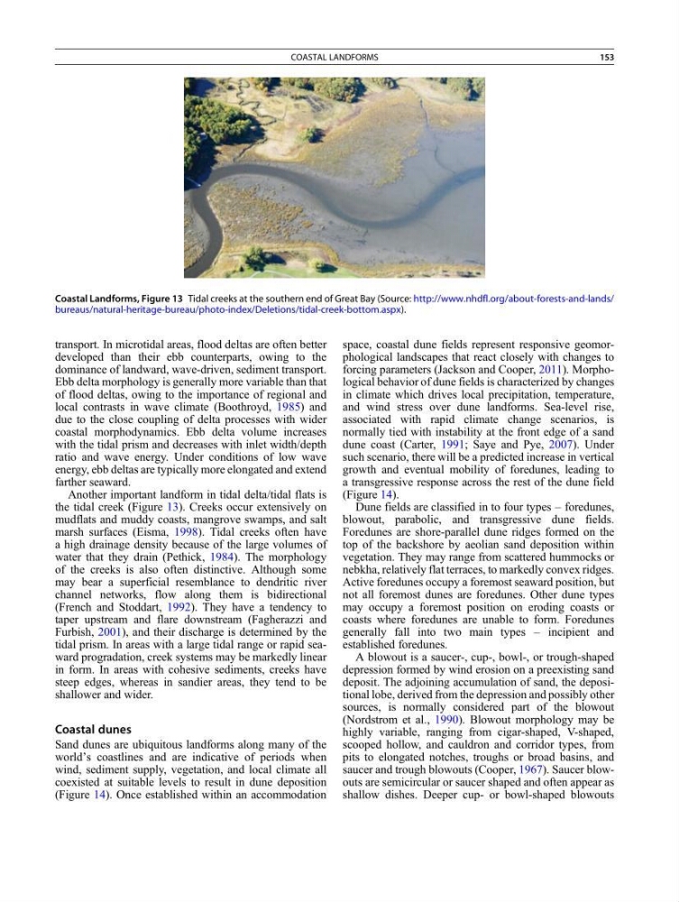
Another important landform in tidal delta/tidal flats is
the tidal creek (Figure 13). Creeks occur extensively on
mudflats and muddy coasts, mangrove swamps, and salt
marsh surfaces (Eisma, 1998). Tidal creeks often have
a high drainage density because of the large volumes of
water that they drain (Pethick, 1984). The morphology
of the creeks is also often distinctive. Although some
may bear a superficial resemblance to dendritic river
channel networks, flow along them is bidirectional
(French and Stoddart, 1992). They have a tendency to
taper upstream and flare downstream (Fagherazzi and
Furbish, 2001), and their discharge is determined by the
tidal prism. In areas with a large tidal range or rapid seaward progradation, creek systems may be markedly linear
in form. In areas with cohesive sediments, creeks have
steep edges, whereas in sandier areas, they tend to be
shallower and wider.
Coastal dunes
Sand dunes are ubiquitous landforms along many of the
world’s coastlines and are indicative of periods when
wind, sediment supply, vegetation, and local climate all
coexisted at suitable levels to result in dune deposition
(Figure 14). Once established within an accommodation
space, coastal dune fields represent responsive geomorphological landscapes that react closely with changes to
forcing parameters (Jackson and Cooper, 2011). Morphological behavior of dune fields is characterized by changes
in climate which drives local precipitation, temperature,
and wind stress over dune landforms. Sea-level rise,
associated with rapid climate change scenarios, is
normally tied with instability at the front edge of a sand
dune coast (Carter, 1991; Saye and Pye, 2007). Under
such scenario, there will be a predicted increase in vertical
growth and eventual mobility of foredunes, leading to
a transgressive response across the rest of the dune field
(Figure 14).
Dune fields are classified in to four types – foredunes,
blowout, parabolic, and transgressive dune fields.
Foredunes are shore-parallel dune ridges formed on the
top of the backshore by aeolian sand deposition within
vegetation. They may range from scattered hummocks or
nebkha, relatively flat terraces, to markedly convex ridges.
Active foredunes occupy a foremost seaward position, but
not all foremost dunes are foredunes. Other dune types
may occupy a foremost position on eroding coasts or
coasts where foredunes are unable to form. Foredunes
generally fall into two main types – incipient and
established foredunes.
A blowout is a saucer-, cup-, bowl-, or trough-shaped
depression formed by wind erosion on a preexisting sand
deposit. The adjoining accumulation of sand, the depositional lobe, derived from the depression and possibly other
sources, is normally considered part of the blowout
(Nordstrom et al., 1990). Blowout morphology may be
highly variable, ranging from cigar-shaped, V-shaped,
scooped hollow, and cauldron and corridor types, from
pits to elongated notches, troughs or broad basins, and
saucer and trough blowouts (Cooper, 1967). Saucer blowouts are semicircular or saucer shaped and often appear as
shallow dishes. Deeper cup- or bowl-shaped blowouts
Coastal Landforms, Figure 13 Tidal creeks at the southern end of Great Bay (Source: http://www.nhdfl.org/about-forests-and-lands/
bureaus/natural-heritage-bureau/photo-index/Deletions/tidal-creek-bottom.aspx).
COASTAL LANDFORMS
153
developed than their ebb counterparts, owing to the
dominance of landward, wave-driven, sediment transport.
Ebb delta morphology is generally more variable than that
of flood deltas, owing to the importance of regional and
local contrasts in wave climate (Boothroyd, 1985) and
due to the close coupling of delta processes with wider
coastal morphodynamics. Ebb delta volume increases
with the tidal prism and decreases with inlet width/depth
ratio and wave energy. Under conditions of low wave
energy, ebb deltas are typically more elongated and extend
farther seaward.
Another important landform in tidal delta/tidal flats is
the tidal creek (Figure 13). Creeks occur extensively on
mudflats and muddy coasts, mangrove swamps, and salt
marsh surfaces (Eisma, 1998). Tidal creeks often have
a high drainage density because of the large volumes of
water that they drain (Pethick, 1984). The morphology
of the creeks is also often distinctive. Although some
may bear a superficial resemblance to dendritic river
channel networks, flow along them is bidirectional
(French and Stoddart, 1992). They have a tendency to
taper upstream and flare downstream (Fagherazzi and
Furbish, 2001), and their discharge is determined by the
tidal prism. In areas with a large tidal range or rapid seaward progradation, creek systems may be markedly linear
in form. In areas with cohesive sediments, creeks have
steep edges, whereas in sandier areas, they tend to be
shallower and wider.
Coastal dunes
Sand dunes are ubiquitous landforms along many of the
world’s coastlines and are indicative of periods when
wind, sediment supply, vegetation, and local climate all
coexisted at suitable levels to result in dune deposition
(Figure 14). Once established within an accommodation
space, coastal dune fields represent responsive geomorphological landscapes that react closely with changes to
forcing parameters (Jackson and Cooper, 2011). Morphological behavior of dune fields is characterized by changes
in climate which drives local precipitation, temperature,
and wind stress over dune landforms. Sea-level rise,
associated with rapid climate change scenarios, is
normally tied with instability at the front edge of a sand
dune coast (Carter, 1991; Saye and Pye, 2007). Under
such scenario, there will be a predicted increase in vertical
growth and eventual mobility of foredunes, leading to
a transgressive response across the rest of the dune field
(Figure 14).
Dune fields are classified in to four types – foredunes,
blowout, parabolic, and transgressive dune fields.
Foredunes are shore-parallel dune ridges formed on the
top of the backshore by aeolian sand deposition within
vegetation. They may range from scattered hummocks or
nebkha, relatively flat terraces, to markedly convex ridges.
Active foredunes occupy a foremost seaward position, but
not all foremost dunes are foredunes. Other dune types
may occupy a foremost position on eroding coasts or
coasts where foredunes are unable to form. Foredunes
generally fall into two main types – incipient and
established foredunes.
A blowout is a saucer-, cup-, bowl-, or trough-shaped
depression formed by wind erosion on a preexisting sand
deposit. The adjoining accumulation of sand, the depositional lobe, derived from the depression and possibly other
sources, is normally considered part of the blowout
(Nordstrom et al., 1990). Blowout morphology may be
highly variable, ranging from cigar-shaped, V-shaped,
scooped hollow, and cauldron and corridor types, from
pits to elongated notches, troughs or broad basins, and
saucer and trough blowouts (Cooper, 1967). Saucer blowouts are semicircular or saucer shaped and often appear as
shallow dishes. Deeper cup- or bowl-shaped blowouts
Coastal Landforms, Figure 13 Tidal creeks at the southern end of Great Bay (Source: http://www.nhdfl.org/about-forests-and-lands/
bureaus/natural-heritage-bureau/photo-index/Deletions/tidal-creek-bottom.aspx).
COASTAL LANDFORMS
153