

proportion related to wave-generated currents. As most of
the sediment for the spit platform is supplied by longshore
transport, it mimics sediment availability to the superstructure, though tending toward finer sediment
(Ollerhead and Davidson-Arnott, 1995).
The spit platform requires an increasing sediment
volume as the spit progressively builds into deeper water
and as the volume of the superstructure generally remains
the same. Spit elongation rates will decline over time if the
longshore sediment supply rate does not increase. Thus,
sediment supply rate is a major control on spit development. Rapid wave shoaling and landward curvature of
the breaking wave crest at the spit terminus with steep
bathymetric gradients lead to curvature of the distal
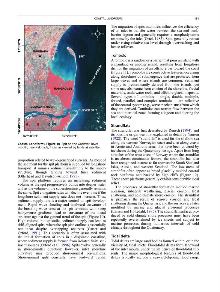
structure against the general trend of the spit (Figure 10).
High volume, but episodic, sediment supply can lead to
drift-aligned spits, where the spit plan outline is essentially
rectilinear despite overlapping recurves (Carter and
Orford, 1991). This scenario is often associated with
the initial formation of spits in a disjointed coastline,
where sediment supply is formed from isolated finite sediment sources (Orford et al., 1996). Spits evolve generally
in shore-parallel direction; however, inlet shoreline
curvature may produce shore-normal orientations.
Shore-normal spits generally have landward trends.
The migration of spits into inlets influences the efficiency
of an inlet to transfer water between the sea and backbarrier lagoon and generally requires a morphodynamic
response by the inlet (Ortel, 1985). Spits generally retreat
under rising relative sea level through overwashing and
hence rollover.
Tombolo
A tombolo is a sandbar or a barrier that joins an island with
a mainland or another island, resulting from longshore
drift or the migration of an offshore bar toward the coast
(Figure 11). Tombolos are constructive features, occurring
along shorelines of submergence that are protected from
large waves and where islands are common. Sediment
supply is predominantly derived from the islands, yet
some may also come from erosion of the shoreline, fluvial
materials, underwater reefs, and offshore glacial deposits.
Several types of tombolos – single, double, multiple,
forked, parallel, and complex tombolos – are reflective
of the coastal system (e.g., wave mechanisms) from which
they are derived. Tombolos can restrict flow between the
sea and intertidal zone, forming a lagoon and altering the
local ecology.
Strandflats
The strandflat was first described by Reusch (1894), and
its possible origin was first explained in detail by Nansen
(1922). The word “strandflat” is used for the shallow sea
along the western Norwegian coast and also along coasts
in Arctic and Antarctic areas that have been covered by
ice sheets during the Quaternary ice age. Apart from long
stretches of the west coast of Norway where the strandflat
is an almost continuous feature, the strandflat has also
been recognized in areas as far apart as the South Shetland
Isles, Alaska, and western Scotland. The low areas of
strandflat often appear as broad glacially molded coastal
rock platforms and backed by high cliffs (Figure 12).
These shore platforms generally exhibit considerable local
relief.
The processes of strandflat formation include marine
abrasion, subaerial weathering, glacial erosion, frost
shattering, and cold climate shore erosion. The strandflat
is primarily the result of sea-ice erosion and frost
shattering during the Quaternary, and the surfaces are later
modified by marine and glacial erosional processes
(Larsen and Holtedahl, 1985). The strandflat surfaces produced by cold climate shore processes must have been
repeatedly overwhelmed by ice sheets and subject to
marine processes during numerous intervals of cold
climate throughout the Quaternary.
Tidal delta
Tidal deltas are large sand bodies formed within, or in the
vicinity of, tidal inlets. Flood-tidal deltas form landward
of the inlet mouth, under the influence of flood-tidal currents. The major morphological features of flood-tidal
deltas typically include a seaward-dipping flood ramp.
Coastal Landforms, Figure 10 Spit on the Godavari River
mouth, near Kakinada, India, as viewed by lands at satellite.
COASTAL LANDFORMS
151
the sediment for the spit platform is supplied by longshore
transport, it mimics sediment availability to the superstructure, though tending toward finer sediment
(Ollerhead and Davidson-Arnott, 1995).
The spit platform requires an increasing sediment
volume as the spit progressively builds into deeper water
and as the volume of the superstructure generally remains
the same. Spit elongation rates will decline over time if the
longshore sediment supply rate does not increase. Thus,
sediment supply rate is a major control on spit development. Rapid wave shoaling and landward curvature of
the breaking wave crest at the spit terminus with steep
bathymetric gradients lead to curvature of the distal
structure against the general trend of the spit (Figure 10).
High volume, but episodic, sediment supply can lead to
drift-aligned spits, where the spit plan outline is essentially
rectilinear despite overlapping recurves (Carter and
Orford, 1991). This scenario is often associated with
the initial formation of spits in a disjointed coastline,
where sediment supply is formed from isolated finite sediment sources (Orford et al., 1996). Spits evolve generally
in shore-parallel direction; however, inlet shoreline
curvature may produce shore-normal orientations.
Shore-normal spits generally have landward trends.
The migration of spits into inlets influences the efficiency
of an inlet to transfer water between the sea and backbarrier lagoon and generally requires a morphodynamic
response by the inlet (Ortel, 1985). Spits generally retreat
under rising relative sea level through overwashing and
hence rollover.
Tombolo
A tombolo is a sandbar or a barrier that joins an island with
a mainland or another island, resulting from longshore
drift or the migration of an offshore bar toward the coast
(Figure 11). Tombolos are constructive features, occurring
along shorelines of submergence that are protected from
large waves and where islands are common. Sediment
supply is predominantly derived from the islands, yet
some may also come from erosion of the shoreline, fluvial
materials, underwater reefs, and offshore glacial deposits.
Several types of tombolos – single, double, multiple,
forked, parallel, and complex tombolos – are reflective
of the coastal system (e.g., wave mechanisms) from which
they are derived. Tombolos can restrict flow between the
sea and intertidal zone, forming a lagoon and altering the
local ecology.
Strandflats
The strandflat was first described by Reusch (1894), and
its possible origin was first explained in detail by Nansen
(1922). The word “strandflat” is used for the shallow sea
along the western Norwegian coast and also along coasts
in Arctic and Antarctic areas that have been covered by
ice sheets during the Quaternary ice age. Apart from long
stretches of the west coast of Norway where the strandflat
is an almost continuous feature, the strandflat has also
been recognized in areas as far apart as the South Shetland
Isles, Alaska, and western Scotland. The low areas of
strandflat often appear as broad glacially molded coastal
rock platforms and backed by high cliffs (Figure 12).
These shore platforms generally exhibit considerable local
relief.
The processes of strandflat formation include marine
abrasion, subaerial weathering, glacial erosion, frost
shattering, and cold climate shore erosion. The strandflat
is primarily the result of sea-ice erosion and frost
shattering during the Quaternary, and the surfaces are later
modified by marine and glacial erosional processes
(Larsen and Holtedahl, 1985). The strandflat surfaces produced by cold climate shore processes must have been
repeatedly overwhelmed by ice sheets and subject to
marine processes during numerous intervals of cold
climate throughout the Quaternary.
Tidal delta
Tidal deltas are large sand bodies formed within, or in the
vicinity of, tidal inlets. Flood-tidal deltas form landward
of the inlet mouth, under the influence of flood-tidal currents. The major morphological features of flood-tidal
deltas typically include a seaward-dipping flood ramp.
Coastal Landforms, Figure 10 Spit on the Godavari River
mouth, near Kakinada, India, as viewed by lands at satellite.
COASTAL LANDFORMS
151