

4 NORDERGRij NOE _ N
- -- -- 10m - DEPTH
o
10 Kt0<4
OElMEN HOR $T
...
' "
o .;.
~ '"
.. 0
" on:r ,
o on
gO'
o
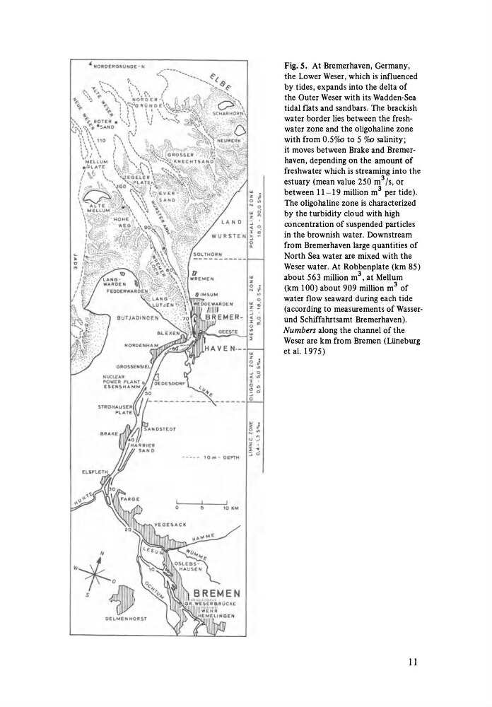
Fig.5. At Bremerhaven, Germany,
the Lower Weser, which is influenced
by tides, expands into the delta of
the Outer Weser with its Wadden-Sea
tidal flats and sandbars. The brackish
water border lies between the freshwater zone and the oligohaline zone
with from 0.50/aJ to 5 o/aJ salinity;
it moves between Brake and Bremerhaven, depending on the amount of
freshwater which is streaming into the
estuary (mean value 250 m 3 Is, or
between 11-19 million m 3 per tide).
The oligohaline zone is characterized
by the turbidity cloud with high
concentration of suspended particles
in the brownish water. Downstream
from Bremerhaven large quantities of
North Sea water are mixed with the
Weser water. At Robbenplate (km 85)
about 563 million m 3 , at Mellum
(km 100) about 909 million m 3 of
water flow seaward during each tide
(according to measurements of Wasserund Schiffahrtsamt Bremerhaven).
Numbers along the channel of the
Weser are km from Bremen (Liineburg
et al. 1975)
11
- -- -- 10m - DEPTH
o
10 Kt0<4
OElMEN HOR $T
...
' "
o .;.
~ '"
.. 0
" on:r ,
o on
gO'
o
Fig.5. At Bremerhaven, Germany,
the Lower Weser, which is influenced
by tides, expands into the delta of
the Outer Weser with its Wadden-Sea
tidal flats and sandbars. The brackish
water border lies between the freshwater zone and the oligohaline zone
with from 0.50/aJ to 5 o/aJ salinity;
it moves between Brake and Bremerhaven, depending on the amount of
freshwater which is streaming into the
estuary (mean value 250 m 3 Is, or
between 11-19 million m 3 per tide).
The oligohaline zone is characterized
by the turbidity cloud with high
concentration of suspended particles
in the brownish water. Downstream
from Bremerhaven large quantities of
North Sea water are mixed with the
Weser water. At Robbenplate (km 85)
about 563 million m 3 , at Mellum
(km 100) about 909 million m 3 of
water flow seaward during each tide
(according to measurements of Wasserund Schiffahrtsamt Bremerhaven).
Numbers along the channel of the
Weser are km from Bremen (Liineburg
et al. 1975)
11