

640
ventional climate patterns became less evident recently and appear to be changing
after the construction of large hydroelectric power plants (Burger 2008). The estuary is dominated by meso-tides of semi-diurnal type with spring tides reaching
2.6 m. The wave regime is of high energy, predominantly E and NE in January to
May and from September to November; SE waves occur from March to August
(Dominguez 1996; Medeiros et al. 2008).
The São Francisco Estuary presents a well-defined salinity gradient. The intrusion of marine waters forms a salt-wedge towards the inner estuary and is heavily
influenced by the tide, with less influence of the river flow and winds (Knoppers
et al. 2007). Considering that the main forcing of the salt water entering the estuary
is tidal, higher penetrations of saline water bodies occur during spring tides (Oliveira
et al. 2008). The coastal environment is characterized by the presence of riparian
vegetation with predominance of mangrove flooded forests. The mouth of estuary
covers a complex of coastal plains, composed of a number of interconnected channels, lagoons and floodplains, surrounding the main channel that flows into the
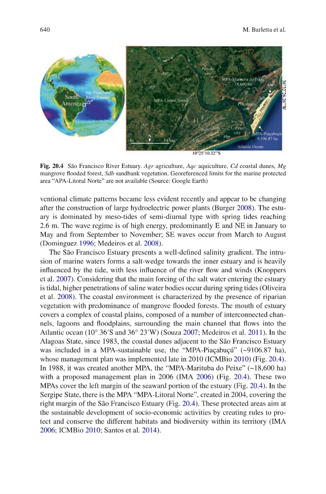
Atlantic ocean (10° 36′S and 36° 23′W) (Souza 2007; Medeiros et al. 2011). In the
Alagoas State, since 1983, the coastal dunes adjacent to the São Francisco Estuary
was included in a MPA-sustainable use, the “MPA-Piaçabuçú” (~9106.87 ha),
whose management plan was implemented late in 2010 (ICMBio 2010) (Fig. 20.4).
In 1988, it was created another MPA, the “MPA-Marituba do Peixe” (~18,600 ha)
with a proposed management plan in 2006 (IMA 2006) (Fig. 20.4). These two
MPAs cover the left margin of the seaward portion of the estuary (Fig. 20.4). In the
Sergipe State, there is the MPA “MPA-Litoral Norte”, created in 2004, covering the
right margin of the São Francisco Estuary (Fig. 20.4). These protected areas aim at
the sustainable development of socio-economic activities by creating rules to protect and conserve the different habitats and biodiversity within its territory (IMA
2006; ICMBio 2010; Santos et al. 2014).
Fig. 20.4 São Francisco River Estuary. Agr agriculture, Aqc aquiculture, Cd coastal dunes, Mg
mangrove flooded forest, Sdb sandbank vegetation. Georeferenced limits for the marine protected
area “APA-Litoral Norte” are not available (Source: Google Earth)
M. Barletta et al.