

586
L
g rey L
L
L
rad
DN
=
×
−
+
{[
/ max
] [
]}
max
m in
min
(19.1)
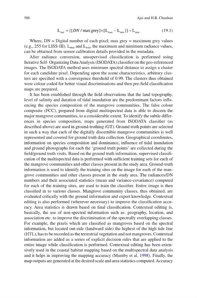
Where, DN = Digital number of each pixel; max grey = maximum grey values
(e.g., 255 for LISS-III). L max and L min , the maximum and minimum radiance values,
can be obtained from sensor calibration details provided in the metadata.
After radiance conversion, unsupervised classification is performed using
Iterative Self- Organizing Data Analysis (ISODATA) classifier on the geo- referenced
images. The ISODATA method uses minimum spectral distance to assign a cluster
for each candidate pixel. Depending upon the scene characteristics, arbitrary clusters are specified with a convergence threshold of 0.99. The clusters thus obtained
were colour coded for better visual discriminations and then pre-field classification
maps are prepared.
It has been established through the field observations that the land topography,
level of salinity and duration of tidal inundation are the predominant factors influencing the species composition of the mangrove communities. The false colour
composite (FCC), prepared from digital multispectral data is able to discern the
major mangrove communities, to a considerable extent. To identify the subtle differences in species composition, maps generated from ISODATA classifier (as
described above) are used in ground-truthing (GT). Ground truth points are selected
in such a way that each of the digitally discernible mangrove communities is well
represented and covered for ground truth data collection. Geographical coordinates,
information on species composition and dominance, influence of tidal inundation
and ground photographs for each the ‘ground truth points’ are collected during the
field/ground truth visits. Based on the ground truth information, supervised classification of the multispectral data is performed with sufficient training sets for each of
the mangrove communities and other classes present in the study area. Ground-truth
information is used to identify the training sites on the image for each of the mangrove communities and other classes present in the study area. The radiances/DN
numbers and their associated statistics (mean and variance-covariance) computed
for each of the training sites, are used to train the classifier. Entire image is then
classified in to various classes. Mangrove community classes, thus obtained, are
evaluated critically with the ground information and expert knowledge. Contextual
editing is also performed (wherever necessary) to improve the classification accuracy. Area statistics is drawn based on final classification. Contextual editing is,
basically, the use of non-spectral information such as: geography, location, and
association etc. to improve the discrimination of the spectrally overlapping classes.
For example, the pixels which are classified as mangroves based on the spectral
information, but located out-side (landward side) the highest of the high tide line
(HTL), has to be recorded as the terrestrial vegetation and not mangroves. Contextual
information are added as a series of explicit decision rules that are applied to the
entire image while classification is performed. Contextual editing has been extensively used in the coastal habitat mapping based on the multispectral data analysis
and it helps in improving the mapping accuracy (Mumby et al. 1998). Finally, the
map outputs are generated at the desired scale and area statistics computed. Accuracy
Ajai and H.B. Chauhan
L
g rey L
L
L
rad
DN
=
×
−
+
{[
/ max
] [
]}
max
m in
min
(19.1)
Where, DN = Digital number of each pixel; max grey = maximum grey values
(e.g., 255 for LISS-III). L max and L min , the maximum and minimum radiance values,
can be obtained from sensor calibration details provided in the metadata.
After radiance conversion, unsupervised classification is performed using
Iterative Self- Organizing Data Analysis (ISODATA) classifier on the geo- referenced
images. The ISODATA method uses minimum spectral distance to assign a cluster
for each candidate pixel. Depending upon the scene characteristics, arbitrary clusters are specified with a convergence threshold of 0.99. The clusters thus obtained
were colour coded for better visual discriminations and then pre-field classification
maps are prepared.
It has been established through the field observations that the land topography,
level of salinity and duration of tidal inundation are the predominant factors influencing the species composition of the mangrove communities. The false colour
composite (FCC), prepared from digital multispectral data is able to discern the
major mangrove communities, to a considerable extent. To identify the subtle differences in species composition, maps generated from ISODATA classifier (as
described above) are used in ground-truthing (GT). Ground truth points are selected
in such a way that each of the digitally discernible mangrove communities is well
represented and covered for ground truth data collection. Geographical coordinates,
information on species composition and dominance, influence of tidal inundation
and ground photographs for each the ‘ground truth points’ are collected during the
field/ground truth visits. Based on the ground truth information, supervised classification of the multispectral data is performed with sufficient training sets for each of
the mangrove communities and other classes present in the study area. Ground-truth
information is used to identify the training sites on the image for each of the mangrove communities and other classes present in the study area. The radiances/DN
numbers and their associated statistics (mean and variance-covariance) computed
for each of the training sites, are used to train the classifier. Entire image is then
classified in to various classes. Mangrove community classes, thus obtained, are
evaluated critically with the ground information and expert knowledge. Contextual
editing is also performed (wherever necessary) to improve the classification accuracy. Area statistics is drawn based on final classification. Contextual editing is,
basically, the use of non-spectral information such as: geography, location, and
association etc. to improve the discrimination of the spectrally overlapping classes.
For example, the pixels which are classified as mangroves based on the spectral
information, but located out-side (landward side) the highest of the high tide line
(HTL), has to be recorded as the terrestrial vegetation and not mangroves. Contextual
information are added as a series of explicit decision rules that are applied to the
entire image while classification is performed. Contextual editing has been extensively used in the coastal habitat mapping based on the multispectral data analysis
and it helps in improving the mapping accuracy (Mumby et al. 1998). Finally, the
map outputs are generated at the desired scale and area statistics computed. Accuracy
Ajai and H.B. Chauhan