

367
Mangroves were lost due to shorefront erosion and wash over sand deposits in the
peat swamps of inner parts in these islands.
Patibania island and Susnir Char are among the part of reserve forest that extends
from southwest of Fresarganj to northwest of Fresarganj across Patibania creek.
Mangroves are dwarfed in the inner parts of the forest due to the extensive growth
of hypersaline tracts resulted from drainage loss of tides in the region. Ridge forest
is extended all along the tidal creeks with extent of active tidal flat in the region.
Species richness of mangrove is positively related to the soil types and age of tidal
flat in the island. Richness is reduced in the inner part or older tidal flat of the island
that occupies high salt tolerant, salt marsh plants in the expanse of younger and
matured mangroves.
Mahisani or Mousuni Island is located along Muriganga river estuary on the west
of Patibania Island and separated by Pitt’s creek. Mangrove forests are largely
degraded in the island due to extent of human settlements, agricultural lands. Fish
farm plots and direct human uses of various land resources. Remaining forests are
extended towards northwest, south-southwest, and along a narrow strip parallel to
the active tidal bank of Pitt’s creek.
The above mentioned islands dominated by partial coverage of mangrove acts as
a bio – shield or natural buffers against the effects of cyclone and shoreline erosion.
Sediment stability is achieved in the younger deltaic alluviums by extensive growth
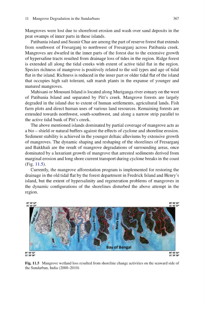
of mangroves. The dynamic shaping and reshaping of the shorelines of Fresarganj
and Bakkhali are the result of mangrove degradations of surrounding areas, once
dominated by a luxuriant growth of mangrove that arrested sediments derived from
marginal erosion and long shore current transport during cyclone breaks in the coast
(Fig. 11.5).
Currently, the mangrove afforestation program is implemented for restoring the
drainage in the old tidal flat by the forest department in Fredrick Island and Henry’s
island, but the extent of hypersalinity and regeneration problems of mangroves in
the dynamic configurations of the shorelines disturbed the above attempt in the
region.
Fig. 11.5 Mangrove wetland loss resulted from shoreline change activities on the seaward side of
the Sundarban, India (2000–2010)
11 Mangrove Degradation in the Sundarbans
Mangroves were lost due to shorefront erosion and wash over sand deposits in the
peat swamps of inner parts in these islands.
Patibania island and Susnir Char are among the part of reserve forest that extends
from southwest of Fresarganj to northwest of Fresarganj across Patibania creek.
Mangroves are dwarfed in the inner parts of the forest due to the extensive growth
of hypersaline tracts resulted from drainage loss of tides in the region. Ridge forest
is extended all along the tidal creeks with extent of active tidal flat in the region.
Species richness of mangrove is positively related to the soil types and age of tidal
flat in the island. Richness is reduced in the inner part or older tidal flat of the island
that occupies high salt tolerant, salt marsh plants in the expanse of younger and
matured mangroves.
Mahisani or Mousuni Island is located along Muriganga river estuary on the west
of Patibania Island and separated by Pitt’s creek. Mangrove forests are largely
degraded in the island due to extent of human settlements, agricultural lands. Fish
farm plots and direct human uses of various land resources. Remaining forests are
extended towards northwest, south-southwest, and along a narrow strip parallel to
the active tidal bank of Pitt’s creek.
The above mentioned islands dominated by partial coverage of mangrove acts as
a bio – shield or natural buffers against the effects of cyclone and shoreline erosion.
Sediment stability is achieved in the younger deltaic alluviums by extensive growth
of mangroves. The dynamic shaping and reshaping of the shorelines of Fresarganj
and Bakkhali are the result of mangrove degradations of surrounding areas, once
dominated by a luxuriant growth of mangrove that arrested sediments derived from
marginal erosion and long shore current transport during cyclone breaks in the coast
(Fig. 11.5).
Currently, the mangrove afforestation program is implemented for restoring the
drainage in the old tidal flat by the forest department in Fredrick Island and Henry’s
island, but the extent of hypersalinity and regeneration problems of mangroves in
the dynamic configurations of the shorelines disturbed the above attempt in the
region.
Fig. 11.5 Mangrove wetland loss resulted from shoreline change activities on the seaward side of
the Sundarban, India (2000–2010)
11 Mangrove Degradation in the Sundarbans