

350
10.5 Impacts on Marine Ecology
10.5.1 Wallis Lake
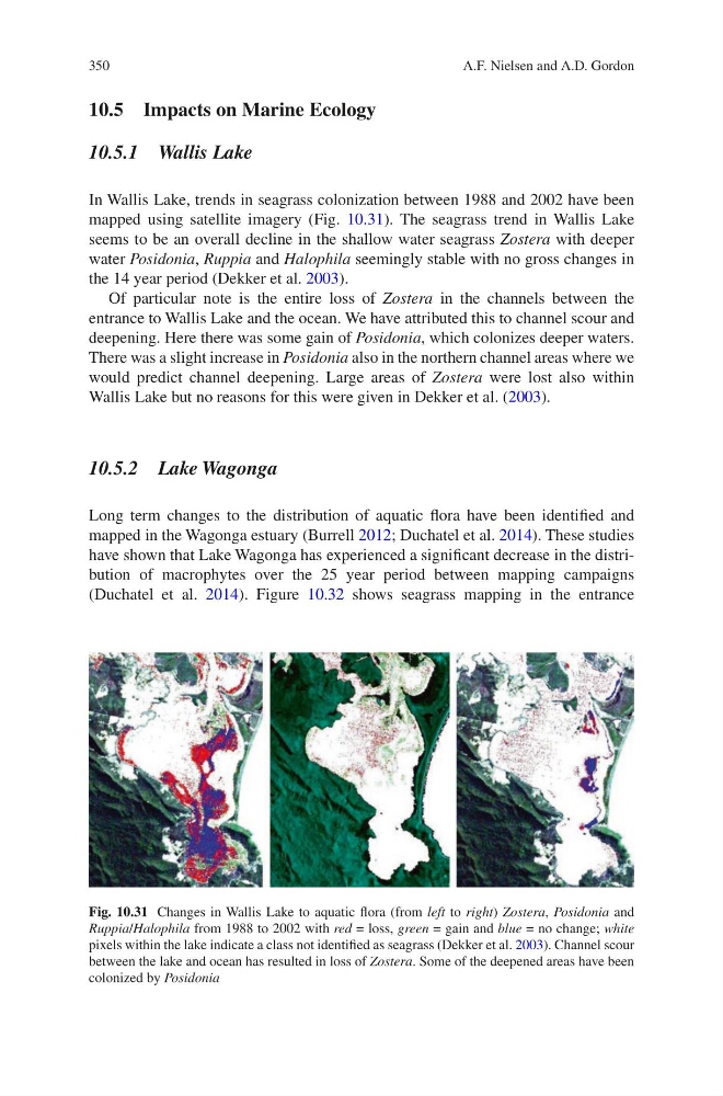
In Wallis Lake, trends in seagrass colonization between 1988 and 2002 have been
mapped using satellite imagery (Fig. 10.31). The seagrass trend in Wallis Lake
seems to be an overall decline in the shallow water seagrass Zostera with deeper
water Posidonia, Ruppia and Halophila seemingly stable with no gross changes in
the 14 year period (Dekker et al. 2003).
Of particular note is the entire loss of Zostera in the channels between the
entrance to Wallis Lake and the ocean. We have attributed this to channel scour and
deepening. Here there was some gain of Posidonia, which colonizes deeper waters.
There was a slight increase in Posidonia also in the northern channel areas where we
would predict channel deepening. Large areas of Zostera were lost also within
Wallis Lake but no reasons for this were given in Dekker et al. (2003).
10.5.2 Lake Wagonga
Long term changes to the distribution of aquatic flora have been identified and
mapped in the Wagonga estuary (Burrell 2012; Duchatel et al. 2014). These studies
have shown that Lake Wagonga has experienced a significant decrease in the distribution of macrophytes over the 25 year period between mapping campaigns
(Duchatel et al. 2014). Figure 10.32 shows seagrass mapping in the entrance
Fig. 10.31 Changes in Wallis Lake to aquatic flora (from left to right) Zostera, Posidonia and
Ruppia/Halophila from 1988 to 2002 with red = loss, green = gain and blue = no change; white
pixels within the lake indicate a class not identified as seagrass (Dekker et al. 2003). Channel scour
between the lake and ocean has resulted in loss of Zostera. Some of the deepened areas have been
colonized by Posidonia
A.F. Nielsen and A.D. Gordon
10.5 Impacts on Marine Ecology
10.5.1 Wallis Lake
In Wallis Lake, trends in seagrass colonization between 1988 and 2002 have been
mapped using satellite imagery (Fig. 10.31). The seagrass trend in Wallis Lake
seems to be an overall decline in the shallow water seagrass Zostera with deeper
water Posidonia, Ruppia and Halophila seemingly stable with no gross changes in
the 14 year period (Dekker et al. 2003).
Of particular note is the entire loss of Zostera in the channels between the
entrance to Wallis Lake and the ocean. We have attributed this to channel scour and
deepening. Here there was some gain of Posidonia, which colonizes deeper waters.
There was a slight increase in Posidonia also in the northern channel areas where we
would predict channel deepening. Large areas of Zostera were lost also within
Wallis Lake but no reasons for this were given in Dekker et al. (2003).
10.5.2 Lake Wagonga
Long term changes to the distribution of aquatic flora have been identified and
mapped in the Wagonga estuary (Burrell 2012; Duchatel et al. 2014). These studies
have shown that Lake Wagonga has experienced a significant decrease in the distribution of macrophytes over the 25 year period between mapping campaigns
(Duchatel et al. 2014). Figure 10.32 shows seagrass mapping in the entrance
Fig. 10.31 Changes in Wallis Lake to aquatic flora (from left to right) Zostera, Posidonia and
Ruppia/Halophila from 1988 to 2002 with red = loss, green = gain and blue = no change; white
pixels within the lake indicate a class not identified as seagrass (Dekker et al. 2003). Channel scour
between the lake and ocean has resulted in loss of Zostera. Some of the deepened areas have been
colonized by Posidonia
A.F. Nielsen and A.D. Gordon