

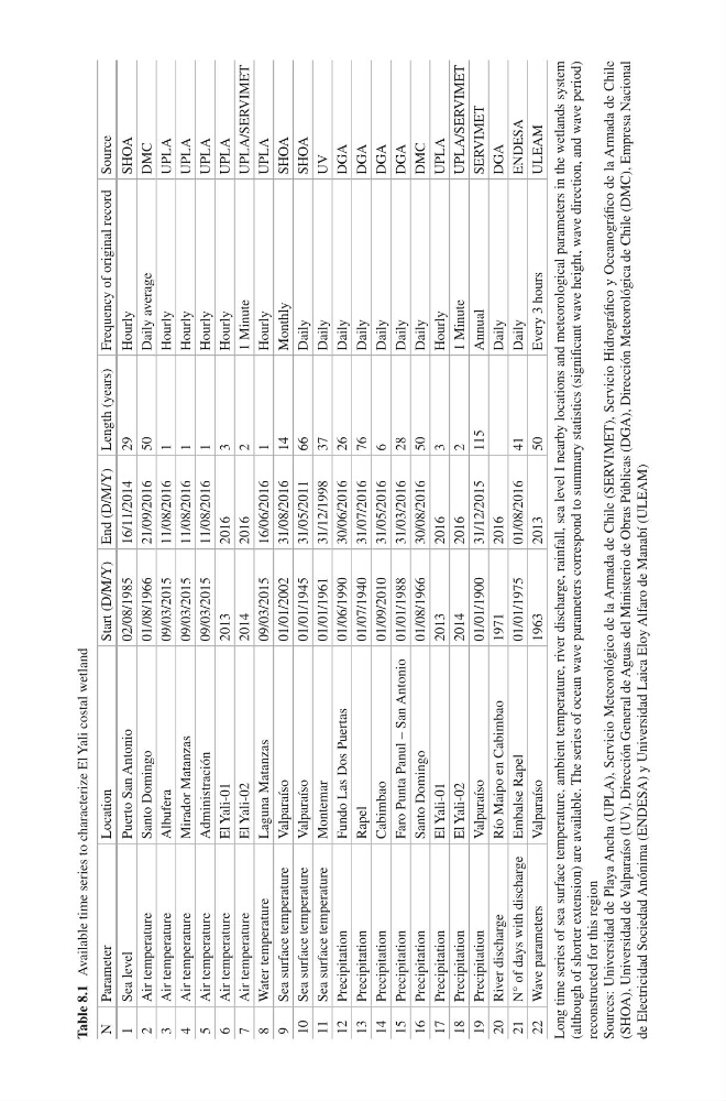
Table 8.1 Available time series to characterize El Yali costal wetland
N
Parameter
Location
Start (D/M/Y) End (D/M/Y) Length (years) Frequency of original record Source
1
Sea level
Puerto San Antonio
02/08/1985
16/11/2014
29
Hourly
SHOA
2
Air temperature
Santo Domingo
01/08/1966
21/09/2016
50
Daily average
DMC
3
Air temperature
Albufera
09/03/2015
11/08/2016
1
Hourly
UPLA
4
Air temperature
Mirador Matanzas
09/03/2015
11/08/2016
1
Hourly
UPLA
5
Air temperature
Administración
09/03/2015
11/08/2016
1
Hourly
UPLA
6
Air temperature
El Yali-01
2013
2016
3
Hourly
UPLA
7
Air temperature
El Yali-02
2014
2016
2
1 Minute
UPLA/SERVIMET
8
Water temperature
Laguna Matanzas
09/03/2015
16/06/2016
1
Hourly
UPLA
9
Sea surface temperature
Valparaíso
01/01/2002
31/08/2016
14
Monthly
SHOA
10 Sea surface temperature
Valparaíso
01/01/1945
31/05/2011
66
Daily
SHOA
11 Sea surface temperature
Montemar
01/01/1961
31/12/1998
37
Daily
UV
12 Precipitation
Fundo Las Dos Puertas
01/06/1990
30/06/2016
26
Daily
DGA
13 Precipitation
Rapel
01/07/1940
31/07/2016
76
Daily
DGA
14 Precipitation
Cabimbao
01/09/2010
31/05/2016
6
Daily
DGA
15 Precipitation
Faro Punta Panul – San Antonio 01/01/1988
31/03/2016
28
Daily
DGA
16 Precipitation
Santo Domingo
01/08/1966
30/08/2016
50
Daily
DMC
17 Precipitation
El Yali-01
2013
2016
3
Hourly
UPLA
18 Precipitation
El Yali-02
2014
2016
2
1 Minute
UPLA/SERVIMET
19 Precipitation
Valparaíso
01/01/1900
31/12/2015
115
Annual
SERVIMET
20 River discharge
Río Maipo en Cabimbao
1971
2016
Daily
DGA
21 N° of days with discharge Embalse Rapel
01/01/1975
01/08/2016
41
Daily
ENDESA
22 Wave parameters
Valparaíso
1963
2013
50
Every 3 hours
ULEAM
Long time series of sea surface temperature, ambient temperature, river discharge, rainfall, sea level I nearby locations and meteorological parameters in the wetlands system
(although of shorter extension) are available. The series of ocean wave parameters correspond to summary statistics (significant wave height, wave direction, and wave period)
reconstructed for this region
Sources: Universidad de Playa Ancha (UPLA), Servicio Meteorológico de la Armada de Chile (SERVIMET), Servicio Hidrográfico y Oceanográfico de la Armada de Chile
(SHOA), Universidad de Valparaíso (UV), Dirección General de Aguas del Ministerio de Obras Públicas (DGA), Dirección Meteorológica de Chile (DMC), Empresa Nacional
de Electricidad Sociedad Anónima (ENDESA) y Universidad Laica Eloy Alfaro de Manabí (ULEAM)
N
Parameter
Location
Start (D/M/Y) End (D/M/Y) Length (years) Frequency of original record Source
1
Sea level
Puerto San Antonio
02/08/1985
16/11/2014
29
Hourly
SHOA
2
Air temperature
Santo Domingo
01/08/1966
21/09/2016
50
Daily average
DMC
3
Air temperature
Albufera
09/03/2015
11/08/2016
1
Hourly
UPLA
4
Air temperature
Mirador Matanzas
09/03/2015
11/08/2016
1
Hourly
UPLA
5
Air temperature
Administración
09/03/2015
11/08/2016
1
Hourly
UPLA
6
Air temperature
El Yali-01
2013
2016
3
Hourly
UPLA
7
Air temperature
El Yali-02
2014
2016
2
1 Minute
UPLA/SERVIMET
8
Water temperature
Laguna Matanzas
09/03/2015
16/06/2016
1
Hourly
UPLA
9
Sea surface temperature
Valparaíso
01/01/2002
31/08/2016
14
Monthly
SHOA
10 Sea surface temperature
Valparaíso
01/01/1945
31/05/2011
66
Daily
SHOA
11 Sea surface temperature
Montemar
01/01/1961
31/12/1998
37
Daily
UV
12 Precipitation
Fundo Las Dos Puertas
01/06/1990
30/06/2016
26
Daily
DGA
13 Precipitation
Rapel
01/07/1940
31/07/2016
76
Daily
DGA
14 Precipitation
Cabimbao
01/09/2010
31/05/2016
6
Daily
DGA
15 Precipitation
Faro Punta Panul – San Antonio 01/01/1988
31/03/2016
28
Daily
DGA
16 Precipitation
Santo Domingo
01/08/1966
30/08/2016
50
Daily
DMC
17 Precipitation
El Yali-01
2013
2016
3
Hourly
UPLA
18 Precipitation
El Yali-02
2014
2016
2
1 Minute
UPLA/SERVIMET
19 Precipitation
Valparaíso
01/01/1900
31/12/2015
115
Annual
SERVIMET
20 River discharge
Río Maipo en Cabimbao
1971
2016
Daily
DGA
21 N° of days with discharge Embalse Rapel
01/01/1975
01/08/2016
41
Daily
ENDESA
22 Wave parameters
Valparaíso
1963
2013
50
Every 3 hours
ULEAM
Long time series of sea surface temperature, ambient temperature, river discharge, rainfall, sea level I nearby locations and meteorological parameters in the wetlands system
(although of shorter extension) are available. The series of ocean wave parameters correspond to summary statistics (significant wave height, wave direction, and wave period)
reconstructed for this region
Sources: Universidad de Playa Ancha (UPLA), Servicio Meteorológico de la Armada de Chile (SERVIMET), Servicio Hidrográfico y Oceanográfico de la Armada de Chile
(SHOA), Universidad de Valparaíso (UV), Dirección General de Aguas del Ministerio de Obras Públicas (DGA), Dirección Meteorológica de Chile (DMC), Empresa Nacional
de Electricidad Sociedad Anónima (ENDESA) y Universidad Laica Eloy Alfaro de Manabí (ULEAM)