

251
hourly sea level record for almost 30 years, air temperature for 50 years, precipitations
for 76 years, and three series of coastal water surface temperature allow to construct a
series of 71 years, 45 years of water discharge nearby Maipo river mouth (delimiting
the wetland to the north) and a 41 years record of Rapel dam (delimiting the wetland
to the south) discharges. During the last years it has been possible to monitor the wetland by combining different instruments, measuring atmospheric variables with two
weather stations and four temperature loggers. One of the weather stations was located
in lagoon Matanzas. The available data is summarized in Table 8.1.
To estimate linear trends, all series were transformed to monthly series and a
linear fit was applied by the minimum square method, determining the uncertainty
at 95% confidence.
From 2010 on, some parameter of the water bodies have been measured in situ
(temperature, pH, conductivity, dissolved oxygen). Additionally, with monthly frequency, the surface of coastal lagoons and lagoon Matanzas was measured by walking along their perimeter with a GPS whose positioning error is less than 3 m. This
was complemented with satellite imagery and maps from the Military Geographical
Institute, that allow having an almost inter-decadal sequence to observe the morphological changes experienced by the coastal lagoon and El Yali brook mouth.
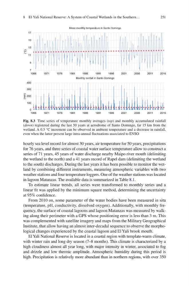
El Yali National Reserve is located in a coastal region with template-warm climate,
with winter rain and long dry season (7–8 months). This climate is characterized by a
high cloudiness almost all year long, with major intensity in winter, associated to fog
and drizzle and low thermic amplitude. Atmospheric humidity during this period is
high. Precipitation is relatively more abundant than in northern regions, with over 350
17
15
13
11
9
7
1966
1971
1976
1981
(°C)
(mm)
1986
Monthly rainfall in Santo Domingo
Mean monthly temperature in Santo Domingo
1991
1996
2001
2006
2011
2016
1966
1971
1976
1981
1986
1991
1996
2001
2006
2011
2016
400
300
200
100
0
Fig. 8.3 Time series of temperature monthly averages (top) and monthly accumulated rainfall
(down) registered during the last 50 years at aerodrome of Santo Domingo, far 15 km from the
wetland. A 0.5 °C increment can be observed in ambient temperature and a decrease in rainfall,
even when the latter present large intra-annual fluctuations associated to ENSO
8 El Yali National Reserve: A System of Coastal Wetlands in the Southern…
hourly sea level record for almost 30 years, air temperature for 50 years, precipitations
for 76 years, and three series of coastal water surface temperature allow to construct a
series of 71 years, 45 years of water discharge nearby Maipo river mouth (delimiting
the wetland to the north) and a 41 years record of Rapel dam (delimiting the wetland
to the south) discharges. During the last years it has been possible to monitor the wetland by combining different instruments, measuring atmospheric variables with two
weather stations and four temperature loggers. One of the weather stations was located
in lagoon Matanzas. The available data is summarized in Table 8.1.
To estimate linear trends, all series were transformed to monthly series and a
linear fit was applied by the minimum square method, determining the uncertainty
at 95% confidence.
From 2010 on, some parameter of the water bodies have been measured in situ
(temperature, pH, conductivity, dissolved oxygen). Additionally, with monthly frequency, the surface of coastal lagoons and lagoon Matanzas was measured by walking along their perimeter with a GPS whose positioning error is less than 3 m. This
was complemented with satellite imagery and maps from the Military Geographical
Institute, that allow having an almost inter-decadal sequence to observe the morphological changes experienced by the coastal lagoon and El Yali brook mouth.
El Yali National Reserve is located in a coastal region with template-warm climate,
with winter rain and long dry season (7–8 months). This climate is characterized by a
high cloudiness almost all year long, with major intensity in winter, associated to fog
and drizzle and low thermic amplitude. Atmospheric humidity during this period is
high. Precipitation is relatively more abundant than in northern regions, with over 350
17
15
13
11
9
7
1966
1971
1976
1981
(°C)
(mm)
1986
Monthly rainfall in Santo Domingo
Mean monthly temperature in Santo Domingo
1991
1996
2001
2006
2011
2016
1966
1971
1976
1981
1986
1991
1996
2001
2006
2011
2016
400
300
200
100
0
Fig. 8.3 Time series of temperature monthly averages (top) and monthly accumulated rainfall
(down) registered during the last 50 years at aerodrome of Santo Domingo, far 15 km from the
wetland. A 0.5 °C increment can be observed in ambient temperature and a decrease in rainfall,
even when the latter present large intra-annual fluctuations associated to ENSO
8 El Yali National Reserve: A System of Coastal Wetlands in the Southern…