

247
(b) To describe the changes that the El Yali wetland is experiencing as response to
Climate Change and the influence of multiple anthropogenic pressures. El Yali
coastal wetland is located in the southern limit of the semi -arid wetland (Figueroa
et al. 2009; Vidal-Abarca et al. 2011), but on its RAMSAR file it has been
described as a Mediterranean wetland (RAMSAR 1996). This confusion is
because of its location in the limit where the semi-arid climate is extending southwards, over the Mediterranean Central Chile. This situation offers an opportunity
to study the effects of these changes on waterbodies and associated biotopes.
8.2 Geological Context and Natural History of the Site
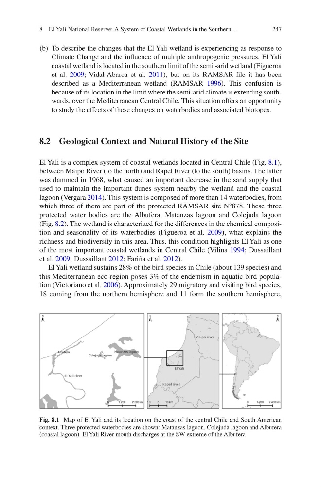
El Yali is a complex system of coastal wetlands located in Central Chile (Fig. 8.1),
between Maipo River (to the north) and Rapel River (to the south) basins. The latter
was dammed in 1968, what caused an important decrease in the sand supply that
used to maintain the important dunes system nearby the wetland and the coastal
lagoon (Vergara 2014). This system is composed of more than 14 waterbodies, from
which three of them are part of the protected RAMSAR site N°878. These three
protected water bodies are the Albufera, Matanzas lagoon and Colejuda lagoon
(Fig. 8.2). The wetland is characterized for the differences in the chemical composition and seasonality of its waterbodies (Figueroa et al. 2009), what explains the
richness and biodiversity in this area. Thus, this condition highlights El Yali as one
of the most important coastal wetlands in Central Chile (Vilina 1994; Dussaillant
et al. 2009; Dussaillant 2012; Fariña et al. 2012).
El Yali wetland sustains 28% of the bird species in Chile (about 139 species) and
this Mediterranean eco-region poses 3% of the endemism in aquatic bird population (Victoriano et al. 2006). Approximately 29 migratory and visiting bird species,
18 coming from the northern hemisphere and 11 form the southern hemisphere,
Fig. 8.1 Map of El Yali and its location on the coast of the central Chile and South American
context. Three protected waterbodies are shown: Matanzas lagoon, Colejuda lagoon and Albufera
(coastal lagoon). El Yali River mouth discharges at the SW extreme of the Albufera
8 El Yali National Reserve: A System of Coastal Wetlands in the Southern…
(b) To describe the changes that the El Yali wetland is experiencing as response to
Climate Change and the influence of multiple anthropogenic pressures. El Yali
coastal wetland is located in the southern limit of the semi -arid wetland (Figueroa
et al. 2009; Vidal-Abarca et al. 2011), but on its RAMSAR file it has been
described as a Mediterranean wetland (RAMSAR 1996). This confusion is
because of its location in the limit where the semi-arid climate is extending southwards, over the Mediterranean Central Chile. This situation offers an opportunity
to study the effects of these changes on waterbodies and associated biotopes.
8.2 Geological Context and Natural History of the Site
El Yali is a complex system of coastal wetlands located in Central Chile (Fig. 8.1),
between Maipo River (to the north) and Rapel River (to the south) basins. The latter
was dammed in 1968, what caused an important decrease in the sand supply that
used to maintain the important dunes system nearby the wetland and the coastal
lagoon (Vergara 2014). This system is composed of more than 14 waterbodies, from
which three of them are part of the protected RAMSAR site N°878. These three
protected water bodies are the Albufera, Matanzas lagoon and Colejuda lagoon
(Fig. 8.2). The wetland is characterized for the differences in the chemical composition and seasonality of its waterbodies (Figueroa et al. 2009), what explains the
richness and biodiversity in this area. Thus, this condition highlights El Yali as one
of the most important coastal wetlands in Central Chile (Vilina 1994; Dussaillant
et al. 2009; Dussaillant 2012; Fariña et al. 2012).
El Yali wetland sustains 28% of the bird species in Chile (about 139 species) and
this Mediterranean eco-region poses 3% of the endemism in aquatic bird population (Victoriano et al. 2006). Approximately 29 migratory and visiting bird species,
18 coming from the northern hemisphere and 11 form the southern hemisphere,
Fig. 8.1 Map of El Yali and its location on the coast of the central Chile and South American
context. Three protected waterbodies are shown: Matanzas lagoon, Colejuda lagoon and Albufera
(coastal lagoon). El Yali River mouth discharges at the SW extreme of the Albufera
8 El Yali National Reserve: A System of Coastal Wetlands in the Southern…