

88
3.2.4 Hydrology
The hydrology of Cameroon is influenced among other factors by the general
scheme of the Biafra Bay, climate, topography and geomorphology (Olivry 1986).
Hydrological conditions of the Biafra bay are relatively stable. The mass of surface
water remains warm (25–28 °C) all the year with relatively low salinities (below
35‰). In estuaries, the salinity is still less than 20‰ and dilution is very fast. Less
than 30 km from the ocean, salinity is null or almost during the most part of the year.
The estuary waters present a stratification with continental waters dominance,
warm and rich in nutrients and sediment loads that float on marine water, saltier,
colder and clearer (Baltzer et al. 1995). Coastal rivers constitute two subsets around
the Sanaga river, the country main river which drains itself a watershed of about
135,000 km
2
, with 920 km in length. During the long rainy season, seawater that
waters daily twice these ecosystems is still below 10‰, while in the dry season, it
varies between 4 and 20‰. Mangroves of the Cameroon Estuary are constantly
watered by brackish water resulting from the dilution of seawater by fresh water
from rivers and heavy rainfall.
Tides influence the structure, composition and distribution of mangrove vegetation.
Similarly, they affect the salinity of the soil and the evaporation rate. Tide regime
is semi-diurnal in Cameroon with a maximum amplitude that is approximately 3 m
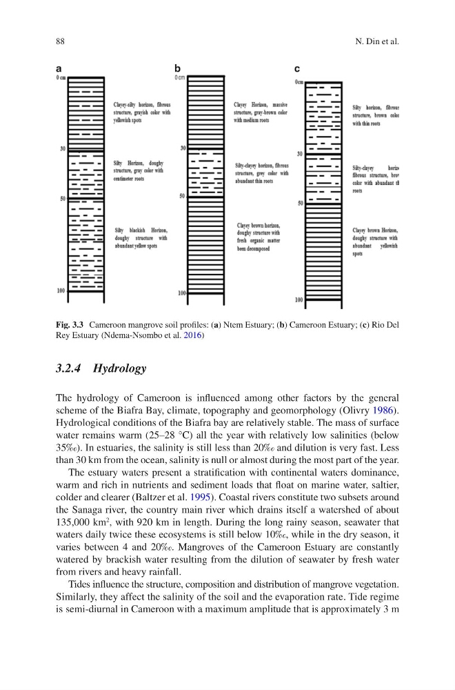
Fig. 3.3 Cameroon mangrove soil profiles: (a) Ntem Estuary; (b) Cameroon Estuary; (c) Rio Del
Rey Estuary (Ndema-Nsombo et al. 2016)
N. Din et al.
3.2.4 Hydrology
The hydrology of Cameroon is influenced among other factors by the general
scheme of the Biafra Bay, climate, topography and geomorphology (Olivry 1986).
Hydrological conditions of the Biafra bay are relatively stable. The mass of surface
water remains warm (25–28 °C) all the year with relatively low salinities (below
35‰). In estuaries, the salinity is still less than 20‰ and dilution is very fast. Less
than 30 km from the ocean, salinity is null or almost during the most part of the year.
The estuary waters present a stratification with continental waters dominance,
warm and rich in nutrients and sediment loads that float on marine water, saltier,
colder and clearer (Baltzer et al. 1995). Coastal rivers constitute two subsets around
the Sanaga river, the country main river which drains itself a watershed of about
135,000 km
2
, with 920 km in length. During the long rainy season, seawater that
waters daily twice these ecosystems is still below 10‰, while in the dry season, it
varies between 4 and 20‰. Mangroves of the Cameroon Estuary are constantly
watered by brackish water resulting from the dilution of seawater by fresh water
from rivers and heavy rainfall.
Tides influence the structure, composition and distribution of mangrove vegetation.
Similarly, they affect the salinity of the soil and the evaporation rate. Tide regime
is semi-diurnal in Cameroon with a maximum amplitude that is approximately 3 m
Fig. 3.3 Cameroon mangrove soil profiles: (a) Ntem Estuary; (b) Cameroon Estuary; (c) Rio Del
Rey Estuary (Ndema-Nsombo et al. 2016)
N. Din et al.