

27.2 Tangible Elements
405
TABLE 27.2. Classification of selected surface transportation features used by the U.S. Geological Survey for
digitailine graphs.
Feature
type
Classes
Point
Bridge abutment
Tunnel portal
Gate
Cul-de-sac
Dead end
Subclasses
Other attributes
Line
Drawbridge
Class I road
(primary)
Undivided, divided by centerline,
divided with lanes separated, one-way
Number of lanes
Interstate route number
U.S. route number
State route number
Class 2 road
(secondary)
Undivided, divided by centerline,
divided with lanes separated, one-way
Reservation, park, or military route number
County route number
Road width
Class 3 road
Class 4 road
Class 5 trail
Undivided, divided by centerline,
divided with lanes separated, one-way
Undivided, one-way
Four-wheel drive, other than four-wheeldrive vehicle
Footbridge
Road ferry crossing
Railroad
Railroad in street
Carline
Cog railroad
Source: USGS, 1990.
In tunnel, on bridge,
Elevated, rapid transit,
Private, U.S. government
tem is perceived and used by people. For example,
the addition of a cell phone tower will have a minimal direct impact on an ecosystem, but it will improve the accessibility of people in this ecosystem
to information, thereby increasing the range of human activities that can be conducted in this ecosystem.
27.2.1 Transportation Corridors
and Junctions
Transportation systems are composed of corridors,
which provide topological connection, and junctions or stations on the network. In terms of spatial data representation, the corridors are commonly
represented as linear objects and the junctions as
point objects or nodes on the network. The linear
objects can represent roads of various types, railroads, navigable rivers and canals, transit networks,
runways, and hiking or biking trails. The point objects are destinations, junctions, or facilities and
can include airports, highway or rail transfer terminals, and water ports.
The direct effects of the transportation systems
can often be discerned with simple locational information. For example, a forest that is bisected by
Number of tracks
Angle of clockwise rotation
a road will tend to provide lower-quality habitat for
large mammals than the same forest without the
road (i.e., few deer-car accidents occur in the forest). Also, roads can act as firebreaks and increase
light penetration into a forest canopy. Attributes
about the transportation network can improve our
understanding of the direct and, especially, indirect
effects of the transportation network. Attributes describing links and junctions in a transportation network include jurisdiction, capacity, actual volume
(which is highly variable in time), pavement quality, and width. Indirect effects involve the relations
between the quality of transportation links and the
tendency for land around these links to be used for
specific purposes (e.g., residential and commercial
development). All other things being equal, a site
with good transportation connections will tend to
be more susceptible to development or "improvement" than a site without such connections.
Spatial and attribute data on transportation networks are usually available in some form because
they provide an essential base layer for many management activities. In the United States, the U.S.
Geological Survey (USGS) distributes digital line
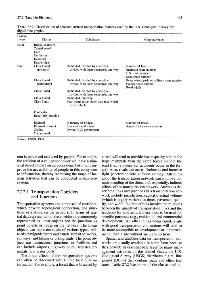
graphs (DLGs) that contain roads and other features. Table 27.2 lists some of the classes and at-
405
TABLE 27.2. Classification of selected surface transportation features used by the U.S. Geological Survey for
digitailine graphs.
Feature
type
Classes
Point
Bridge abutment
Tunnel portal
Gate
Cul-de-sac
Dead end
Subclasses
Other attributes
Line
Drawbridge
Class I road
(primary)
Undivided, divided by centerline,
divided with lanes separated, one-way
Number of lanes
Interstate route number
U.S. route number
State route number
Class 2 road
(secondary)
Undivided, divided by centerline,
divided with lanes separated, one-way
Reservation, park, or military route number
County route number
Road width
Class 3 road
Class 4 road
Class 5 trail
Undivided, divided by centerline,
divided with lanes separated, one-way
Undivided, one-way
Four-wheel drive, other than four-wheeldrive vehicle
Footbridge
Road ferry crossing
Railroad
Railroad in street
Carline
Cog railroad
Source: USGS, 1990.
In tunnel, on bridge,
Elevated, rapid transit,
Private, U.S. government
tem is perceived and used by people. For example,
the addition of a cell phone tower will have a minimal direct impact on an ecosystem, but it will improve the accessibility of people in this ecosystem
to information, thereby increasing the range of human activities that can be conducted in this ecosystem.
27.2.1 Transportation Corridors
and Junctions
Transportation systems are composed of corridors,
which provide topological connection, and junctions or stations on the network. In terms of spatial data representation, the corridors are commonly
represented as linear objects and the junctions as
point objects or nodes on the network. The linear
objects can represent roads of various types, railroads, navigable rivers and canals, transit networks,
runways, and hiking or biking trails. The point objects are destinations, junctions, or facilities and
can include airports, highway or rail transfer terminals, and water ports.
The direct effects of the transportation systems
can often be discerned with simple locational information. For example, a forest that is bisected by
Number of tracks
Angle of clockwise rotation
a road will tend to provide lower-quality habitat for
large mammals than the same forest without the
road (i.e., few deer-car accidents occur in the forest). Also, roads can act as firebreaks and increase
light penetration into a forest canopy. Attributes
about the transportation network can improve our
understanding of the direct and, especially, indirect
effects of the transportation network. Attributes describing links and junctions in a transportation network include jurisdiction, capacity, actual volume
(which is highly variable in time), pavement quality, and width. Indirect effects involve the relations
between the quality of transportation links and the
tendency for land around these links to be used for
specific purposes (e.g., residential and commercial
development). All other things being equal, a site
with good transportation connections will tend to
be more susceptible to development or "improvement" than a site without such connections.
Spatial and attribute data on transportation networks are usually available in some form because
they provide an essential base layer for many management activities. In the United States, the U.S.
Geological Survey (USGS) distributes digital line
graphs (DLGs) that contain roads and other features. Table 27.2 lists some of the classes and at-