

374
Geomorphic Patterns, Processes, and Perspectives in Aquatic Assessment
Climate
................................................................................................................ " ... ~
Watershed Hydrology
r .... ·················································
(a)
Watershed
Composition
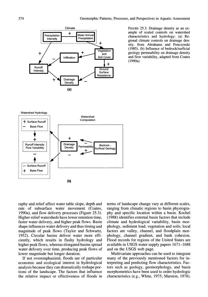
FIGURE 25.3. Drainage density as an example of scaled controls on watershed
characteristics and hydrology: (a) Regional climate controls on drainage density, from Abrahams and Ponczynski
(1985). (b) Influence of bedrock/surficial
geology permeability on drainage density
and flow variability, adapted from Coates
(1990a).
! + Surface Runoff
1
...........................................................................................
Base Flow
!
1
N
: i
~--+--,:crS-U-:-IC~-~-r~-~-O--IO-gy.,
, , . . . . . . . . . . . . . . . . . . . . . . . . . . . . . . . . . . . . . . . . . . . . . . . . . . . . . . . , I 1 _ _ _
, ...................... ,
+
r··R~~~ff·i~;~~·~·i~···i
: Flow Variability :
L ............................... ~
(b)
raphy and relief affect water table slope, depth and
rate of subsurface water movement (Coates,
1990a), and flow delivery processes (Figure 25.3).
Higher-relief watersheds have lower retention time,
faster water delivery, and higher peak flows. Basin
shape influences water delivery and thus timing and
magnitude of peak flows (Taylor and Schwartz,
1952). Circular basins deliver water more efficiently, which results in flashy hydrology and
higher peak flows, whereas elongated basins spread
water delivery over time, producing peak flows of
lower magnitude but longer duration.
If not overemphasized, floods are of particular
economic and ecological interest in hydrological
analysis because they can dramatically reshape portions of the landscape. The factors that influence
the relative impact or effectiveness of floods in
terms of landscape change vary at different scales,
ranging from climatic regions to basin physiography and specific location within a basin. Kochel
(1988) identifies external basin factors that include
climate and hydrological variability, basin morphology, sediment load, vegetation and soils; local
factors are valley, channel, and floodplain morphology, channel gradient, and bank cohesion.
Flood records for regions of the United States are
available in USGS water supply papers 1671-1688
and on the USGS web page.
Multivariate approaches can be used to integrate
many of the previously mentioned factors for interpreting and predicting flow characteristics. Factors such as geology, geomorphology, and basin
morphometrics have been used to order hydrologic
characteristics (e.g., White, 1975; Marston, 1978).
Geomorphic Patterns, Processes, and Perspectives in Aquatic Assessment
Climate
................................................................................................................ " ... ~
Watershed Hydrology
r .... ·················································
(a)
Watershed
Composition
FIGURE 25.3. Drainage density as an example of scaled controls on watershed
characteristics and hydrology: (a) Regional climate controls on drainage density, from Abrahams and Ponczynski
(1985). (b) Influence of bedrock/surficial
geology permeability on drainage density
and flow variability, adapted from Coates
(1990a).
! + Surface Runoff
1
...........................................................................................
Base Flow
!
1
N
: i
~--+--,:crS-U-:-IC~-~-r~-~-O--IO-gy.,
, , . . . . . . . . . . . . . . . . . . . . . . . . . . . . . . . . . . . . . . . . . . . . . . . . . . . . . . . , I 1 _ _ _
, ...................... ,
+
r··R~~~ff·i~;~~·~·i~···i
: Flow Variability :
L ............................... ~
(b)
raphy and relief affect water table slope, depth and
rate of subsurface water movement (Coates,
1990a), and flow delivery processes (Figure 25.3).
Higher-relief watersheds have lower retention time,
faster water delivery, and higher peak flows. Basin
shape influences water delivery and thus timing and
magnitude of peak flows (Taylor and Schwartz,
1952). Circular basins deliver water more efficiently, which results in flashy hydrology and
higher peak flows, whereas elongated basins spread
water delivery over time, producing peak flows of
lower magnitude but longer duration.
If not overemphasized, floods are of particular
economic and ecological interest in hydrological
analysis because they can dramatically reshape portions of the landscape. The factors that influence
the relative impact or effectiveness of floods in
terms of landscape change vary at different scales,
ranging from climatic regions to basin physiography and specific location within a basin. Kochel
(1988) identifies external basin factors that include
climate and hydrological variability, basin morphology, sediment load, vegetation and soils; local
factors are valley, channel, and floodplain morphology, channel gradient, and bank cohesion.
Flood records for regions of the United States are
available in USGS water supply papers 1671-1688
and on the USGS web page.
Multivariate approaches can be used to integrate
many of the previously mentioned factors for interpreting and predicting flow characteristics. Factors such as geology, geomorphology, and basin
morphometrics have been used to order hydrologic
characteristics (e.g., White, 1975; Marston, 1978).