

25.4 Hydrological Processes
373
Hydrograph dominated by
Thin soils, high to low permeability
Footslopes concave
direct precipitation and return
flow. Subsurface storm flow less
important.
Valley bottoms wide
t
Hydrograph dominated by
Hortonian overland flow.
Subsurface storm flow
importance reduced.
Variable
Source
Concept
Topography
and
Soils
t
~
Hydrograph volumetrically
dominated by subsurface
storm flow. Peaks produced by
return flow and direct
precipitation.
Deep soils, highly permeable
Footslopes steep, straight
Valley bottoms narrow
Climate: arid to subhumid
Vegetation: thin, or disturbed
Climate: humid
Vegetation: dense
Climate, Vegetation, and Land Use
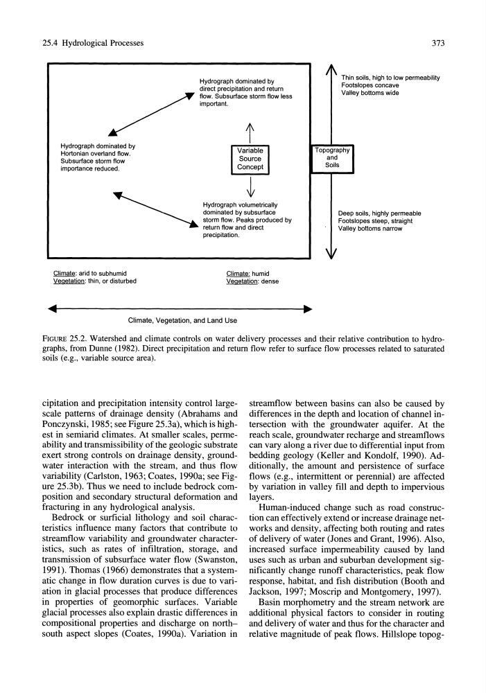
FIGURE 25.2. Watershed and climate controls on water delivery processes and their relative contribution to hydrographs, from Dunne (1982). Direct precipitation and return flow refer to surface flow processes related to saturated
soils (e.g., variable source area).
cipitation and precipitation intensity control largescale patterns of drainage density (Abrahams and
Ponczynski, 1985; see Figure 25.3a), which is highest in semiarid climates. At smaller scales, permeability and transmissibility of the geologic substrate
exert strong controls on drainage density, groundwater interaction with the stream, and thus flow
variability (Carlston, 1963; Coates, 1990a; see Figure 25.3b). Thus we need to include bedrock composition and secondary structural deformation and
fracturing in any hydrological analysis.
Bedrock or surficial lithology and soil characteristics influence many factors that contribute to
streamflow variability and groundwater characteristics, such as rates of infiltration, storage, and
transmission of subsurface water flow (Swanston,
1991). Thomas (1966) demonstrates that a systematic change in flow duration curves is due to variation in glacial processes that produce differences
in properties of geomorphic surfaces. Variable
glacial processes also explain drastic differences in
compositional properties and discharge on northsouth aspect slopes (Coates, 1990a). Variation in
streamflow between basins can also be caused by
differences in the depth and location of channel intersection with the groundwater aquifer. At the
reach scale, groundwater recharge and streamflows
can vary along a river due to differential input from
bedding geology (Keller and Kondolf, 1990). Additionally, the amount and persistence of surface
flows (e.g., intermittent or perennial) are affected
by variation in valley fill and depth to impervious
layers.
Human-induced change such as road construction can effectively extend or increase drainage networks and density, affecting both routing and rates
of delivery of water (Jones and Grant, 1996), Also,
increased surface impermeability caused by land
uses such as urban and suburban development significantly change runoff characteristics, peak flow
response, habitat, and fish distribution (Booth and
Jackson, 1997; Moscrip and Montgomery, 1997),
Basin morphometry and the stream network are
additional physical factors to consider in routing
and delivery of water and thus for the character and
relative magnitude of peak flows. Hillslope topog-
373
Hydrograph dominated by
Thin soils, high to low permeability
Footslopes concave
direct precipitation and return
flow. Subsurface storm flow less
important.
Valley bottoms wide
t
Hydrograph dominated by
Hortonian overland flow.
Subsurface storm flow
importance reduced.
Variable
Source
Concept
Topography
and
Soils
t
~
Hydrograph volumetrically
dominated by subsurface
storm flow. Peaks produced by
return flow and direct
precipitation.
Deep soils, highly permeable
Footslopes steep, straight
Valley bottoms narrow
Climate: arid to subhumid
Vegetation: thin, or disturbed
Climate: humid
Vegetation: dense
Climate, Vegetation, and Land Use
FIGURE 25.2. Watershed and climate controls on water delivery processes and their relative contribution to hydrographs, from Dunne (1982). Direct precipitation and return flow refer to surface flow processes related to saturated
soils (e.g., variable source area).
cipitation and precipitation intensity control largescale patterns of drainage density (Abrahams and
Ponczynski, 1985; see Figure 25.3a), which is highest in semiarid climates. At smaller scales, permeability and transmissibility of the geologic substrate
exert strong controls on drainage density, groundwater interaction with the stream, and thus flow
variability (Carlston, 1963; Coates, 1990a; see Figure 25.3b). Thus we need to include bedrock composition and secondary structural deformation and
fracturing in any hydrological analysis.
Bedrock or surficial lithology and soil characteristics influence many factors that contribute to
streamflow variability and groundwater characteristics, such as rates of infiltration, storage, and
transmission of subsurface water flow (Swanston,
1991). Thomas (1966) demonstrates that a systematic change in flow duration curves is due to variation in glacial processes that produce differences
in properties of geomorphic surfaces. Variable
glacial processes also explain drastic differences in
compositional properties and discharge on northsouth aspect slopes (Coates, 1990a). Variation in
streamflow between basins can also be caused by
differences in the depth and location of channel intersection with the groundwater aquifer. At the
reach scale, groundwater recharge and streamflows
can vary along a river due to differential input from
bedding geology (Keller and Kondolf, 1990). Additionally, the amount and persistence of surface
flows (e.g., intermittent or perennial) are affected
by variation in valley fill and depth to impervious
layers.
Human-induced change such as road construction can effectively extend or increase drainage networks and density, affecting both routing and rates
of delivery of water (Jones and Grant, 1996), Also,
increased surface impermeability caused by land
uses such as urban and suburban development significantly change runoff characteristics, peak flow
response, habitat, and fish distribution (Booth and
Jackson, 1997; Moscrip and Montgomery, 1997),
Basin morphometry and the stream network are
additional physical factors to consider in routing
and delivery of water and thus for the character and
relative magnitude of peak flows. Hillslope topog-