

354
Ecological Classification and Mapping of Aquatic Systems
Nearctic Zone (North America)
I
Surface-water
Geoclimatic
Groundwater
Systems
Setting
System
Subzones
I
Domains
I
Regions
I
Divisions
I
Subregions
I
Provinces ~--River Basins I I
Sections
I
Subbasins
r---I Subsections I
Watersheds I
Subwatersheds
r--Landtypes r---, Aquifers
II Lake Zones H
Stream
Landtype
~---I
Aquifer
Reaches
Phases
Zones
Channel II Lake Sites I
I
Aquifer
Units
Sites
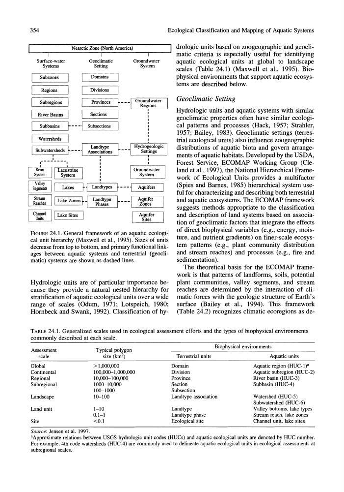
FIGURE 24.1. General framework of an aquatic ecological unit hierarchy (Maxwell et aI., 1995). Sizes of units
decrease from top to bottom, and primary functional linkages between aquatic systems and terrestrial (geoclimatic) systems are shown as dashed lines.
Hydrologic units are of particular importance because they provide a natural nested hierarchy for
stratification of aquatic ecological units over a wide
range of scales (Odum, 1971; Lotspeich, 1980;
Hornbeck and Swank, 1992). Classification of hydrologic units based on zoogeographic and geoclimatic criteria is especially useful for identifying
aquatic ecological units at global to landscape
scales (Table 24.1) (Maxwell et aI., 1995). Biophysical environments that support aquatic ecosystems are described below.
Geoclimatic Setting
Hydrologic units and aquatic systems with similar
geoclimatic properties often have similar ecological patterns and processes (Hack, 1957; Strahler,
1957; Bailey, 1983). Geoclimatic settings (terrestrial ecological units) also influence zoogeographic
distributions of aquatic biota and govern arrangements of aquatic habitats. Developed by the USDA,
Forest Service, ECOMAP Working Group (Cleland et al., 1997), the National Hierarchical Framework of Ecological Units provides a multifactor
(Spies and Barnes, 1985) hierarchical system useful for characterizing and describing both terrestrial
and aquatic ecosystems. The ECOMAP framework
suggests methods appropriate to the classification
and description of land systems based on association of geoclimatic factors that integrate the effects
of direct biophysical variables (e.g., energy, moisture, and nutrient gradients) on finer-scale ecosystem patterns (e.g., plant community distribution
and stream reaches) and processes (e.g., fire and
sedimentation) .
The theoretical basis for the ECOMAP framework is that patterns of landforms, soils, potential
plant communities, valley segments, and stream
reaches are determined by the interaction of climatic forces with the geologic structure of Earth's
surface (Bailey et aI., 1994). This framework
(Table 24.2) recognizes climatic ecoregions as deTABLE 24.1. Generalized scales used in ecological assessment efforts and the types of biophysical environments
commonly described at each scale.
Assessment
Typical polygon
Biophysical environments
scale
size (lan 2 )
Terrestrial units
Aquatic units
Global
>1,000,000
Domain
Aquatic region (HUC-l)a
Continental
100,000-1.000,000
Division
Aquatic subregion (HUC-2)
Regional
10,000-100,000
Province
River basin (HUC-3)
Subregional
1000-10,000
Section
Subbasin (HUC-4)
100-1000
Subsection
Landscape
10-100
Landtype association
Watershed (HUC-5)
Subwatershed (HUC-6)
Land unit
1-10
Landtype
Valley bottoms, lake types
0.1-1
Landtype phase
Stream reach, lake zones
Site
<0.1
Ecological site
Channel unit, lake sites
Source: Jensen et al. 1997.
aApproximate relations between USGS hydrologic unit codes (HUCs) and aquatic ecological units are denoted by HUC number.
For example, 4th code watersheds (HUC-4) are commonly used to delineate aquatic ecological units in ecological assessments at
subregional scales.
Ecological Classification and Mapping of Aquatic Systems
Nearctic Zone (North America)
I
Surface-water
Geoclimatic
Groundwater
Systems
Setting
System
Subzones
I
Domains
I
Regions
I
Divisions
I
Subregions
I
Provinces ~--River Basins I I
Sections
I
Subbasins
r---I Subsections I
Watersheds I
Subwatersheds
r--Landtypes r---, Aquifers
II Lake Zones H
Stream
Landtype
~---I
Aquifer
Reaches
Phases
Zones
Channel II Lake Sites I
I
Aquifer
Units
Sites
FIGURE 24.1. General framework of an aquatic ecological unit hierarchy (Maxwell et aI., 1995). Sizes of units
decrease from top to bottom, and primary functional linkages between aquatic systems and terrestrial (geoclimatic) systems are shown as dashed lines.
Hydrologic units are of particular importance because they provide a natural nested hierarchy for
stratification of aquatic ecological units over a wide
range of scales (Odum, 1971; Lotspeich, 1980;
Hornbeck and Swank, 1992). Classification of hydrologic units based on zoogeographic and geoclimatic criteria is especially useful for identifying
aquatic ecological units at global to landscape
scales (Table 24.1) (Maxwell et aI., 1995). Biophysical environments that support aquatic ecosystems are described below.
Geoclimatic Setting
Hydrologic units and aquatic systems with similar
geoclimatic properties often have similar ecological patterns and processes (Hack, 1957; Strahler,
1957; Bailey, 1983). Geoclimatic settings (terrestrial ecological units) also influence zoogeographic
distributions of aquatic biota and govern arrangements of aquatic habitats. Developed by the USDA,
Forest Service, ECOMAP Working Group (Cleland et al., 1997), the National Hierarchical Framework of Ecological Units provides a multifactor
(Spies and Barnes, 1985) hierarchical system useful for characterizing and describing both terrestrial
and aquatic ecosystems. The ECOMAP framework
suggests methods appropriate to the classification
and description of land systems based on association of geoclimatic factors that integrate the effects
of direct biophysical variables (e.g., energy, moisture, and nutrient gradients) on finer-scale ecosystem patterns (e.g., plant community distribution
and stream reaches) and processes (e.g., fire and
sedimentation) .
The theoretical basis for the ECOMAP framework is that patterns of landforms, soils, potential
plant communities, valley segments, and stream
reaches are determined by the interaction of climatic forces with the geologic structure of Earth's
surface (Bailey et aI., 1994). This framework
(Table 24.2) recognizes climatic ecoregions as deTABLE 24.1. Generalized scales used in ecological assessment efforts and the types of biophysical environments
commonly described at each scale.
Assessment
Typical polygon
Biophysical environments
scale
size (lan 2 )
Terrestrial units
Aquatic units
Global
>1,000,000
Domain
Aquatic region (HUC-l)a
Continental
100,000-1.000,000
Division
Aquatic subregion (HUC-2)
Regional
10,000-100,000
Province
River basin (HUC-3)
Subregional
1000-10,000
Section
Subbasin (HUC-4)
100-1000
Subsection
Landscape
10-100
Landtype association
Watershed (HUC-5)
Subwatershed (HUC-6)
Land unit
1-10
Landtype
Valley bottoms, lake types
0.1-1
Landtype phase
Stream reach, lake zones
Site
<0.1
Ecological site
Channel unit, lake sites
Source: Jensen et al. 1997.
aApproximate relations between USGS hydrologic unit codes (HUCs) and aquatic ecological units are denoted by HUC number.
For example, 4th code watersheds (HUC-4) are commonly used to delineate aquatic ecological units in ecological assessments at
subregional scales.