

344
Dynamic Terrestrial Ecosystem Patterns and Processes
Year
Fires
Attribute Distributions
23.5 .1 Using Historical Data
1953
1941
1937
1934
1923
1921
a
~
iL
..;, -==? z 'otoN"
\:::J iL
Intensity
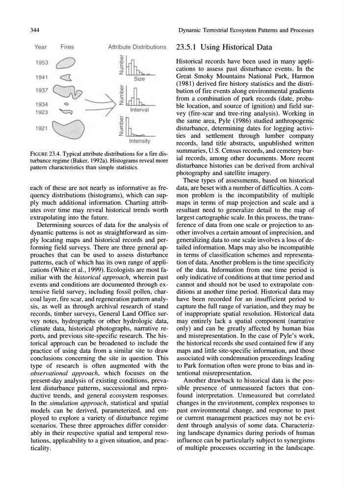
FIGURE 23.4. Typical attribute distributions for a fire disturbance regime (Baker, 1992a). Histograms reveal more
pattern characteristics than simple statistics.
each of these are not nearly as informative as frequency distributions (histograms), which can supply much additional information. Charting attributes over time may reveal historical trends worth
extrapolating into the future.
Determining sources of data for the analysis of
dynamic patterns is not as straightforward as simply locating maps and historical records and performing field surveys. There are three general approaches that can be used to assess disturbance
patterns, each of which has its own range of applications (White et aI., 1999). Ecologists are most familiar with the historical approach, wherein past
events and conditions are documented through extensive field survey, including fossil pollen, charcoal layer, fire scar, and regeneration pattern analysis, as well as through archival research of stand
records, timber surveys, General Land Office survey notes, hydro graphs or other hydrologic data,
climate data, historical photographs, narrative reports, and previous site-specific research. The historical approach can be broadened to include the
practice of using data from a similar site to draw
conclusions concerning the site in question. This
type of research is often augmented with the
observational approach, which focuses on the
present-day analysis of existing conditions, prevalent disturbance patterns, successional and reproductive trends, and general ecosystem responses.
In the simulation approach, statistical and spatial
models can be derived, parameterized, and employed to explore a variety of disturbance regime
scenarios. These three approaches differ considerably in their respective spatial and temporal resolutions, applicability to a given situation, and practicality.
Historical records have been used in many applications to assess past disturbance events. In the
Great Smoky Mountains National Park, Harmon
(1981) derived fire history statistics and the distribution of fire events along environmental gradients
from a combination of park records (date, probable location, and source of ignition) and field survey (fire-scar and tree-ring analysis). Working in
the same area, Pyle (1986) studied anthropogenic
disturbance, determining dates for logging activities and settlement through lumber company
records, land title abstracts, unpublished written
summaries, U.S. Census records, and cemetery burial records, among other documents. More recent
disturbance histories can be derived from archival
photography and satellite imagery.
These types of assessments, based on historical
data, are beset with a number of difficulties. A common problem is the incompatibility of multiple
maps in terms of map projection and scale and a
resultant need to generalize detail to the map of
largest cartographic scale. In this process, the transference of data from one scale or projection to another involves a certain amount of imprecision, and
generalizing data to one scale involves a loss of detailed information. Maps may also be incompatible
in terms of classification schemes and representation of data. Another problem is the time specificity
of the data. Information from one time period is
only indicative of conditions at that time period and
cannot and should not be used to extrapolate conditions at another time period. Historical data may
have been recorded for an insufficient period to
capture the full range of variation, and they may be
of inappropriate spatial resolution. Historical data
may entirely lack a spatial component (narrative
only) and can be greatly affected by human bias
and misrepresentation. In the case of Pyle's work,
the historical records she used contained few if any
maps and little site-specific information, and those
associated with condemnation proceedings leading
to Park formation often were prone to bias and intentional misrepresentation.
Another drawback to historical data is the possible presence of unmeasured factors that confound interpretation. Unmeasured but correlated
changes in the environment, complex responses to
past environmental change, and response to past
or current management practices may not be evident through analysis of some data. Characterizing landscape dynamics during periods of human
influence can be particularly subject to synergisms
of multiple processes occurring in the landscape.
Dynamic Terrestrial Ecosystem Patterns and Processes
Year
Fires
Attribute Distributions
23.5 .1 Using Historical Data
1953
1941
1937
1934
1923
1921
a
~
iL
..;, -==? z 'otoN"
\:::J iL
Intensity
FIGURE 23.4. Typical attribute distributions for a fire disturbance regime (Baker, 1992a). Histograms reveal more
pattern characteristics than simple statistics.
each of these are not nearly as informative as frequency distributions (histograms), which can supply much additional information. Charting attributes over time may reveal historical trends worth
extrapolating into the future.
Determining sources of data for the analysis of
dynamic patterns is not as straightforward as simply locating maps and historical records and performing field surveys. There are three general approaches that can be used to assess disturbance
patterns, each of which has its own range of applications (White et aI., 1999). Ecologists are most familiar with the historical approach, wherein past
events and conditions are documented through extensive field survey, including fossil pollen, charcoal layer, fire scar, and regeneration pattern analysis, as well as through archival research of stand
records, timber surveys, General Land Office survey notes, hydro graphs or other hydrologic data,
climate data, historical photographs, narrative reports, and previous site-specific research. The historical approach can be broadened to include the
practice of using data from a similar site to draw
conclusions concerning the site in question. This
type of research is often augmented with the
observational approach, which focuses on the
present-day analysis of existing conditions, prevalent disturbance patterns, successional and reproductive trends, and general ecosystem responses.
In the simulation approach, statistical and spatial
models can be derived, parameterized, and employed to explore a variety of disturbance regime
scenarios. These three approaches differ considerably in their respective spatial and temporal resolutions, applicability to a given situation, and practicality.
Historical records have been used in many applications to assess past disturbance events. In the
Great Smoky Mountains National Park, Harmon
(1981) derived fire history statistics and the distribution of fire events along environmental gradients
from a combination of park records (date, probable location, and source of ignition) and field survey (fire-scar and tree-ring analysis). Working in
the same area, Pyle (1986) studied anthropogenic
disturbance, determining dates for logging activities and settlement through lumber company
records, land title abstracts, unpublished written
summaries, U.S. Census records, and cemetery burial records, among other documents. More recent
disturbance histories can be derived from archival
photography and satellite imagery.
These types of assessments, based on historical
data, are beset with a number of difficulties. A common problem is the incompatibility of multiple
maps in terms of map projection and scale and a
resultant need to generalize detail to the map of
largest cartographic scale. In this process, the transference of data from one scale or projection to another involves a certain amount of imprecision, and
generalizing data to one scale involves a loss of detailed information. Maps may also be incompatible
in terms of classification schemes and representation of data. Another problem is the time specificity
of the data. Information from one time period is
only indicative of conditions at that time period and
cannot and should not be used to extrapolate conditions at another time period. Historical data may
have been recorded for an insufficient period to
capture the full range of variation, and they may be
of inappropriate spatial resolution. Historical data
may entirely lack a spatial component (narrative
only) and can be greatly affected by human bias
and misrepresentation. In the case of Pyle's work,
the historical records she used contained few if any
maps and little site-specific information, and those
associated with condemnation proceedings leading
to Park formation often were prone to bias and intentional misrepresentation.
Another drawback to historical data is the possible presence of unmeasured factors that confound interpretation. Unmeasured but correlated
changes in the environment, complex responses to
past environmental change, and response to past
or current management practices may not be evident through analysis of some data. Characterizing landscape dynamics during periods of human
influence can be particularly subject to synergisms
of multiple processes occurring in the landscape.