

340
10 g r-----~------------------------~
Global classifications ~
o
Remote sensing, spatial statistics,
Hentage Program records
106
~
SPATIAL SCALE (meters2)
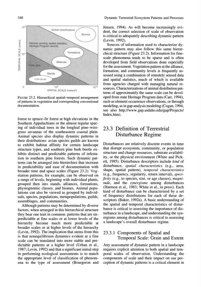
FIGURE 23.2. Hierarchical spatial-temporal arrangement
of patterns in vegetation and corresponding conventional
documentation.
forest to spruce-fir forest at high elevations in the
Southern Appalachians or the almost regular spacing of individual trees in the longleaf pine-wiregrass savannas of the southeastern coastal plain.
Animal species also display dynamic patterns in
their distributions: avian species guilds are known
to exhibit habitat affinity for certain landscape
structure types, and southern pine bark beetle exhibits distinct and predictable patterns of infestation in southern pine forests. Such dynamic patterns can be arranged into hierarchies that increase
in predictability and ease of documentation with
broader time and space scales (Figure 23.2). Vegetation patterns, for example, can be observed on
a range of levels, beginning with individual plants,
grouped then into stands, alliances, formations,
physiognomic classes, and biomes. Animal populations can also be viewed as grouped by individuals, species, populations, metapopulations, guilds,
assemblages, and communities.
Although patterns may be determined by diverse
factors, when arranged in this hierarchical structure
they bear one trait in common: patterns that are unpredictable at fine scales or at lower levels of the
hierarchy become much more predictable at
broader scales or at higher levels of the hierarchy
(Levin, 1992). The implication that stems from this
is that nonequilibrium dynamics evident at a fine
scale can be translated into more stable and predictable patterns at a higher level (Urban et aI.,
1987; Levin, 1992) and that a significant initial step
in performing ecological assessments is to match
the appropriate level of classification of phenomena to the type of assessment (Bourgeron and
Dynamic Terrestrial Ecosystem Patterns and Processes
Jensen, 1994). As will become increasingly evident, the correct selection of scale of observation
is critical to adequately describing dynamic pattern
(Levin, 1992).
Sources of information used to characterize dynamic pattern may also follow this same hierarchical structure (Figure 23.2). Information for finescale phenomena tends to be sparse and is often
developed from field observations done especially
for the assessment. Vegetation pattern at the alliance,
formation, and community levels is frequently assessed using a combination of remotely sensed data
and spatial statistics, much of which is available
from agencies charged with managing natural resources. Characterizations of animal distribution patterns of approximately the same scale can be developed from state Heritage Program data (Carr, 1994),
such as element occurrence observations, or through
modeling, as in gap analysis modeling (Cogan, 1994;
see also http://www.gap.uidaho.edu/gap/Projects/
Index.htm).
23.3 Definition of Terrestrial
Disturbance Regime
Disturbances are relatively discrete events in time
that disrupt ecosystem, community, or population
structure and change resources, substrate availability, or the physical environment (White and Pickett, 1985). Disturbance descriptors include kind of
disturbance, spatial characteristics (e.g., area,
shape, spatial pattern), temporal characteristics
(e.g., frequency, regularity, return interval), specificity (e.g., to species, size, or age classes), magnitude, and the synergisms among disturbances
(Harmon et aI., 1983; White et aI., in press). Each
kind of disturbance can be characterized by a set
of frequency distributions for each of these descriptors (Baker, 1992a). A basic understanding of
the spatial and temporal characteristics of disturbance is critical to assessing the importance of disturbance in a landscape, and understanding the synergisms among disturbances is critical to assessing
a landscape's overall disturbance regime.
23.3.1 Components of Spatial and
Temporal Scale: Grain and Extent
Any assessment of dynamic pattern in a landscape
requires explicit attention to both spatial and temporal scales of observation. Understanding the
components of scale and their impact on our perception of dynamic patterns is a critical element in
10 g r-----~------------------------~
Global classifications ~
o
Remote sensing, spatial statistics,
Hentage Program records
106
~
SPATIAL SCALE (meters2)
FIGURE 23.2. Hierarchical spatial-temporal arrangement
of patterns in vegetation and corresponding conventional
documentation.
forest to spruce-fir forest at high elevations in the
Southern Appalachians or the almost regular spacing of individual trees in the longleaf pine-wiregrass savannas of the southeastern coastal plain.
Animal species also display dynamic patterns in
their distributions: avian species guilds are known
to exhibit habitat affinity for certain landscape
structure types, and southern pine bark beetle exhibits distinct and predictable patterns of infestation in southern pine forests. Such dynamic patterns can be arranged into hierarchies that increase
in predictability and ease of documentation with
broader time and space scales (Figure 23.2). Vegetation patterns, for example, can be observed on
a range of levels, beginning with individual plants,
grouped then into stands, alliances, formations,
physiognomic classes, and biomes. Animal populations can also be viewed as grouped by individuals, species, populations, metapopulations, guilds,
assemblages, and communities.
Although patterns may be determined by diverse
factors, when arranged in this hierarchical structure
they bear one trait in common: patterns that are unpredictable at fine scales or at lower levels of the
hierarchy become much more predictable at
broader scales or at higher levels of the hierarchy
(Levin, 1992). The implication that stems from this
is that nonequilibrium dynamics evident at a fine
scale can be translated into more stable and predictable patterns at a higher level (Urban et aI.,
1987; Levin, 1992) and that a significant initial step
in performing ecological assessments is to match
the appropriate level of classification of phenomena to the type of assessment (Bourgeron and
Dynamic Terrestrial Ecosystem Patterns and Processes
Jensen, 1994). As will become increasingly evident, the correct selection of scale of observation
is critical to adequately describing dynamic pattern
(Levin, 1992).
Sources of information used to characterize dynamic pattern may also follow this same hierarchical structure (Figure 23.2). Information for finescale phenomena tends to be sparse and is often
developed from field observations done especially
for the assessment. Vegetation pattern at the alliance,
formation, and community levels is frequently assessed using a combination of remotely sensed data
and spatial statistics, much of which is available
from agencies charged with managing natural resources. Characterizations of animal distribution patterns of approximately the same scale can be developed from state Heritage Program data (Carr, 1994),
such as element occurrence observations, or through
modeling, as in gap analysis modeling (Cogan, 1994;
see also http://www.gap.uidaho.edu/gap/Projects/
Index.htm).
23.3 Definition of Terrestrial
Disturbance Regime
Disturbances are relatively discrete events in time
that disrupt ecosystem, community, or population
structure and change resources, substrate availability, or the physical environment (White and Pickett, 1985). Disturbance descriptors include kind of
disturbance, spatial characteristics (e.g., area,
shape, spatial pattern), temporal characteristics
(e.g., frequency, regularity, return interval), specificity (e.g., to species, size, or age classes), magnitude, and the synergisms among disturbances
(Harmon et aI., 1983; White et aI., in press). Each
kind of disturbance can be characterized by a set
of frequency distributions for each of these descriptors (Baker, 1992a). A basic understanding of
the spatial and temporal characteristics of disturbance is critical to assessing the importance of disturbance in a landscape, and understanding the synergisms among disturbances is critical to assessing
a landscape's overall disturbance regime.
23.3.1 Components of Spatial and
Temporal Scale: Grain and Extent
Any assessment of dynamic pattern in a landscape
requires explicit attention to both spatial and temporal scales of observation. Understanding the
components of scale and their impact on our perception of dynamic patterns is a critical element in