

w
w
0
TABLE
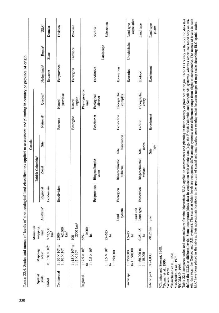
22.4. Scales and names of levels of nine ecological land classifications applied to assessment and planning in country or province of origin.
Spatial
Mapping
scale
scale
Global
<1: 30 X 10 6
Continental
1:30X10 6
to
1:IOX10 6
1: 15 X 10 6
to
1:5x10 6
Regional
1: 7.5 X 10 6
to
1:2.5XI0 6
1: 3.5 X 10 6
to
1: 250,000
Landscape
1: 250,000
to
1 : 50,000
1: 60,000 to
1 :10,000
Site or plot
>24,000
"Christian and Stewart,
1968.
bBanner et al.,
1996.
cWiken,
1979.
dBeauchesne et al.,
1996.
elsachenko et al.,
1973.
IBCOMAP, 1993.
Minimum
mapping
unit
Australia"
Regional
>62,500
Ecodomain
km 2
2500Ecodivision
62,500
km 2
1002500 km 2
62510,000
ha
Ecoprovince
25-625
ha
Land
Ecoregion
system
1.5-25
ha
Land unit
0.25-1.5
Land type
Ecosection
ha
<0.25 ha
Site
Canada
British Columbia b
Zonal
Site
National c
Quebec c
Netherlands d
Russia e
Ecozone
Zone
Ecozone
Natural
Ecoprovince
province
Ecoregion
Natural
Ecoregion
Province
region
Physiographic
unit
Biogeoclimatic
Ecodistrict
Ecological
Ecodistrict
zone
district
Landscape
Biogeoclimatic
Site
Ecosection
Topographic
Ecosection
subzone
association
complex
Ecoseries
Urochishcha
Biogeoclimatic
Site
Ecosite
Topographic
Ecotope
variant
series
entity
Site
Ecoelement
Ecoelement
type
USAf
Domain
Division
Province
Section
Subsection
Land-type
association
Land type
Land-type
phase
Table
22.4 compares scales and nomenclature for nine hierarchical ELCs applied to assessments and planning in
their country or province of origin. These ELCs vary in
the specific data that
define the BLUs at different levels. Some incorporate biotic data in
conjunction with abiotic data (e.g., the British Columbia and Netherlands systems), whereas others are based only on abiotic data (e.g., the Quebec and U.S. systems). The scales at which levels are recognized differ among systems; these differences range from slight to considerable. The names
of levels in each
ELC have been placed in the table at their approximate locations in the spectrum
of spatial and map scales; some overlap exists between ranges of map scales describing ELC spatial scales.
w
0
TABLE
22.4. Scales and names of levels of nine ecological land classifications applied to assessment and planning in country or province of origin.
Spatial
Mapping
scale
scale
Global
<1: 30 X 10 6
Continental
1:30X10 6
to
1:IOX10 6
1: 15 X 10 6
to
1:5x10 6
Regional
1: 7.5 X 10 6
to
1:2.5XI0 6
1: 3.5 X 10 6
to
1: 250,000
Landscape
1: 250,000
to
1 : 50,000
1: 60,000 to
1 :10,000
Site or plot
>24,000
"Christian and Stewart,
1968.
bBanner et al.,
1996.
cWiken,
1979.
dBeauchesne et al.,
1996.
elsachenko et al.,
1973.
IBCOMAP, 1993.
Minimum
mapping
unit
Australia"
Regional
>62,500
Ecodomain
km 2
2500Ecodivision
62,500
km 2
1002500 km 2
62510,000
ha
Ecoprovince
25-625
ha
Land
Ecoregion
system
1.5-25
ha
Land unit
0.25-1.5
Land type
Ecosection
ha
<0.25 ha
Site
Canada
British Columbia b
Zonal
Site
National c
Quebec c
Netherlands d
Russia e
Ecozone
Zone
Ecozone
Natural
Ecoprovince
province
Ecoregion
Natural
Ecoregion
Province
region
Physiographic
unit
Biogeoclimatic
Ecodistrict
Ecological
Ecodistrict
zone
district
Landscape
Biogeoclimatic
Site
Ecosection
Topographic
Ecosection
subzone
association
complex
Ecoseries
Urochishcha
Biogeoclimatic
Site
Ecosite
Topographic
Ecotope
variant
series
entity
Site
Ecoelement
Ecoelement
type
USAf
Domain
Division
Province
Section
Subsection
Land-type
association
Land type
Land-type
phase
Table
22.4 compares scales and nomenclature for nine hierarchical ELCs applied to assessments and planning in
their country or province of origin. These ELCs vary in
the specific data that
define the BLUs at different levels. Some incorporate biotic data in
conjunction with abiotic data (e.g., the British Columbia and Netherlands systems), whereas others are based only on abiotic data (e.g., the Quebec and U.S. systems). The scales at which levels are recognized differ among systems; these differences range from slight to considerable. The names
of levels in each
ELC have been placed in the table at their approximate locations in the spectrum
of spatial and map scales; some overlap exists between ranges of map scales describing ELC spatial scales.