

22.4 Overview of Major Ecological Land Classifications
Condition and
suitability
assessment
Climate
Landform
Soil
Geology
Modeling
landscape,
vegetation,
ecosystem
dynamics
Historical
range of
variability
Modeling biotic
distributions
and responses
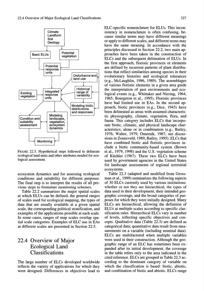
FIGURE 22.3. Hypothetical steps followed to delineate
ecological land units and other attributes needed for ecological assessment.
ecosystem dynamics and for assessing ecological
conditions and suitability for different purposes.
The final step is to interpret the results of all previous steps to formulate monitoring schemes.
Table 22.2 summarizes the major spatial scales
at which ELUs can be defined, the general ranges
of scales used for ecological mapping, the types of
data that are usually available at a given spatial
scale, the corresponding political stratification, and
examples of the applications possible at each scale.
In some cases, ranges of map scales overlap spatial scale categories. Examples of ELC use in EAs
at different scales are presented in Section 22.5.
22.4 Overview of Major
Ecological Land
Classifications
The large number of ELCs developed worldwide
reflects the variety of applications for which they
were designed. Differences in objectives lead to
327
ELC-specific nomenclature for ELUs. This inconsistency in nomenclature is often confusing, because similar terms may have different meanings
or apply to different scales, and different terms may
have the same meaning. In accordance with the
principles discussed in Section 22.2, two main approaches have been taken in the construction of
ELCs and the subsequent delineation of ELUs. In
the first approach, floristic provinces or elements
are defined by recurrent patterns of plant distributions that reflect similarities among species in their
evolutionary histories and ecological tolerances
(e.g., McLaughlin, 1986, 1989). The assemblages
of various floristic elements in a given area guide
the interpretation of past environments and ecological events (e.g., Whittaker and Niering, 1964,
1965; Bourgeron et aI., 1995). Floristic provinces
have had limited use in EAs. In the second approach, biotic provinces (e.g., Dice, 1943) have
been delineated as areas with assumed characteristic physiography, climate, vegetation, flora, and
fauna. This category includes ELCs that incorporate biotic, climatic, and physical landscape characteristics, alone or in combination (e.g., Bailey,
1976; Walter, 1979; Omernik, 1987; see discussions in Zonneveld, 1989; Bailey, 1995). ELCs that
have combined biotic and floristic provinces include a biotic community-based system (Brown
et al., 1979, 1998) and the U.S. vegetation scheme
of Ki.ichler (1967). These two ELCs have been
used by government agencies in the United States
for landscape assessments of regional terrestrial
ecosystems.
Table 22.3 (adapted and modified from Grossman et aI., 1999) summarizes the following aspects
of 30 ELCs currently used by various institutions:
whether or not they are hierarchical, the types of
data used in their development, their intended geographic coverage, and the broad categories of purposes for which they were initially designed. Many
ELCs are hierarchical, allowing the definition of
ELUs at multiple scales according to specific classification rules. Hierarchical ELCs vary in number
of levels, reflecting specific objectives and concepts. Qualitative data (Table 22.3) are defined as
categorical data; quantitative data result from measurements on a variable (including nominal data).
ELCs are multifactored when multiple variables
were used in their construction. Although the geographic range of an ELC has sometimes been expanded after its initial development, the coverage
in the table refers only to the area indicated in the
cited reference. ELCs are grouped in Table 22.3 according to the dominant category of variable on
which the classification is based: biotic, abiotic,
and combination of biotic and abiotic. ELCs range
Condition and
suitability
assessment
Climate
Landform
Soil
Geology
Modeling
landscape,
vegetation,
ecosystem
dynamics
Historical
range of
variability
Modeling biotic
distributions
and responses
FIGURE 22.3. Hypothetical steps followed to delineate
ecological land units and other attributes needed for ecological assessment.
ecosystem dynamics and for assessing ecological
conditions and suitability for different purposes.
The final step is to interpret the results of all previous steps to formulate monitoring schemes.
Table 22.2 summarizes the major spatial scales
at which ELUs can be defined, the general ranges
of scales used for ecological mapping, the types of
data that are usually available at a given spatial
scale, the corresponding political stratification, and
examples of the applications possible at each scale.
In some cases, ranges of map scales overlap spatial scale categories. Examples of ELC use in EAs
at different scales are presented in Section 22.5.
22.4 Overview of Major
Ecological Land
Classifications
The large number of ELCs developed worldwide
reflects the variety of applications for which they
were designed. Differences in objectives lead to
327
ELC-specific nomenclature for ELUs. This inconsistency in nomenclature is often confusing, because similar terms may have different meanings
or apply to different scales, and different terms may
have the same meaning. In accordance with the
principles discussed in Section 22.2, two main approaches have been taken in the construction of
ELCs and the subsequent delineation of ELUs. In
the first approach, floristic provinces or elements
are defined by recurrent patterns of plant distributions that reflect similarities among species in their
evolutionary histories and ecological tolerances
(e.g., McLaughlin, 1986, 1989). The assemblages
of various floristic elements in a given area guide
the interpretation of past environments and ecological events (e.g., Whittaker and Niering, 1964,
1965; Bourgeron et aI., 1995). Floristic provinces
have had limited use in EAs. In the second approach, biotic provinces (e.g., Dice, 1943) have
been delineated as areas with assumed characteristic physiography, climate, vegetation, flora, and
fauna. This category includes ELCs that incorporate biotic, climatic, and physical landscape characteristics, alone or in combination (e.g., Bailey,
1976; Walter, 1979; Omernik, 1987; see discussions in Zonneveld, 1989; Bailey, 1995). ELCs that
have combined biotic and floristic provinces include a biotic community-based system (Brown
et al., 1979, 1998) and the U.S. vegetation scheme
of Ki.ichler (1967). These two ELCs have been
used by government agencies in the United States
for landscape assessments of regional terrestrial
ecosystems.
Table 22.3 (adapted and modified from Grossman et aI., 1999) summarizes the following aspects
of 30 ELCs currently used by various institutions:
whether or not they are hierarchical, the types of
data used in their development, their intended geographic coverage, and the broad categories of purposes for which they were initially designed. Many
ELCs are hierarchical, allowing the definition of
ELUs at multiple scales according to specific classification rules. Hierarchical ELCs vary in number
of levels, reflecting specific objectives and concepts. Qualitative data (Table 22.3) are defined as
categorical data; quantitative data result from measurements on a variable (including nominal data).
ELCs are multifactored when multiple variables
were used in their construction. Although the geographic range of an ELC has sometimes been expanded after its initial development, the coverage
in the table refers only to the area indicated in the
cited reference. ELCs are grouped in Table 22.3 according to the dominant category of variable on
which the classification is based: biotic, abiotic,
and combination of biotic and abiotic. ELCs range