

138
... Oota
Remote Sensing Applied to Ecosystem Management
,~
\
\
Satellite
• Landsat TM
• Landsat MSS
• AVHRR
Low-altitude Aircraft
• onvenlional photo
• Digital Photogr.lphy
• Airborne videography
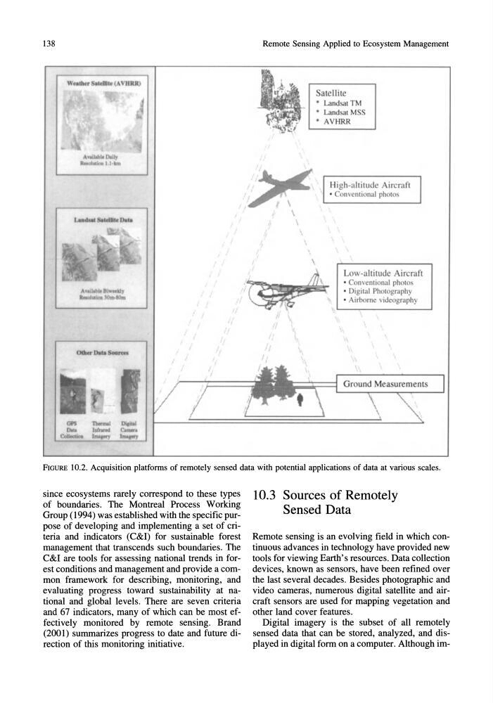
FIGURE 10.2. Acquisition platforms of remotely sensed data with potential applications of data at various scales.
since ecosystems rarely correspond to these types
of boundaries. The Montreal Process Working
Group (1994) was established with the specific purpose of developing and implementing a set of criteria and indicators (C&I) for sustainable forest
management that transcends such boundaries. The
C&I are tools for assessing national trends in forest conditions and management and provide a common framework for describing, monitoring, and
evaluating progress toward sustainability at national and global levels. There are seven criteria
and 67 indicators, many of which can be most effectively monitored by remote sensing. Brand
(2001) summarizes progress to date and future direction of this monitoring initiative.
10.3 Sources of Remotely
Sensed Data
Remote sensing is an evolving field in which continuous advances in technology have provided new
tools for viewing Earth's resources. Data collection
devices, known as sensors, have been refined over
the last several decades. Besides photographic and
video cameras, numerous digital satellite and aircraft sensors are used for mapping vegetation and
other land cover features.
Digital imagery is the subset of all remotely
sensed data that can be stored, analyzed, and displayed in digital form on a computer. Although im-
... Oota
Remote Sensing Applied to Ecosystem Management
,~
\
\
Satellite
• Landsat TM
• Landsat MSS
• AVHRR
Low-altitude Aircraft
• onvenlional photo
• Digital Photogr.lphy
• Airborne videography
FIGURE 10.2. Acquisition platforms of remotely sensed data with potential applications of data at various scales.
since ecosystems rarely correspond to these types
of boundaries. The Montreal Process Working
Group (1994) was established with the specific purpose of developing and implementing a set of criteria and indicators (C&I) for sustainable forest
management that transcends such boundaries. The
C&I are tools for assessing national trends in forest conditions and management and provide a common framework for describing, monitoring, and
evaluating progress toward sustainability at national and global levels. There are seven criteria
and 67 indicators, many of which can be most effectively monitored by remote sensing. Brand
(2001) summarizes progress to date and future direction of this monitoring initiative.
10.3 Sources of Remotely
Sensed Data
Remote sensing is an evolving field in which continuous advances in technology have provided new
tools for viewing Earth's resources. Data collection
devices, known as sensors, have been refined over
the last several decades. Besides photographic and
video cameras, numerous digital satellite and aircraft sensors are used for mapping vegetation and
other land cover features.
Digital imagery is the subset of all remotely
sensed data that can be stored, analyzed, and displayed in digital form on a computer. Although im-