

116
Ecological Data Storage, Management, and Dissemination
/-------.......-.....
/1MAGERY.M.Q.lm. '\
( Attributes: Services: \)
I, position
read
/
columns
display ~
~
',Jows
n'
, , /
~
/~~;~~'\ ' --r-- /I~=~'
(
Attributes:
\
" - -
- _
i Attributes: \)
Bandt Band2 ... Band7: i
/ '
~',
,Bandt, Band2, ... , BandS:
\
'
"
/
/ IMAGERY.M2m\
\
, '/
I
Attributes:
\
~ -
l{3andl, Band2, ... , Ban~>'
L.::I
--,
~ Class I Subclass )
'_ /
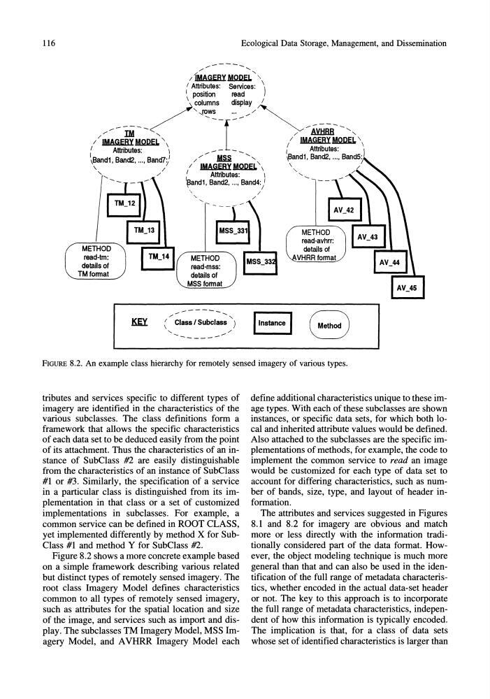
-----FIGURE 8.2. An example class hierarchy for remotely sensed imagery of various types.
tributes and services specific to different types of
imagery are identified in the characteristics of the
various subclasses. The class definitions form a
framework that allows the specific characteristics
of each data set to be deduced easily from the point
of its attachment. Thus the characteristics of an instance of SubClass #2 are easily distinguishable
from the characteristics of an instance of SubClass
#1 or #3. Similarly, the specification of a service
in a particular class is distinguished from its implementation in that class or a set of customized
implementations in subclasses. For example, a
common service can be defined in ROOT CLASS,
yet implemented differently by method X for SubClass #1 and method Y for SubClass #2.
Figure 8.2 shows a more concrete example based
on a simple framework describing various related
but distinct types of remotely sensed imagery. The
root class Imagery Model defines characteristics
common to all types of remotely sensed imagery,
such as attributes for the spatial location and size
of the image, and services such as import and display. The subclasses TM Imagery Model, MSS Imagery Model, and A VHRR Imagery Model each
define additional characteristics unique to these image types. With each of these subclasses are shown
instances, or specific data sets, for which both local and inherited attribute values would be defined.
Also attached to the subclasses are the specific implementations of methods, for example, the code to
implement the common service to read an image
would be customized for each type of data set to
account for differing characteristics, such as number of bands, size, type, and layout of header information.
The attributes and services suggested in Figures
8.1 and 8.2 for imagery are obvious and match
more or less directly with the information traditionally considered part of the data format. However, the object modeling technique is much more
general than that and can also be used in the identification of the full range of metadata characteristics, whether encoded in the actual data-set header
or not. The key to this approach is to incorporate
the full range of metadata characteristics, independent of how this information is typically encoded.
The implication is that, for a class of data sets
whose set of identified characteristics is larger than
Ecological Data Storage, Management, and Dissemination
/-------.......-.....
/1MAGERY.M.Q.lm. '\
( Attributes: Services: \)
I, position
read
/
columns
display ~
~
',Jows
n'
, , /
~
/~~;~~'\ ' --r-- /I~=~'
(
Attributes:
\
" - -
- _
i Attributes: \)
Bandt Band2 ... Band7: i
/ '
~',
,Bandt, Band2, ... , BandS:
\
'
"
/
/ IMAGERY.M2m\
\
, '/
I
Attributes:
\
~ -
l{3andl, Band2, ... , Ban~>'
L.::I
--,
~ Class I Subclass )
'_ /
-----FIGURE 8.2. An example class hierarchy for remotely sensed imagery of various types.
tributes and services specific to different types of
imagery are identified in the characteristics of the
various subclasses. The class definitions form a
framework that allows the specific characteristics
of each data set to be deduced easily from the point
of its attachment. Thus the characteristics of an instance of SubClass #2 are easily distinguishable
from the characteristics of an instance of SubClass
#1 or #3. Similarly, the specification of a service
in a particular class is distinguished from its implementation in that class or a set of customized
implementations in subclasses. For example, a
common service can be defined in ROOT CLASS,
yet implemented differently by method X for SubClass #1 and method Y for SubClass #2.
Figure 8.2 shows a more concrete example based
on a simple framework describing various related
but distinct types of remotely sensed imagery. The
root class Imagery Model defines characteristics
common to all types of remotely sensed imagery,
such as attributes for the spatial location and size
of the image, and services such as import and display. The subclasses TM Imagery Model, MSS Imagery Model, and A VHRR Imagery Model each
define additional characteristics unique to these image types. With each of these subclasses are shown
instances, or specific data sets, for which both local and inherited attribute values would be defined.
Also attached to the subclasses are the specific implementations of methods, for example, the code to
implement the common service to read an image
would be customized for each type of data set to
account for differing characteristics, such as number of bands, size, type, and layout of header information.
The attributes and services suggested in Figures
8.1 and 8.2 for imagery are obvious and match
more or less directly with the information traditionally considered part of the data format. However, the object modeling technique is much more
general than that and can also be used in the identification of the full range of metadata characteristics, whether encoded in the actual data-set header
or not. The key to this approach is to incorporate
the full range of metadata characteristics, independent of how this information is typically encoded.
The implication is that, for a class of data sets
whose set of identified characteristics is larger than