

11.4 The Toolkit and Environmental Management
Discussions of the structure of the toolkit and its contents benefit from considering the nature of specific resource management decisions and how
such decisions are actually made. Such consideration further benefits from
insights provided by those resource managers who participate in toolkit
development.
216
Steven M. Bartell
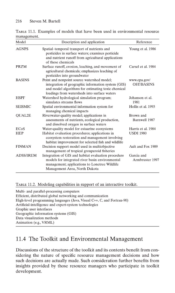
Table 11.1. Examples of models that have been used in environmental resource
management.
Model
Description and application
Reference
AGNPS
Spatial–temporal transport of nutrients and
Young et al. 1986
pesticides in surface waters; examines pesticide
and nutrient runoff from agricultural applications
of these chemicals
PRZM
Surface runoff, erosion, leaching, and movement of
Carsel et al. 1984
agricultural chemicals; emphasizes leaching of
pesticides into groundwater
BASINS
Point and nonpoint source watershed model;
www.epa.gov/
integration of geographic information system (GIS)
OST/BASINS
and model algorithms for estimating toxic chemical
loadings from watersheds into surface waters
HSPF
Watershed hydrological simulation program;
Johanson et al.
simulates streams flows
1981
SEISMIC
Spatial environmental information system for
Hollis et al. 1993
managing chemical impacts
QUAL2E
Riverwater-quality model; applications in
Brown and
assessments of nutrients, ecological production,
Barnwell 1987
and dissolved oxygen in surface waters
ECoS
Water-quality model for estuarine ecosystems
Harris et al. 1984
HEP
Habitat evaluation procedures; applications in
USDI 1980
ecosystem restoration and management involving
habitat improvement for selected fish and wildlife
FINMAN
Decision support model used in multiobjective
Ault and Fox 1989
management of tropical grouperoid fisheries
ADSS/IREM
Integration of GIS and habitat evaluation procedure Garcia and
models for integrated river basin environmental
Armbruster 1997
management; applications to Lonetree Wildlife
Management Area, North Dakota
Table 11.2. Modeling capabilities in support of an interactive toolkit.
Multi- and parallel-processing computers
Efficient, distributed global networking and communication
High-level programming languages (Java, Visual C++, C, and Fortran-90)
Artificial-intelligence and expert-system technologies
Graphic user interfaces
Geographic information systems (GIS)
Data visualization methods
Animation (e.g., VRML)
Discussions of the structure of the toolkit and its contents benefit from considering the nature of specific resource management decisions and how
such decisions are actually made. Such consideration further benefits from
insights provided by those resource managers who participate in toolkit
development.
216
Steven M. Bartell
Table 11.1. Examples of models that have been used in environmental resource
management.
Model
Description and application
Reference
AGNPS
Spatial–temporal transport of nutrients and
Young et al. 1986
pesticides in surface waters; examines pesticide
and nutrient runoff from agricultural applications
of these chemicals
PRZM
Surface runoff, erosion, leaching, and movement of
Carsel et al. 1984
agricultural chemicals; emphasizes leaching of
pesticides into groundwater
BASINS
Point and nonpoint source watershed model;
www.epa.gov/
integration of geographic information system (GIS)
OST/BASINS
and model algorithms for estimating toxic chemical
loadings from watersheds into surface waters
HSPF
Watershed hydrological simulation program;
Johanson et al.
simulates streams flows
1981
SEISMIC
Spatial environmental information system for
Hollis et al. 1993
managing chemical impacts
QUAL2E
Riverwater-quality model; applications in
Brown and
assessments of nutrients, ecological production,
Barnwell 1987
and dissolved oxygen in surface waters
ECoS
Water-quality model for estuarine ecosystems
Harris et al. 1984
HEP
Habitat evaluation procedures; applications in
USDI 1980
ecosystem restoration and management involving
habitat improvement for selected fish and wildlife
FINMAN
Decision support model used in multiobjective
Ault and Fox 1989
management of tropical grouperoid fisheries
ADSS/IREM
Integration of GIS and habitat evaluation procedure Garcia and
models for integrated river basin environmental
Armbruster 1997
management; applications to Lonetree Wildlife
Management Area, North Dakota
Table 11.2. Modeling capabilities in support of an interactive toolkit.
Multi- and parallel-processing computers
Efficient, distributed global networking and communication
High-level programming languages (Java, Visual C++, C, and Fortran-90)
Artificial-intelligence and expert-system technologies
Graphic user interfaces
Geographic information systems (GIS)
Data visualization methods
Animation (e.g., VRML)