

252
R.R. Twilley et a!.
linson 1986) do not cite the species for the Pacific coast of South America.
The dominant mangrove in the Gulf of Guayaquil is Rhizophora harrisonii
followed by R. mangle. Avicennia germinans (L.), Laguncularia racemosa
(L.) Gaertn., and Conocarpus erectus (L.) occur in less frequently inundated regions of the intertidal zone. Other vegetation in salinas includes Salicornia fruticosa (L.), May tenus octogona, Acrostichum aureum, Cryptocarpus pyriformis, and Batis maritima (L.). Owing to the construction of
shrimp ponds (147,978 ha in 1995) and urban expansion along the shore of
Estero Salado, mangrove areas in the Gulf of Guayaquil and Guayas River
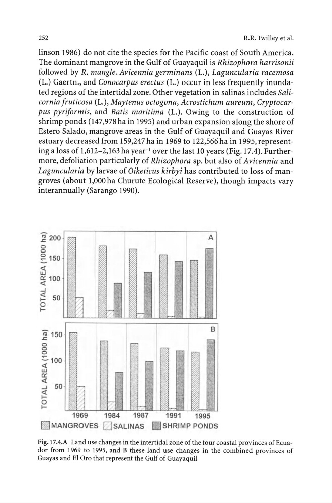
estuary decreased from 159,247 ha in 1969 to 122,566 ha in 1995, representing a loss of 1,612-2,163 ha year-' over the last 10 years (Fig. 17.4). Furthermore, defoliation particularly of Rhizophora sp. but also of Avicennia and
Laguncularia by larvae of Oiketicus kirbyi has contributed to loss of mangroves (about 1,000 ha Churute Ecological Reserve), though impacts vary
interannually (Sarango 1990).
(il200 .r:;
0
0
~ 150
- <(
LU
0:: 100
<(
...J
~ 50
0
I"iil150 .r:;
0
0
0
~100
<(
LU
0::
<(
...J
50
<(
to
IA
1969
1984
1987
1991
1995
l§'l MANGROVEs OsAUNAS DsHRIMP PONDS
Fig.l7.4.A Land use changes in the intertidal zone of the four coastal provinces of Ecuador from 1969 to 1995, and B these land use changes in the combined provinces of
Guayas and El Oro that represent the Gulf of Guayaquil
R.R. Twilley et a!.
linson 1986) do not cite the species for the Pacific coast of South America.
The dominant mangrove in the Gulf of Guayaquil is Rhizophora harrisonii
followed by R. mangle. Avicennia germinans (L.), Laguncularia racemosa
(L.) Gaertn., and Conocarpus erectus (L.) occur in less frequently inundated regions of the intertidal zone. Other vegetation in salinas includes Salicornia fruticosa (L.), May tenus octogona, Acrostichum aureum, Cryptocarpus pyriformis, and Batis maritima (L.). Owing to the construction of
shrimp ponds (147,978 ha in 1995) and urban expansion along the shore of
Estero Salado, mangrove areas in the Gulf of Guayaquil and Guayas River
estuary decreased from 159,247 ha in 1969 to 122,566 ha in 1995, representing a loss of 1,612-2,163 ha year-' over the last 10 years (Fig. 17.4). Furthermore, defoliation particularly of Rhizophora sp. but also of Avicennia and
Laguncularia by larvae of Oiketicus kirbyi has contributed to loss of mangroves (about 1,000 ha Churute Ecological Reserve), though impacts vary
interannually (Sarango 1990).
(il200 .r:;
0
0
~ 150
- <(
LU
0:: 100
<(
...J
~ 50
0
I"iil150 .r:;
0
0
0
~100
<(
LU
0::
<(
...J
50
<(
to
IA
1969
1984
1987
1991
1995
l§'l MANGROVEs OsAUNAS DsHRIMP PONDS
Fig.l7.4.A Land use changes in the intertidal zone of the four coastal provinces of Ecuador from 1969 to 1995, and B these land use changes in the combined provinces of
Guayas and El Oro that represent the Gulf of Guayaquil