

76
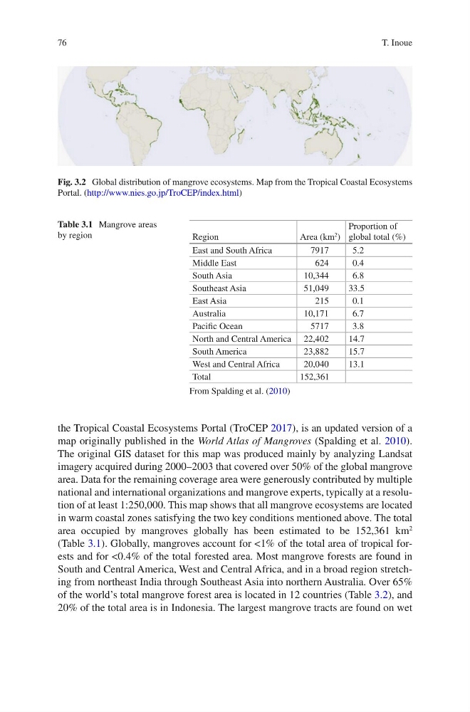
the Tropical Coastal Ecosystems Portal (TroCEP 2017), is an updated version of a
map originally published in the World Atlas of Mangroves (Spalding et al. 2010).
The original GIS dataset for this map was produced mainly by analyzing Landsat
imagery acquired during 2000–2003 that covered over 50% of the global mangrove
area. Data for the remaining coverage area were generously contributed by multiple
national and international organizations and mangrove experts, typically at a resolution of at least 1:250,000. This map shows that all mangrove ecosystems are located
in warm coastal zones satisfying the two key conditions mentioned above. The total
area occupied by mangroves globally has been estimated to be 152,361 km
2
(Table 3.1). Globally, mangroves account for <1% of the total area of tropical forests and for <0.4% of the total forested area. Most mangrove forests are found in
South and Central America, West and Central Africa, and in a broad region stretching from northeast India through Southeast Asia into northern Australia. Over 65%
of the world’s total mangrove forest area is located in 12 countries (Table 3.2), and
20% of the total area is in Indonesia. The largest mangrove tracts are found on wet
Fig. 3.2 Global distribution of mangrove ecosystems. Map from the Tropical Coastal Ecosystems
Portal. (http://www.nies.go.jp/TroCEP/index.html)
Table 3.1 Mangrove areas
by region
Region
Area (km
2
)
Proportion of
global total (%)
East and South Africa
7917
5.2
Middle East
624
0.4
South Asia
10,344
6.8
Southeast Asia
51,049
33.5
East Asia
215
0.1
Australia
10,171
6.7
Pacific Ocean
5717
3.8
North and Central America 22,402
14.7
South America
23,882
15.7
West and Central Africa
20,040
13.1
Total
152,361
From Spalding et al. (2010)
T. Inoue
the Tropical Coastal Ecosystems Portal (TroCEP 2017), is an updated version of a
map originally published in the World Atlas of Mangroves (Spalding et al. 2010).
The original GIS dataset for this map was produced mainly by analyzing Landsat
imagery acquired during 2000–2003 that covered over 50% of the global mangrove
area. Data for the remaining coverage area were generously contributed by multiple
national and international organizations and mangrove experts, typically at a resolution of at least 1:250,000. This map shows that all mangrove ecosystems are located
in warm coastal zones satisfying the two key conditions mentioned above. The total
area occupied by mangroves globally has been estimated to be 152,361 km
2
(Table 3.1). Globally, mangroves account for <1% of the total area of tropical forests and for <0.4% of the total forested area. Most mangrove forests are found in
South and Central America, West and Central Africa, and in a broad region stretching from northeast India through Southeast Asia into northern Australia. Over 65%
of the world’s total mangrove forest area is located in 12 countries (Table 3.2), and
20% of the total area is in Indonesia. The largest mangrove tracts are found on wet
Fig. 3.2 Global distribution of mangrove ecosystems. Map from the Tropical Coastal Ecosystems
Portal. (http://www.nies.go.jp/TroCEP/index.html)
Table 3.1 Mangrove areas
by region
Region
Area (km
2
)
Proportion of
global total (%)
East and South Africa
7917
5.2
Middle East
624
0.4
South Asia
10,344
6.8
Southeast Asia
51,049
33.5
East Asia
215
0.1
Australia
10,171
6.7
Pacific Ocean
5717
3.8
North and Central America 22,402
14.7
South America
23,882
15.7
West and Central Africa
20,040
13.1
Total
152,361
From Spalding et al. (2010)
T. Inoue