

46
roads, bridges and dikes, was immediately
evident. However, it was diffi cult to observe
damage to the seagrass and seaweed beds, which
serve as “natural infrastructures” for fi sheries.
Therefore, we opted to survey the seagrass and
seaweed beds in Otsuchi Bay after the tsunami.
In this article, we examine the status of seagrass and seaweed beds before and after the 2011
tsunami to provide information on these beds,
their role in coastal fi sheries and their resilience
to natural catastrophic disasters occurring on the
Sanriku Coast.
2
Materials and Methods
2.1
Study Site
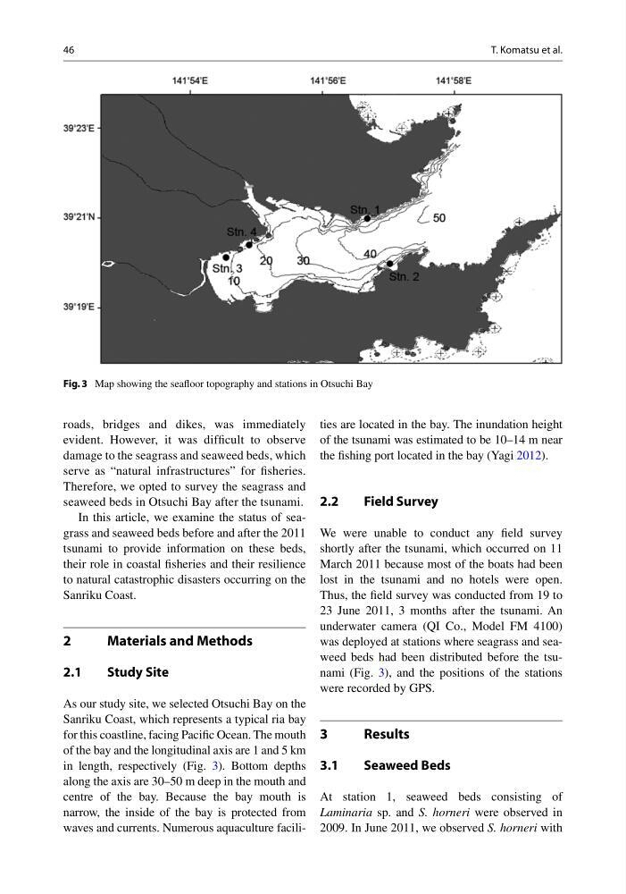
As our study site, we selected Otsuchi Bay on the
Sanriku Coast, which represents a typical ria bay
for this coastline, facing Pacifi c Ocean. The mouth
of the bay and the longitudinal axis are 1 and 5 km
in length, respectively (Fig. 3 ). Bottom depths
along the axis are 30–50 m deep in the mouth and
centre of the bay. Because the bay mouth is
narrow, the inside of the bay is protected from
waves and currents. Numerous aquaculture facilities are located in the bay. The inundation height
of the tsunami was estimated to be 10–14 m near
the fi shing port located in the bay (Yagi 2012 ).
2.2
Field Survey
We were unable to conduct any fi eld survey
shortly after the tsunami, which occurred on 11
March 2011 because most of the boats had been
lost in the tsunami and no hotels were open.
Thus, the fi eld survey was conducted from 19 to
23 June 2011, 3 months after the tsunami. An
underwater camera (QI Co., Model FM 4100)
was deployed at stations where seagrass and seaweed beds had been distributed before the tsunami (Fig. 3 ), and the positions of the stations
were recorded by GPS.
3
Results
3.1
Seaweed Beds
At station 1, seaweed beds consisting of
Laminaria sp. and S. horneri were observed in
2009. In June 2011, we observed S. horneri with
Fig. 3 Map showing the seafl oor topography and stations in Otsuchi Bay
T. Komatsu et al.
roads, bridges and dikes, was immediately
evident. However, it was diffi cult to observe
damage to the seagrass and seaweed beds, which
serve as “natural infrastructures” for fi sheries.
Therefore, we opted to survey the seagrass and
seaweed beds in Otsuchi Bay after the tsunami.
In this article, we examine the status of seagrass and seaweed beds before and after the 2011
tsunami to provide information on these beds,
their role in coastal fi sheries and their resilience
to natural catastrophic disasters occurring on the
Sanriku Coast.
2
Materials and Methods
2.1
Study Site
As our study site, we selected Otsuchi Bay on the
Sanriku Coast, which represents a typical ria bay
for this coastline, facing Pacifi c Ocean. The mouth
of the bay and the longitudinal axis are 1 and 5 km
in length, respectively (Fig. 3 ). Bottom depths
along the axis are 30–50 m deep in the mouth and
centre of the bay. Because the bay mouth is
narrow, the inside of the bay is protected from
waves and currents. Numerous aquaculture facilities are located in the bay. The inundation height
of the tsunami was estimated to be 10–14 m near
the fi shing port located in the bay (Yagi 2012 ).
2.2
Field Survey
We were unable to conduct any fi eld survey
shortly after the tsunami, which occurred on 11
March 2011 because most of the boats had been
lost in the tsunami and no hotels were open.
Thus, the fi eld survey was conducted from 19 to
23 June 2011, 3 months after the tsunami. An
underwater camera (QI Co., Model FM 4100)
was deployed at stations where seagrass and seaweed beds had been distributed before the tsunami (Fig. 3 ), and the positions of the stations
were recorded by GPS.
3
Results
3.1
Seaweed Beds
At station 1, seaweed beds consisting of
Laminaria sp. and S. horneri were observed in
2009. In June 2011, we observed S. horneri with
Fig. 3 Map showing the seafl oor topography and stations in Otsuchi Bay
T. Komatsu et al.