

181
2.3
Explicit Model Coupling
in Practice
Marxan with Zones is a command-line software
which works with text input files, all listed in a
main input file and with fairly simple and documented structures (Watts et al. 2008). It is therefore easily controlled through any platform which
allows running commands and is able to handle
data and text files (e.g., we have easily controlled
all the MwZ analysis sequence, from data formatting to output representation, with R; http://
cran.r-project.org). Principal Marxan input files
which would be subject to dynamical updates are:
• The planning unit file and more particularly
the costs given to each planning unit (PU)
• The features (here exploited species) versus
PU file which gives amount of each feature
within each PU
Files such as those containing boundary
lengths/connectivities between protection units
or “zone boundary costs” pertain to the original
design and are unlikely to be modified by iterative runs (except for sensitivity analysis).
As for ISIS-Fish, control from a third-party
tool seems more difficult since most parameters
are stored in embedded databases, with internal
referencing of objects, as spatial units or populations, for instance. Therefore, even though ISISFish simulations themselves can be run from
command-line calls, the management zones of
the model cannot be directly controlled through
text files. However, ISIS-Fish is an open-source
modeling platform, with an active development
team, hence highly extendable.
For instance, concerning the translation from
MwZ outputs to ISIS-Fish management strategies, the ISIS extensive scripting (Java script)
abilities will be used to:
1. Load formatted MwZ outputs (preferably preprocessed by R scripts for easy handling)
2. Define as many management zones as different effort reductions by gear, calculated from
MwZ outputs (pre-simulation script)
3. Apply for each cell an effort reduction by
métier from its overlap with management
zones for the gear used at each time step
The second point raises the issue of transferring costs, features, and optimized spatial management measures between two possibly different
spatial scales. Indeed, there is no requirement for
the spatial grid in MwZ to be regular, as it is the
case for the one in ISIS-Fish. In fact, it is even
convenient to keep existing – intricately shaped –
MPAs as separated PUs (e.g., Fig. 3) for MwZ
analyses. Therefore, even under simple homogeneity assumption regarding amounts within grid
cells, the transfer of data from a grid to another
requires extensive calculations, among which
assessment of cell surface overlaps between the
two model spatial grid layers (which only needs
to be calculated once) and pro rata reallocation
rates from one grid to the other. This is easily
done with R scripts which can notably calculate
an accurate effort reduction in ISIS spatial unit
(cell) by gear, from a given MwZ solution, since
gear limitations are given for each kind of conservation zone.
As for the automation of the coupling, two
options emerge:
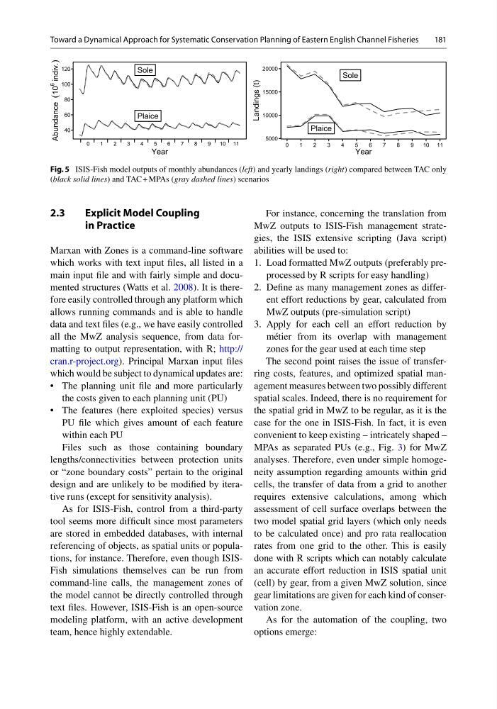
Fig. 5 ISIS-Fish model outputs of monthly abundances (left) and yearly landings (right) compared between TAC only
(black solid lines) and TAC + MPAs (gray dashed lines) scenarios
Toward a Dynamical Approach for Systematic Conservation Planning of Eastern English Channel Fisheries
2.3
Explicit Model Coupling
in Practice
Marxan with Zones is a command-line software
which works with text input files, all listed in a
main input file and with fairly simple and documented structures (Watts et al. 2008). It is therefore easily controlled through any platform which
allows running commands and is able to handle
data and text files (e.g., we have easily controlled
all the MwZ analysis sequence, from data formatting to output representation, with R; http://
cran.r-project.org). Principal Marxan input files
which would be subject to dynamical updates are:
• The planning unit file and more particularly
the costs given to each planning unit (PU)
• The features (here exploited species) versus
PU file which gives amount of each feature
within each PU
Files such as those containing boundary
lengths/connectivities between protection units
or “zone boundary costs” pertain to the original
design and are unlikely to be modified by iterative runs (except for sensitivity analysis).
As for ISIS-Fish, control from a third-party
tool seems more difficult since most parameters
are stored in embedded databases, with internal
referencing of objects, as spatial units or populations, for instance. Therefore, even though ISISFish simulations themselves can be run from
command-line calls, the management zones of
the model cannot be directly controlled through
text files. However, ISIS-Fish is an open-source
modeling platform, with an active development
team, hence highly extendable.
For instance, concerning the translation from
MwZ outputs to ISIS-Fish management strategies, the ISIS extensive scripting (Java script)
abilities will be used to:
1. Load formatted MwZ outputs (preferably preprocessed by R scripts for easy handling)
2. Define as many management zones as different effort reductions by gear, calculated from
MwZ outputs (pre-simulation script)
3. Apply for each cell an effort reduction by
métier from its overlap with management
zones for the gear used at each time step
The second point raises the issue of transferring costs, features, and optimized spatial management measures between two possibly different
spatial scales. Indeed, there is no requirement for
the spatial grid in MwZ to be regular, as it is the
case for the one in ISIS-Fish. In fact, it is even
convenient to keep existing – intricately shaped –
MPAs as separated PUs (e.g., Fig. 3) for MwZ
analyses. Therefore, even under simple homogeneity assumption regarding amounts within grid
cells, the transfer of data from a grid to another
requires extensive calculations, among which
assessment of cell surface overlaps between the
two model spatial grid layers (which only needs
to be calculated once) and pro rata reallocation
rates from one grid to the other. This is easily
done with R scripts which can notably calculate
an accurate effort reduction in ISIS spatial unit
(cell) by gear, from a given MwZ solution, since
gear limitations are given for each kind of conservation zone.
As for the automation of the coupling, two
options emerge:
Fig. 5 ISIS-Fish model outputs of monthly abundances (left) and yearly landings (right) compared between TAC only
(black solid lines) and TAC + MPAs (gray dashed lines) scenarios
Toward a Dynamical Approach for Systematic Conservation Planning of Eastern English Channel Fisheries