

Computerized Modeling of Rock-Varnish Dating
415
creases under arid conditions (Dorn et al.I988).1t is also verified that the chemistry of rock varnish, especially its Mn and Fe content as well as the ratios Fe:Mn,
K +Ca:Ti, Fe:Ti, etc., provides a way to date natural phenomena (Dorn et al. 1987;
Harrington et al. 1987).
3
Study Area
Makhtesh Ramon is located within a stony desert plateau Negev and represents
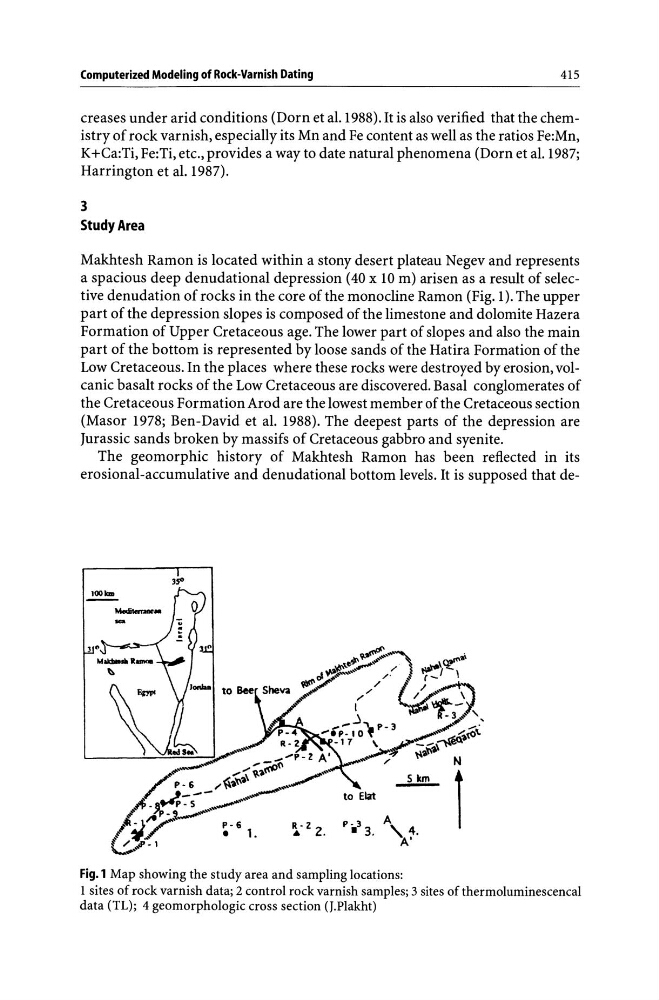
a spacious deep denudational depression (40 x 10 m) arisen as a result of selective denudation of rocks in the core of the monocline Ramon (Fig. 1). The upper
part of the depression slopes is composed of the limestone and dolomite Hazera
Formation of Upper Cretaceous age. The lower part of slopes and also the main
part of the bottom is represented by loose sands of the Hatira Formation of the
Low Cretaceous. In the places where these rocks were destroyed by erosion, volcanic basalt rocks of the Low Cretaceous are discovered. Basal conglomerates of
the Cretaceous Formation Arod are the lowest member of the Cretaceous section
(Mas or 1978; Ben-David et al. 1988). The deepest parts of the depression are
Jurassic sands broken by massifs of Cretaceous gabbro and syenite.
The geomorphic history of Makhtesh Ramon has been reflected in its
erosional-accumulative and denudational bottom levels. It is supposed that deFig.l Map showing the study area and sampling locations:
1 sites of rock varnish data; 2 control rock varnish samples; 3 sites of thermoluminescencal
data (TL); 4 geomorphologic cross section (J.Plakht)
415
creases under arid conditions (Dorn et al.I988).1t is also verified that the chemistry of rock varnish, especially its Mn and Fe content as well as the ratios Fe:Mn,
K +Ca:Ti, Fe:Ti, etc., provides a way to date natural phenomena (Dorn et al. 1987;
Harrington et al. 1987).
3
Study Area
Makhtesh Ramon is located within a stony desert plateau Negev and represents
a spacious deep denudational depression (40 x 10 m) arisen as a result of selective denudation of rocks in the core of the monocline Ramon (Fig. 1). The upper
part of the depression slopes is composed of the limestone and dolomite Hazera
Formation of Upper Cretaceous age. The lower part of slopes and also the main
part of the bottom is represented by loose sands of the Hatira Formation of the
Low Cretaceous. In the places where these rocks were destroyed by erosion, volcanic basalt rocks of the Low Cretaceous are discovered. Basal conglomerates of
the Cretaceous Formation Arod are the lowest member of the Cretaceous section
(Mas or 1978; Ben-David et al. 1988). The deepest parts of the depression are
Jurassic sands broken by massifs of Cretaceous gabbro and syenite.
The geomorphic history of Makhtesh Ramon has been reflected in its
erosional-accumulative and denudational bottom levels. It is supposed that deFig.l Map showing the study area and sampling locations:
1 sites of rock varnish data; 2 control rock varnish samples; 3 sites of thermoluminescencal
data (TL); 4 geomorphologic cross section (J.Plakht)