

366
C. Hoselmann . H. Streif
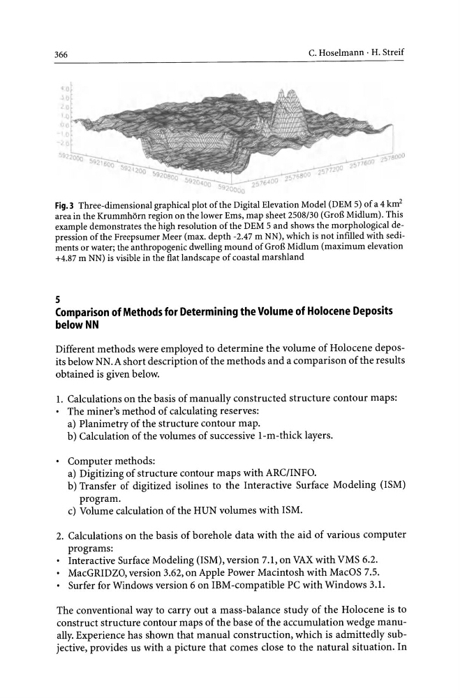
Fig.3 Three-dimensional graphical plot of the Digital Elevation Model (DEM 5) of a 4 km 2
area in the KrummhOrn region on the lower Ems, map sheet 2508/30 (GroB Midlum). This
example demonstrates the high resolution of the DEM 5 and shows the morphological depression of the Freepsumer Meer (max. depth -2.47 m NN), which is not infilled with sediments or water; the anthropogenic dwelling mound of GroB Midlum (maximum elevation
+4.87 m NN) is visible in the flat landscape of coastal marshland
5
Comparison of Methods for Determining the Volume of Holocene Deposits
belowNN
Different methods were employed to determine the volume of Holocene deposits below NN.A short description of the methods and a comparison of the results
obtained is given below.
1. Calculations on the basis of manually constructed structure contour maps:
• The miner's method of calculating reserves:
a) Planimetry of the structure contour map.
b) Calculation of the volumes of successive 1-m -thick layers.
• Computer methods:
a) Digitizing of structure contour maps with ARC/INFO.
b) Transfer of digitized isolines to the Interactive Surface Modeling (ISM)
program.
c) Volume calculation of the HUN volumes with ISM.
2. Calculations on the basis of borehole data with the aid of various computer
programs:
• Interactive Surface Modeling (ISM), version 7.1, on VAX with VMS 6.2.
• MacGRIDZO, version 3.62, on Apple Power Macintosh with MacOS 7.5.
• Surfer for Windows version 6 on IBM-compatible PC with Windows 3.1.
The conventional way to carry out a mass-balance study of the Holocene is to
construct structure contour maps of the base of the accumulation wedge manually. Experience has shown that manual construction, which is admittedly subjective, provides us with a picture that comes close to the natural situation. In
C. Hoselmann . H. Streif
Fig.3 Three-dimensional graphical plot of the Digital Elevation Model (DEM 5) of a 4 km 2
area in the KrummhOrn region on the lower Ems, map sheet 2508/30 (GroB Midlum). This
example demonstrates the high resolution of the DEM 5 and shows the morphological depression of the Freepsumer Meer (max. depth -2.47 m NN), which is not infilled with sediments or water; the anthropogenic dwelling mound of GroB Midlum (maximum elevation
+4.87 m NN) is visible in the flat landscape of coastal marshland
5
Comparison of Methods for Determining the Volume of Holocene Deposits
belowNN
Different methods were employed to determine the volume of Holocene deposits below NN.A short description of the methods and a comparison of the results
obtained is given below.
1. Calculations on the basis of manually constructed structure contour maps:
• The miner's method of calculating reserves:
a) Planimetry of the structure contour map.
b) Calculation of the volumes of successive 1-m -thick layers.
• Computer methods:
a) Digitizing of structure contour maps with ARC/INFO.
b) Transfer of digitized isolines to the Interactive Surface Modeling (ISM)
program.
c) Volume calculation of the HUN volumes with ISM.
2. Calculations on the basis of borehole data with the aid of various computer
programs:
• Interactive Surface Modeling (ISM), version 7.1, on VAX with VMS 6.2.
• MacGRIDZO, version 3.62, on Apple Power Macintosh with MacOS 7.5.
• Surfer for Windows version 6 on IBM-compatible PC with Windows 3.1.
The conventional way to carry out a mass-balance study of the Holocene is to
construct structure contour maps of the base of the accumulation wedge manually. Experience has shown that manual construction, which is admittedly subjective, provides us with a picture that comes close to the natural situation. In