

344
W. L. Watney . J. Kruger· J. c. Davis· J. Harff . R. A. Olea, . G. C. Bohling
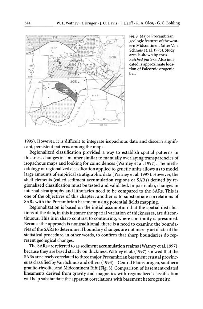
Fig.3 Major Precambrian
geologic features of the western Midcontinent (after Van
Schmus et. al. 1993). Study
area is shown by crosshatched pattern. Also indicated is approximate location of Paleozoic orogenic
belt
1995). However, it is difficult to integrate isopachous data and discern significant, persistent patterns among the maps.
Regionalized classification provided a way to establish spatial patterns in
thickness changes in a manner similar to manually overlaying transparencies of
isopachous maps and looking for coincidences (Watney et al. 1997). The methodology of regionalized classification applied to genetic units allows us to model
large amounts of empirical stratigraphic data (Watney et al. 1997). However, the
shelf elements (called sediment accumulation regions or SARs) defined by regionalized classification must be tested and validated. In particular, changes in
internal stratigraphy and lithofacies need to be compared to the SARs. This is
one of the objectives of this chapter; another is to substantiate correlations of
SARs with the Precambrian basement using potential fields mapping.
Regionalization is based on the initial assumption that the spatial distributions of the data, in this instance the spatial variation of thicknesses, are discontinuous. This is in sharp contrast to contouring, where continuity is presumed.
Because the approach is nontraditional, there is a need to examine the boundaries of the SARs to determine if boundary changes are not merely artifacts of the
statistical procedure, in other words, to confirm that sharp boundaries do represent geological changes.
The SARs are referred to as sediment accumulation realms (Watney et al. 1997),
because they are based strictly on thickness. Watney et al. (1997) showed that the
SARs are closely correlated to three major Precambrian basement crustal provinces as classified by Van Schmus and others (1993) - Central Plains orogen,southern
granite-rhyolite, and Midcontinent Rift (Fig. 3). Comparison of basement -related
lineaments derived from gravity and magnetics with regionalized classification
will help substantiate the apparent correlations with basement heterogeneity.
W. L. Watney . J. Kruger· J. c. Davis· J. Harff . R. A. Olea, . G. C. Bohling
Fig.3 Major Precambrian
geologic features of the western Midcontinent (after Van
Schmus et. al. 1993). Study
area is shown by crosshatched pattern. Also indicated is approximate location of Paleozoic orogenic
belt
1995). However, it is difficult to integrate isopachous data and discern significant, persistent patterns among the maps.
Regionalized classification provided a way to establish spatial patterns in
thickness changes in a manner similar to manually overlaying transparencies of
isopachous maps and looking for coincidences (Watney et al. 1997). The methodology of regionalized classification applied to genetic units allows us to model
large amounts of empirical stratigraphic data (Watney et al. 1997). However, the
shelf elements (called sediment accumulation regions or SARs) defined by regionalized classification must be tested and validated. In particular, changes in
internal stratigraphy and lithofacies need to be compared to the SARs. This is
one of the objectives of this chapter; another is to substantiate correlations of
SARs with the Precambrian basement using potential fields mapping.
Regionalization is based on the initial assumption that the spatial distributions of the data, in this instance the spatial variation of thicknesses, are discontinuous. This is in sharp contrast to contouring, where continuity is presumed.
Because the approach is nontraditional, there is a need to examine the boundaries of the SARs to determine if boundary changes are not merely artifacts of the
statistical procedure, in other words, to confirm that sharp boundaries do represent geological changes.
The SARs are referred to as sediment accumulation realms (Watney et al. 1997),
because they are based strictly on thickness. Watney et al. (1997) showed that the
SARs are closely correlated to three major Precambrian basement crustal provinces as classified by Van Schmus and others (1993) - Central Plains orogen,southern
granite-rhyolite, and Midcontinent Rift (Fig. 3). Comparison of basement -related
lineaments derived from gravity and magnetics with regionalized classification
will help substantiate the apparent correlations with basement heterogeneity.