

6
K. Black· M. Green· T. Healy· R. Bell· J. Oldman· T. Hume
and masses carried by all particles within layers, and dividing by the layer volume V (=200 x 200 x 0.05 m 3 ); a layer thickness of 0.05 m provided sufficient resolution for the present study. Examples of the vertical particle distribution from
POL3DD over bedforms are presented by Black et al. (1997).
3
Field Measurements
The field site lies in the eastern sector of the Manukau Harbour, which is a large
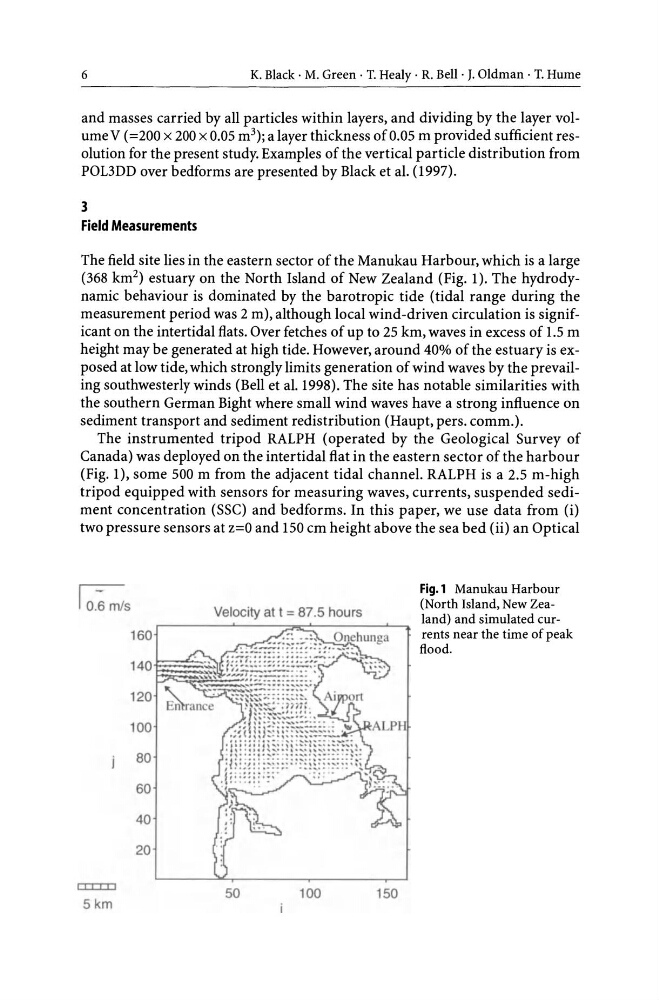
(368 km 2 ) estuary on the North Island of New Zealand (Fig. l). The hydrodynamic behaviour is dominated by the barotropic tide (tidal range during the
measurement period was 2 m), although local wind-driven circulation is significant on the intertidal flats. Over fetches of up to 25 km, waves in excess of 1.5 m
height may be generated at high tide. However, around 40% of the estuary is exposed at low tide, which strongly limits generation of wind waves by the prevailing southwesterly winds (Bell et al.I998). The site has notable similarities with
the southern German Bight where small wind waves have a strong influence on
sediment transport and sediment redistribution (Haupt, pers. comm.).
The instrumented tripod RALPH (operated by the Geological Survey of
Canada) was deployed on the intertidal flat in the eastern sector of the harbour
(Fig. l), some 500 m from the adjacent tidal channel. RALPH is a 2.5 m-high
tripod equipped with sensors for measuring waves, currents, suspended sediment concentration (SSC) and bedforms. In this paper, we use data from (i)
two pressure sensors at Z=O and 150 cm height above the sea bed (ii) an Optical
I O. ~ mls
~
5km
Velocity at t = 87.5 hours
50
100
150
Fig.l Manukau Harbour
(North Island, New Zealand) and simulated currents near the time of peak
flood.
K. Black· M. Green· T. Healy· R. Bell· J. Oldman· T. Hume
and masses carried by all particles within layers, and dividing by the layer volume V (=200 x 200 x 0.05 m 3 ); a layer thickness of 0.05 m provided sufficient resolution for the present study. Examples of the vertical particle distribution from
POL3DD over bedforms are presented by Black et al. (1997).
3
Field Measurements
The field site lies in the eastern sector of the Manukau Harbour, which is a large
(368 km 2 ) estuary on the North Island of New Zealand (Fig. l). The hydrodynamic behaviour is dominated by the barotropic tide (tidal range during the
measurement period was 2 m), although local wind-driven circulation is significant on the intertidal flats. Over fetches of up to 25 km, waves in excess of 1.5 m
height may be generated at high tide. However, around 40% of the estuary is exposed at low tide, which strongly limits generation of wind waves by the prevailing southwesterly winds (Bell et al.I998). The site has notable similarities with
the southern German Bight where small wind waves have a strong influence on
sediment transport and sediment redistribution (Haupt, pers. comm.).
The instrumented tripod RALPH (operated by the Geological Survey of
Canada) was deployed on the intertidal flat in the eastern sector of the harbour
(Fig. l), some 500 m from the adjacent tidal channel. RALPH is a 2.5 m-high
tripod equipped with sensors for measuring waves, currents, suspended sediment concentration (SSC) and bedforms. In this paper, we use data from (i)
two pressure sensors at Z=O and 150 cm height above the sea bed (ii) an Optical
I O. ~ mls
~
5km
Velocity at t = 87.5 hours
50
100
150
Fig.l Manukau Harbour
(North Island, New Zealand) and simulated currents near the time of peak
flood.