

154
C. N. Wold· G. J. Schwartz· C. Morrill
E
...
raIl>
.'i:
II>
~
0 a. ra
>
w
E ...
' "
e!
«
"C
c
j
ra
e!
«
"0
C
ra
...J
E II>
~
CI>
a.
50000
a.
40000
30000
20000
10000
0
-60
·40
-20
o
20
40
60
2e+06
b.
1.5e+06
l e+06
500000
0 I
-60
·40
-20
o
20
40
60
3.0 -r-- ........ ---L--'----'---'----'-----'--.l......--'--y--'----I.--+
I/)
~
0 a. ra >
W
>.c
"C
e! .. > 0
u
c.
2.5 -
I
2.0
------------------------1-------------1.5
1.0
0.5
-60
-40
s
,
,
I
-------,-----20
o
latitude
20
40
60
N
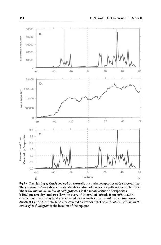
Fig.3a Total land area (km 2 ) covered by naturally occurring evaporites at the present time.
The gray-shaded area shows the standard deviation of evaporites with respect to latitude.
The white line in the middle of each gray area is the mean latitude of evaporites.
b Total present -day land area (km 2 ) in every 1 ° interval of latitude from 60 0 S to 60 0 N.
c Percent of present -day land area covered by evaporites. Horizontal dashed lines were
drawn at 1 and 2% of total land area covered by evaporites. The vertical-dashed line in the
center of each diagram is the location of the equator
C. N. Wold· G. J. Schwartz· C. Morrill
E
...
raIl>
.'i:
II>
~
0 a. ra
>
w
E ...
' "
e!
«
"C
c
j
ra
e!
«
"0
C
ra
...J
E II>
~
CI>
a.
50000
a.
40000
30000
20000
10000
0
-60
·40
-20
o
20
40
60
2e+06
b.
1.5e+06
l e+06
500000
0 I
-60
·40
-20
o
20
40
60
3.0 -r-- ........ ---L--'----'---'----'-----'--.l......--'--y--'----I.--+
I/)
~
0 a. ra >
W
>.c
"C
e! .. > 0
u
c.
2.5 -
I
2.0
------------------------1-------------1.5
1.0
0.5
-60
-40
s
,
,
I
-------,-----20
o
latitude
20
40
60
N
Fig.3a Total land area (km 2 ) covered by naturally occurring evaporites at the present time.
The gray-shaded area shows the standard deviation of evaporites with respect to latitude.
The white line in the middle of each gray area is the mean latitude of evaporites.
b Total present -day land area (km 2 ) in every 1 ° interval of latitude from 60 0 S to 60 0 N.
c Percent of present -day land area covered by evaporites. Horizontal dashed lines were
drawn at 1 and 2% of total land area covered by evaporites. The vertical-dashed line in the
center of each diagram is the location of the equator