

586
a
b
Chapter 12 Basin Evolution and Sediments
CASCADIA
ACCRETIONARY WEDGE
SEA LEVEL
c
DEfORMATION
FRO'IT
TOFINO
BASIN
CQAST
VANCOUVER
GEORGIA
STRAIT
COAST
RANGE
E
:.
J:
Ia..
w
o
km
d
km
DEfORMATION
FRO'IT
-<>
3"
UNE
ISLAND
OLYMPIC
MOUNTAINS
e BARBADOS RIDGE
DEFORMATION FRONT
BARBADOS RIDGE COMPLEX
\
OCEANIC PLATE
5 4 ; - r -
STEEPE .... '" CF
i FORWARD AND UPWARD
E
._""
EARLV PACKAGE
F'RQPAGA TlNG
ACTIVE LATE THRUSTS
w
1:ARLV THRUSTS
BOUNOING
I THRUSTS
67 54 1
INQIPIENT
4
5
6
km
BELOW SEA
LEVEL
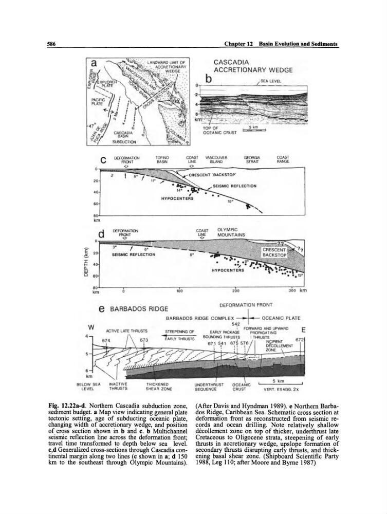
Fig. 12.22a-d. Northern Cascadia subduction zone,
sediment budget. a Map view indicating general plate
tectonic setting, age of subducting oceanic plate,
changing width of accretionary wedge, and position
of cross section shown in band e. b Multichannel
seismic reflection line across the deformation front;
travel time transformed to depth below sea level.
e,d Generalized cross-sections through Cascadia continental margin along two lines (e shown in a; d 150
km to the southeast through Olympic Mountains).
I
~COlLEMENT
•
ZONE
CRUST
VERT . E)(AGG. 2x
(After Davis and Hyndman 1989). e Northern Barbados Ridge, Caribbean Sea. Schematic cross section at
deformation front as reconstructed from seismic records and ocean drilling. Note relatively shallow
decollement zone on top of thicker, underthrust late
Cretaceous to Oligocene strata, steepening of early
thrusts in accretionary wedge, upslope formation of
secondary thrusts disrupting early thrusts, and thickening basal shear zone. (Shipboard Scientific Party
1988, Leg 110; after Moore and Byrne 1987)