

524
Chapter 11 Sediment Supply, Subsidence, and Basin Fill
~ BENUE
a
r
Niger Delta
(Present)
;. TROUGIl. (I
Tripie
-...
~):'
Junction ;, ..•.... '. " '- . •
E. CRET.
- - ... "..... Oligoc .
---"
- -
"
I· · • .
50 km
Continental sands
NNE
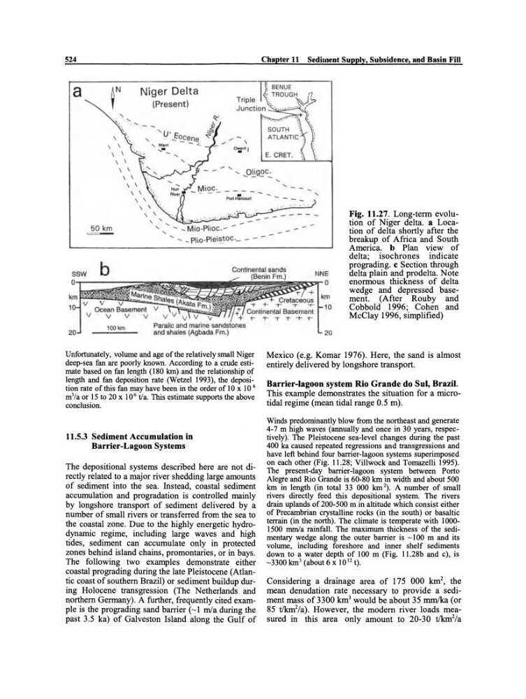
Fig. 11.27. Long-term evolution of Niger delta. a Location of delta shortly after the
breakup of Africa and South
America. b Plan view of
delta; isochrones indicate
prograding. c Section through
delta plain and prodelta. Note
enormous thickness of delta
wedge and depressed basement. (After Rouby and
Cobbold 1996; Cohen imd
McClay 1996, simplified)
~~=,-o
v
Cretaceous km
-t- + -t- -r -.-- 10
Continental Basement
r-t-TT--r-t100 km
Paralic and marine
and shales (Agbada Fm.)
Unfortunately, volume and age ofthe relatively small Niger
deep-sea fan are poorly known. Aeeording to a erude estimate based on fan length (180 km) and the relationship of
length and fan deposition rate (Wetzel 1993), the deposition rate ofthis fan may have been in the order of 10 x 10 6
m 3 /a or 15 to 20 x 10 6 tla. This estimate supports the above
eonclusion.
11.5.3 Sediment Accumulation in
Barrier-Lagoon Systems
The depositional systems described here are not directly related to a major river shedding large amounts
of sediment into the sea. Instead, coastal sediment
accumulation and pro gradation is controlled rnainly
by longshore transport of sediment delivered by a
number of small rivers or transferred from the sea to
the coastal zone. Due to the highly energetic hydrodynamic regime, including large waves and high
tides, sediment can accumulate only in protected
zones behind island chains, promontaries, or in bays.
The following two examples demonstrate either
coastal prograding during the late Pleistocene (Atlantic coast of southem Brazil) or sediment buildup during Holocene transgression (The Netherlands and
northem Germany). A further, frequently cited exampIe is the prograding sand barrier (~1 mla during the
past 3.5 ka) of Galveston Island along the Gulf of
20
Mexico (e.g. Komar 1976). Here, the sand is almost
entirely delivered by longshore transport.
Barrier-Iagoon system Rio Grande do Sul, Brazil.
This example demonstrates the situation for a microtidal regime (mean tidal range 0.5 m).
Winds predominantly blow trom the northeast and generate
4-7 m high waves (annually and onee in 30 years, respeetively). The Pleistoeene sea-level ehanges during the past
400 ka eaused repeated regressions and transgressions and
have left behind four barrier-lagoon systems superimposed
on eaeh other (Fig. 11.28; Villwoek and Tomazelli 1995).
The present-day barrier-lagoon system between Porto
Alegre and Rio Grande is 60-80 km in width and about 500
km in length (in total 33 000 km 2). A number of small
rivers direetly feed this depositional system. The rivers
drain uplands of 200-500 m in altitude whieh eonsist either
of Preeambrian erystalline rocks (in the south) or basaltie
terrain (in the north). The climate is temperate with 10001500 mmla rainfall. The maximum thiekness of the sedimentary wedge along the outer barrier is ~ 100 m and its
volume, including foreshore and inner shelf sediments
down to a water depth of 100 m (Fig. 11.28b and e), is
-3300 km 3 (about 6 x 10 12 t).
Considering a drainage area of 175 000 km2, the
mean denudation rate necessary to provide a sediment rnass of3300 km 3 would be about 35 mm/ka (or
85 t!km 2 /a). However, the modem river loads measured in this area only amount to 20-30 tlkm 2 /a
Chapter 11 Sediment Supply, Subsidence, and Basin Fill
~ BENUE
a
r
Niger Delta
(Present)
;. TROUGIl. (I
Tripie
-...
~):'
Junction ;, ..•.... '. " '- . •
E. CRET.
- - ... "..... Oligoc .
---"
- -
"
I· · • .
50 km
Continental sands
NNE
Fig. 11.27. Long-term evolution of Niger delta. a Location of delta shortly after the
breakup of Africa and South
America. b Plan view of
delta; isochrones indicate
prograding. c Section through
delta plain and prodelta. Note
enormous thickness of delta
wedge and depressed basement. (After Rouby and
Cobbold 1996; Cohen imd
McClay 1996, simplified)
~~=,-o
v
Cretaceous km
-t- + -t- -r -.-- 10
Continental Basement
r-t-TT--r-t100 km
Paralic and marine
and shales (Agbada Fm.)
Unfortunately, volume and age ofthe relatively small Niger
deep-sea fan are poorly known. Aeeording to a erude estimate based on fan length (180 km) and the relationship of
length and fan deposition rate (Wetzel 1993), the deposition rate ofthis fan may have been in the order of 10 x 10 6
m 3 /a or 15 to 20 x 10 6 tla. This estimate supports the above
eonclusion.
11.5.3 Sediment Accumulation in
Barrier-Lagoon Systems
The depositional systems described here are not directly related to a major river shedding large amounts
of sediment into the sea. Instead, coastal sediment
accumulation and pro gradation is controlled rnainly
by longshore transport of sediment delivered by a
number of small rivers or transferred from the sea to
the coastal zone. Due to the highly energetic hydrodynamic regime, including large waves and high
tides, sediment can accumulate only in protected
zones behind island chains, promontaries, or in bays.
The following two examples demonstrate either
coastal prograding during the late Pleistocene (Atlantic coast of southem Brazil) or sediment buildup during Holocene transgression (The Netherlands and
northem Germany). A further, frequently cited exampIe is the prograding sand barrier (~1 mla during the
past 3.5 ka) of Galveston Island along the Gulf of
20
Mexico (e.g. Komar 1976). Here, the sand is almost
entirely delivered by longshore transport.
Barrier-Iagoon system Rio Grande do Sul, Brazil.
This example demonstrates the situation for a microtidal regime (mean tidal range 0.5 m).
Winds predominantly blow trom the northeast and generate
4-7 m high waves (annually and onee in 30 years, respeetively). The Pleistoeene sea-level ehanges during the past
400 ka eaused repeated regressions and transgressions and
have left behind four barrier-lagoon systems superimposed
on eaeh other (Fig. 11.28; Villwoek and Tomazelli 1995).
The present-day barrier-lagoon system between Porto
Alegre and Rio Grande is 60-80 km in width and about 500
km in length (in total 33 000 km 2). A number of small
rivers direetly feed this depositional system. The rivers
drain uplands of 200-500 m in altitude whieh eonsist either
of Preeambrian erystalline rocks (in the south) or basaltie
terrain (in the north). The climate is temperate with 10001500 mmla rainfall. The maximum thiekness of the sedimentary wedge along the outer barrier is ~ 100 m and its
volume, including foreshore and inner shelf sediments
down to a water depth of 100 m (Fig. 11.28b and e), is
-3300 km 3 (about 6 x 10 12 t).
Considering a drainage area of 175 000 km2, the
mean denudation rate necessary to provide a sediment rnass of3300 km 3 would be about 35 mm/ka (or
85 t!km 2 /a). However, the modem river loads measured in this area only amount to 20-30 tlkm 2 /a