

9.2 Chemical Denudation
433
CHEMICAL DENUDATION RATES IN DIFFERENT MORPHO-CLIMATIC ZONES
TUNDRA
AND
TAIGA
TAIGA
TEMPERATE
400
200
20
40
HUMID
VERY VERY
HUMID
MID
CONCENTRA TlON
OF TOS
TRANSPORT RATE
80
OF TOS 1)
t /km 2 /a
40
10
20
30
CHEMICAL
DENUDATION
RATE (DReH)
mm/ka or m/Ma
2)
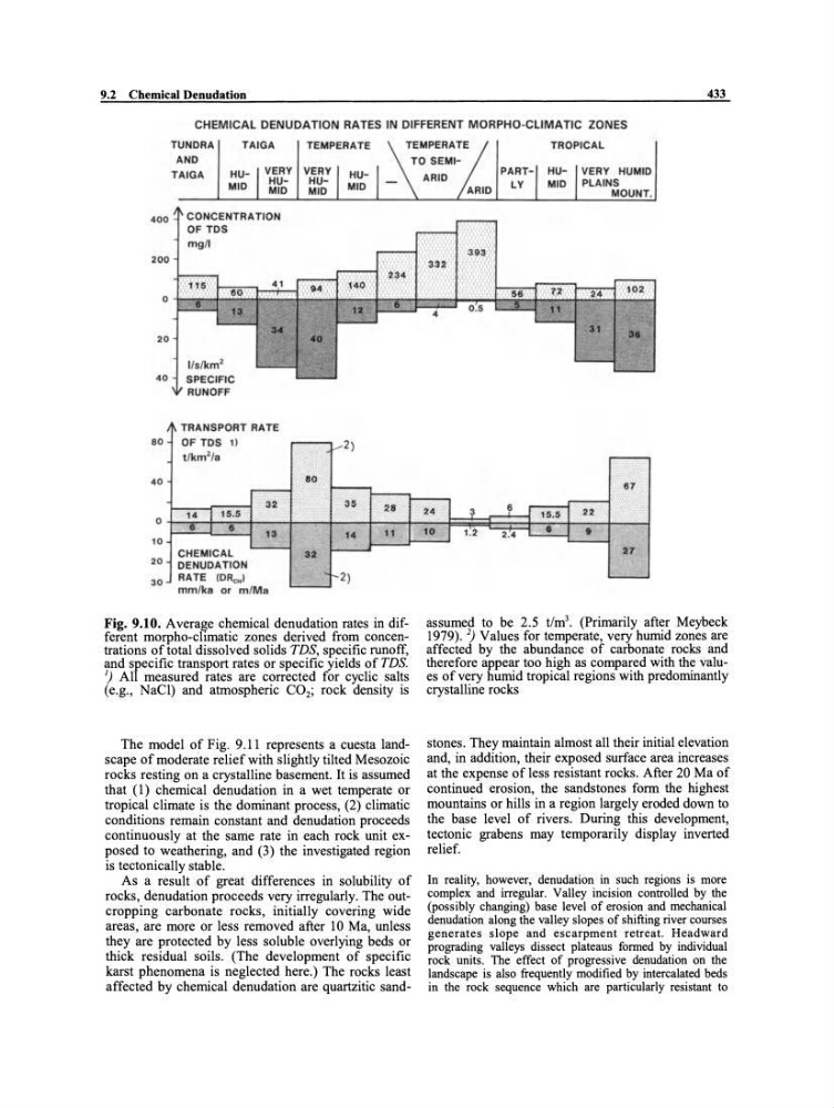
Fig. 9.10. Average chemical denudation rates in different morpho-clirnatic zones derived from concentrations of total dissolved so lids TDS, specific runoff,
and srecific transport rates or specific yields of TDS.
1) Al measured rates are corrected for cyclic salts
(e.g., NaCI) and atmospheric CO 2 ; rock density is
The model of Fig. 9.11 represents a cuesta landscape of moderate relief with slightly tilted Mesozoic
rocks resting on a crystalline basement. It is assumed
that (1) chemical denudation in a wet temperate or
tropical climate is the dominant process, (2) climatic
conditions remain constant and denudation proceeds
continuously at the same rate in each rock unit exposed to weathering, and (3) the investigated region
is tectonically stable.
As a result of great differences in solubility of
rocks, denudation proceeds very irregularly. The outcropping carbonate rocks, initially covering wide
areas, are more or less removed after 10 Ma, unless
they are protected by less soluble overlying beds or
thick residual soils. (The development of specific
karst phenomena is neglected here.) The rocks least
affected by chemical denudation are quartzitic sandTROPICAL
VERY HUMID
PLAINS
MOUNT.
27
assumed to be 2.5 t/m 3 • (Prirnarily after Meybeck
1979).2) Values for temperate, very humid zones are
affected by the abundance of carbonate rocks and
therefore appear too high as compared with the values of very humid tropical regions with predominantly
crystalline rocks
stones. They maintain almost all their initial elevation
and, in addition, their exposed surface area increases
at the expense of less resistant rocks. After 20 Ma of
continued erosion, the sandstones form the highest
mountains or hills in a region largely eroded down to
the base level of rivers. During this development,
tectonic grabens may temporarily display inverted
relief.
In reality, however, denudation in such regions is more
complex and irregular. Valley incision controlled by the
(possibly changing) base level of erosion and mechanical
denudation along the valley slopes of shifting river courses
generates slope and escarpment retreat. Headward
prograding valleys dissect plateaus formed by individual
rock units. The effect of progressive denudation on the
landscape is also frequently modified by intercalated beds
in the rock sequence which are particularly resistant to
433
CHEMICAL DENUDATION RATES IN DIFFERENT MORPHO-CLIMATIC ZONES
TUNDRA
AND
TAIGA
TAIGA
TEMPERATE
400
200
20
40
HUMID
VERY VERY
HUMID
MID
CONCENTRA TlON
OF TOS
TRANSPORT RATE
80
OF TOS 1)
t /km 2 /a
40
10
20
30
CHEMICAL
DENUDATION
RATE (DReH)
mm/ka or m/Ma
2)
Fig. 9.10. Average chemical denudation rates in different morpho-clirnatic zones derived from concentrations of total dissolved so lids TDS, specific runoff,
and srecific transport rates or specific yields of TDS.
1) Al measured rates are corrected for cyclic salts
(e.g., NaCI) and atmospheric CO 2 ; rock density is
The model of Fig. 9.11 represents a cuesta landscape of moderate relief with slightly tilted Mesozoic
rocks resting on a crystalline basement. It is assumed
that (1) chemical denudation in a wet temperate or
tropical climate is the dominant process, (2) climatic
conditions remain constant and denudation proceeds
continuously at the same rate in each rock unit exposed to weathering, and (3) the investigated region
is tectonically stable.
As a result of great differences in solubility of
rocks, denudation proceeds very irregularly. The outcropping carbonate rocks, initially covering wide
areas, are more or less removed after 10 Ma, unless
they are protected by less soluble overlying beds or
thick residual soils. (The development of specific
karst phenomena is neglected here.) The rocks least
affected by chemical denudation are quartzitic sandTROPICAL
VERY HUMID
PLAINS
MOUNT.
27
assumed to be 2.5 t/m 3 • (Prirnarily after Meybeck
1979).2) Values for temperate, very humid zones are
affected by the abundance of carbonate rocks and
therefore appear too high as compared with the values of very humid tropical regions with predominantly
crystalline rocks
stones. They maintain almost all their initial elevation
and, in addition, their exposed surface area increases
at the expense of less resistant rocks. After 20 Ma of
continued erosion, the sandstones form the highest
mountains or hills in a region largely eroded down to
the base level of rivers. During this development,
tectonic grabens may temporarily display inverted
relief.
In reality, however, denudation in such regions is more
complex and irregular. Valley incision controlled by the
(possibly changing) base level of erosion and mechanical
denudation along the valley slopes of shifting river courses
generates slope and escarpment retreat. Headward
prograding valleys dissect plateaus formed by individual
rock units. The effect of progressive denudation on the
landscape is also frequently modified by intercalated beds
in the rock sequence which are particularly resistant to