

132
A.C. Smaal . A. van der Hoek
the south-west Netherlands is one of ongoing struggle between people and the sea.
People have been reclaiming the saltmarshes in this area and converting them into
farmland since 1000 A.D. However, at various times the sea walls have been breached
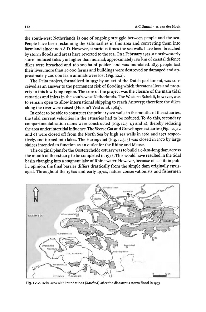
by storm floods and areas have reverted to the sea. On 1 February 1953, a northwesterly
storm induced tides 3 m higher than normal; approximately 180 km of coastal defence
dikes were breached and 160 000 ha of polder land was inundated. 1835 people lost
their lives, more than 46 000 farms and buildings were destroyed or damaged and approximately 200 000 farm animals were lost (Fig. 12.2).
The Delta project, formalized in 1957 by an act of the Dutch parliament, was conceived as an answer to the permanent risk of flooding which threatens lives and property in this low-lying region. The core of the project was the closure of the main tidal
estuaries and inlets in the south-west Netherlands. The Western ScheIdt, however, was
to remain open to allow international shipping to reach Antwerp; therefore the dikes
along the river were raised (Huis in't Veld et ai. 1984).
In order to be able to construct the primary sea walls in the mouths of the estuaries,
the tidal current velocities in the estuaries had to be reduced. To do this, secondary
compartmentalization dams were constructed (Fig. 12.3: 1,3 and 4), thereby reducing
the area under intertidal influence. The Veerse Gat and Grevelingen estuaries (Fig. 12.3: 2
and 6) were closed off from the North Sea by high sea walls in 1961 and 1971 respectively, and turned into lakes. The Haringvliet (Fig. 12.3: 5) was closed in 1970 by large
sluices intended to function as an outlet for the Rhine and Meuse.
The original plan for the Oosterschelde estuary was to build a 9-km-long dam across
the mouth of the estuary, to be completed in 1978. This would have resulted in the tidal
basin changing into a stagnant lake of Rhine water. However, because of a shift in public opinion, the final barrier differs drastically from the simple dam originally envisaged. Throughout the 1960s and early 1970S, nature conservationists and fishermen
Fig. 12.2. Delta area with inundations (hatched) after the disastrous storm flood in 1953
A.C. Smaal . A. van der Hoek
the south-west Netherlands is one of ongoing struggle between people and the sea.
People have been reclaiming the saltmarshes in this area and converting them into
farmland since 1000 A.D. However, at various times the sea walls have been breached
by storm floods and areas have reverted to the sea. On 1 February 1953, a northwesterly
storm induced tides 3 m higher than normal; approximately 180 km of coastal defence
dikes were breached and 160 000 ha of polder land was inundated. 1835 people lost
their lives, more than 46 000 farms and buildings were destroyed or damaged and approximately 200 000 farm animals were lost (Fig. 12.2).
The Delta project, formalized in 1957 by an act of the Dutch parliament, was conceived as an answer to the permanent risk of flooding which threatens lives and property in this low-lying region. The core of the project was the closure of the main tidal
estuaries and inlets in the south-west Netherlands. The Western ScheIdt, however, was
to remain open to allow international shipping to reach Antwerp; therefore the dikes
along the river were raised (Huis in't Veld et ai. 1984).
In order to be able to construct the primary sea walls in the mouths of the estuaries,
the tidal current velocities in the estuaries had to be reduced. To do this, secondary
compartmentalization dams were constructed (Fig. 12.3: 1,3 and 4), thereby reducing
the area under intertidal influence. The Veerse Gat and Grevelingen estuaries (Fig. 12.3: 2
and 6) were closed off from the North Sea by high sea walls in 1961 and 1971 respectively, and turned into lakes. The Haringvliet (Fig. 12.3: 5) was closed in 1970 by large
sluices intended to function as an outlet for the Rhine and Meuse.
The original plan for the Oosterschelde estuary was to build a 9-km-long dam across
the mouth of the estuary, to be completed in 1978. This would have resulted in the tidal
basin changing into a stagnant lake of Rhine water. However, because of a shift in public opinion, the final barrier differs drastically from the simple dam originally envisaged. Throughout the 1960s and early 1970S, nature conservationists and fishermen
Fig. 12.2. Delta area with inundations (hatched) after the disastrous storm flood in 1953