

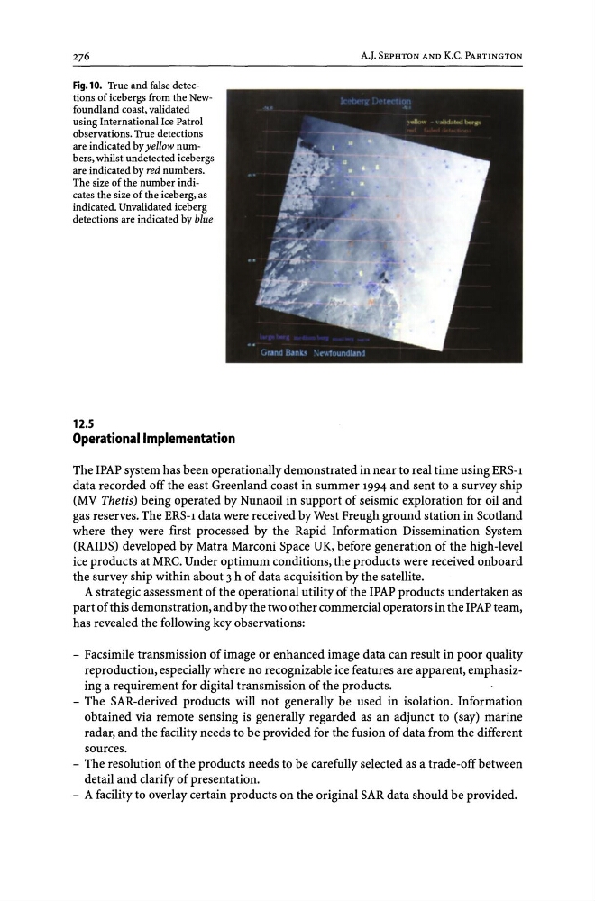
Fig.10. True and false detections of icebergs from the Newfoundland coast, validated
using International Ice Patrol
observations. True detections
are indicated by yellow numbers, whilst undetected icebergs
are indicated by red numbers.
The size of the number indicates the size of the iceberg, as
indicated. Unvalidated iceberg
detections are indicated by blue
12.5
Operational Implementation
A.J. SEPHTON AND K.C. PARTINGTON
The IPAP system has been operationally demonstrated in near to real time using ERS-1
data recorded off the east Greenland coast in summer 1994 and sent to a survey ship
(MV Thetis) being operated by Nunaoil in support of seismic exploration for oil and
gas reserves. The ERS-1 data were received by West Freugh ground station in Scotland
where they were first processed by the Rapid Information Dissemination System
(RAIDS) developed by Matra Marconi Space UK, before generation of the high-level
ice products at MRC. Under optimum conditions, the products were received onboard
the survey ship within about 3 h of data acquisition by the satellite.
A strategic assessment of the operational utility of the IPAP products undertaken as
part of this demonstration, and by the two other commercial operators in the IPAP team,
has revealed the following key observations:
- Facsimile transmission of image or enhanced image data can result in poor quality
reproduction, especially where no recognizable ice features are apparent, emphasizing a requirement for digital transmission of the products.
- The SAR-derived products will not generally be used in isolation. Information
obtained via remote sensing is generally regarded as an adjunct to (say) marine
radar, and the facility needs to be provided for the fusion of data from the different
sources.
- The resolution of the products needs to be carefully selected as a trade-off between
detail and clarify of presentation.
- A facility to overlay certain products on the original SAR data should be provided.
using International Ice Patrol
observations. True detections
are indicated by yellow numbers, whilst undetected icebergs
are indicated by red numbers.
The size of the number indicates the size of the iceberg, as
indicated. Unvalidated iceberg
detections are indicated by blue
12.5
Operational Implementation
A.J. SEPHTON AND K.C. PARTINGTON
The IPAP system has been operationally demonstrated in near to real time using ERS-1
data recorded off the east Greenland coast in summer 1994 and sent to a survey ship
(MV Thetis) being operated by Nunaoil in support of seismic exploration for oil and
gas reserves. The ERS-1 data were received by West Freugh ground station in Scotland
where they were first processed by the Rapid Information Dissemination System
(RAIDS) developed by Matra Marconi Space UK, before generation of the high-level
ice products at MRC. Under optimum conditions, the products were received onboard
the survey ship within about 3 h of data acquisition by the satellite.
A strategic assessment of the operational utility of the IPAP products undertaken as
part of this demonstration, and by the two other commercial operators in the IPAP team,
has revealed the following key observations:
- Facsimile transmission of image or enhanced image data can result in poor quality
reproduction, especially where no recognizable ice features are apparent, emphasizing a requirement for digital transmission of the products.
- The SAR-derived products will not generally be used in isolation. Information
obtained via remote sensing is generally regarded as an adjunct to (say) marine
radar, and the facility needs to be provided for the fusion of data from the different
sources.
- The resolution of the products needs to be carefully selected as a trade-off between
detail and clarify of presentation.
- A facility to overlay certain products on the original SAR data should be provided.