

252
R.KwOK
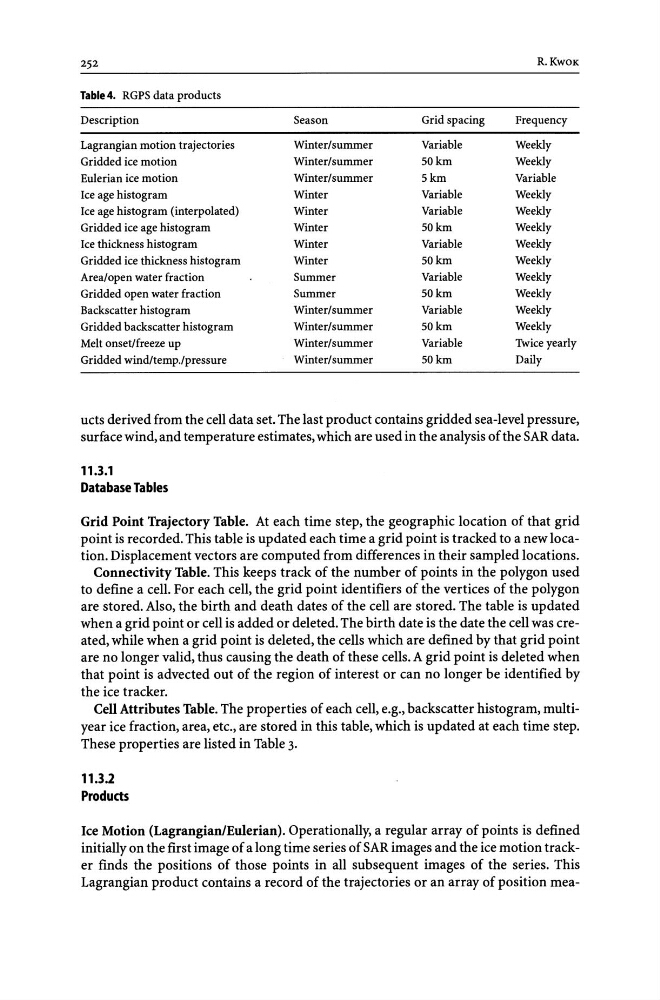
Table 4. RGPS data products
Description
Season
Grid spacing
Frequency
Lagrangian motion trajectories
Winter/summer
Variable
Weekly
Gridded ice motion
Winter/summer
SOkm
Weekly
Eulerian ice motion
Winter/summer
Skm
Variable
Ice age histogram
Winter
Variable
Weekly
Ice age histogram (interpolated)
Winter
Variable
Weekly
Gridded ice age histogram
Winter
SOkm
Weekly
Ice thickness histogram
Winter
Variable
Weekly
Gridded ice thickness histogram
Winter
SOkm
Weekly
Area/open water fraction
Summer
Variable
Weekly
Gridded open water fraction
Summer
SOkm
Weekly
Backscatter histogram
Winter/summer
Variable
Weekly
Gridded backscatter histogram
Winter/summer
SOkm
Weekly
Melt onset/freeze up
Winter/summer
Variable
Twice yearly
Gridded windltemp./pressure
Winter/summer
SOkm
Daily
ucts derived from the cell data set. The last product contains gridded sea-level pressure,
surface wind, and temperature estimates, which are used in the analysis of the SAR data.
11.3.1
Database Tables
Grid Point Trajectory Table. At each time step, the geographic location of that grid
point is recorded. This table is updated each time a grid point is tracked to a new location. Displacement vectors are computed from differences in their sampled locations.
Connectivity Table. This keeps track of the number of points in the polygon used
to define a cell. For each cell, the grid point identifiers of the vertices of the polygon
are stored. Also, the birth and death dates of the cell are stored. The table is updated
when a grid point or cell is added or deleted. The birth date is the date the cell was created, while when a grid point is deleted, the cells which are defined by that grid point
are no longer valid, thus causing the death of these cells. A grid point is deleted when
that point is advected out of the region of interest or can no longer be identified by
the ice tracker.
Cell Attributes Table. The properties of each cell, e.g., backscatter histogram, multiyear ice fraction, area, etc., are stored in this table, which is updated at each time step.
These properties are listed in Table 3.
11.3.2
Products
Ice Motion (Lagrangian/Eulerian). Operationally, a regular array of points is defined
initially on the first image of a long time series of SAR images and the ice motion tracker finds the positions of those points in all subsequent images of the series. This
Lagrangian product contains a record of the trajectories or an array of position mea-
R.KwOK
Table 4. RGPS data products
Description
Season
Grid spacing
Frequency
Lagrangian motion trajectories
Winter/summer
Variable
Weekly
Gridded ice motion
Winter/summer
SOkm
Weekly
Eulerian ice motion
Winter/summer
Skm
Variable
Ice age histogram
Winter
Variable
Weekly
Ice age histogram (interpolated)
Winter
Variable
Weekly
Gridded ice age histogram
Winter
SOkm
Weekly
Ice thickness histogram
Winter
Variable
Weekly
Gridded ice thickness histogram
Winter
SOkm
Weekly
Area/open water fraction
Summer
Variable
Weekly
Gridded open water fraction
Summer
SOkm
Weekly
Backscatter histogram
Winter/summer
Variable
Weekly
Gridded backscatter histogram
Winter/summer
SOkm
Weekly
Melt onset/freeze up
Winter/summer
Variable
Twice yearly
Gridded windltemp./pressure
Winter/summer
SOkm
Daily
ucts derived from the cell data set. The last product contains gridded sea-level pressure,
surface wind, and temperature estimates, which are used in the analysis of the SAR data.
11.3.1
Database Tables
Grid Point Trajectory Table. At each time step, the geographic location of that grid
point is recorded. This table is updated each time a grid point is tracked to a new location. Displacement vectors are computed from differences in their sampled locations.
Connectivity Table. This keeps track of the number of points in the polygon used
to define a cell. For each cell, the grid point identifiers of the vertices of the polygon
are stored. Also, the birth and death dates of the cell are stored. The table is updated
when a grid point or cell is added or deleted. The birth date is the date the cell was created, while when a grid point is deleted, the cells which are defined by that grid point
are no longer valid, thus causing the death of these cells. A grid point is deleted when
that point is advected out of the region of interest or can no longer be identified by
the ice tracker.
Cell Attributes Table. The properties of each cell, e.g., backscatter histogram, multiyear ice fraction, area, etc., are stored in this table, which is updated at each time step.
These properties are listed in Table 3.
11.3.2
Products
Ice Motion (Lagrangian/Eulerian). Operationally, a regular array of points is defined
initially on the first image of a long time series of SAR images and the ice motion tracker finds the positions of those points in all subsequent images of the series. This
Lagrangian product contains a record of the trajectories or an array of position mea-