

11 The RADARSAT Geophysical Processor System
247
I INITIALIZE I
.t TRACK NODES :
I IMAGES I
COLLECT NODE
,
AND CELL AREA
I FILL IN MISSING NODES
OR COMBINE CELLS
t
I COMPUTE CELL AREAS
,
l COMPUTE MY AREAS
,
I RECORD AVG TEMPERATURE I
DURING INTERVAL
I
I DAILY TEMPERATURE I
FIELDS
*
FORM AGE I
I
DISTRIBUTION UPDATE AREA/AGE HISTOGRAM
,
I UPDATE FREEZING I
DEGREE DAYS HISTOGRAM
. .
NO~
INCREMENT TIME STEP
STEP?
TO THICKNESS
RESOLVE INCONSISTENCIES
CONVERT
I
I
DISTRIBUTION
IN MY AREAS
,
I ADJUST FY AREA I
t
COMPUTE THICKNESS
I OUTPUT I
DISTRIBUTION
I PRODUCT
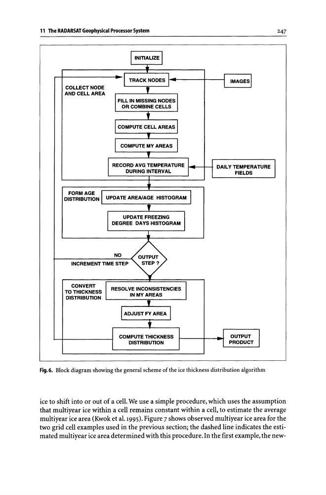
Fig.6. Block diagram showing the general scheme of the ice thickness distribution algorithm
ice to shift into or out of a cell. We use a simple procedure, which uses the assumption
that multiyear ice within a cell remains constant within a cell, to estimate the average
multiyear ice area (Kwok et al.199S). Figure 7 shows observed multiyear ice area for the
two grid cell examples used in the previous section; the dashed line indicates the estimated multiyear ice area determined with this procedure. In the first example, the new-
247
I INITIALIZE I
.t TRACK NODES :
I IMAGES I
COLLECT NODE
,
AND CELL AREA
I FILL IN MISSING NODES
OR COMBINE CELLS
t
I COMPUTE CELL AREAS
,
l COMPUTE MY AREAS
,
I RECORD AVG TEMPERATURE I
DURING INTERVAL
I
I DAILY TEMPERATURE I
FIELDS
*
FORM AGE I
I
DISTRIBUTION UPDATE AREA/AGE HISTOGRAM
,
I UPDATE FREEZING I
DEGREE DAYS HISTOGRAM
. .
NO~
INCREMENT TIME STEP
STEP?
TO THICKNESS
RESOLVE INCONSISTENCIES
CONVERT
I
I
DISTRIBUTION
IN MY AREAS
,
I ADJUST FY AREA I
t
COMPUTE THICKNESS
I OUTPUT I
DISTRIBUTION
I PRODUCT
Fig.6. Block diagram showing the general scheme of the ice thickness distribution algorithm
ice to shift into or out of a cell. We use a simple procedure, which uses the assumption
that multiyear ice within a cell remains constant within a cell, to estimate the average
multiyear ice area (Kwok et al.199S). Figure 7 shows observed multiyear ice area for the
two grid cell examples used in the previous section; the dashed line indicates the estimated multiyear ice area determined with this procedure. In the first example, the new-