

240
R.KwOK
and will not be given here. Rather, we use examples to illustrate the procedures used in
the estimation of these parameters.
11.2.1
Lagrangian Ice Motion
The ice motion tracker is based on the procedure described in Kwok et al. (1990). Briefly,
the ice tracking algorithm operates on pairs of images separated in time by n days, using
a combination of area-matching and feature-matching techniques to track an array of
points from a "source" image to a "target" image. Initially, a regular array of points is
defined on the first image of a series of images covering a region. These points constitute the corners of a regular array of square cells measuring 5 km on a side. The ice features at these points are identified and tracked in each of the subsequent images in the
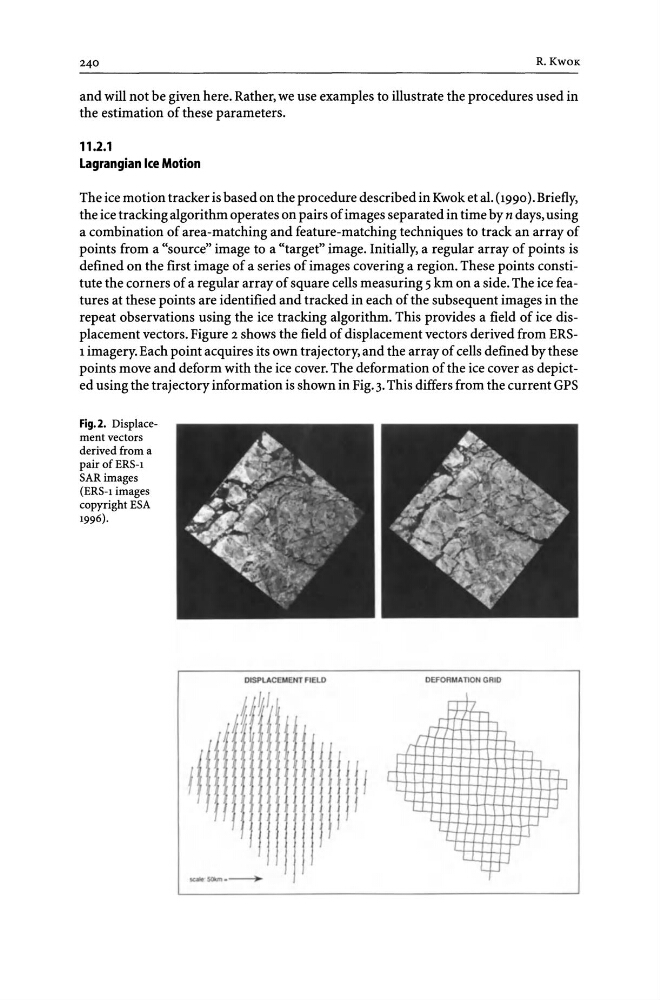
repeat observations using the ice tracking algorithm. This provides a field of ice displacement vectors. Figure 2 shows the field of displacement vectors derived from ERS1 imagery. Each point acquires its own trajectory, and the array of cells defined by these
points move and deform with the ice cover. The deformation of the ice cover as depicted using the trajectory information is shown in Fig. 3. This differs from the current GPS
Fig.2. Displacement vectors
derived from a
pair of ERS-l
SARimages
(ERS-l images
copyright ESA
1996).
DISPLACEMENT FIELD
~
DEFDRMAnON GRID
rEt
r+
l-,
R.KwOK
and will not be given here. Rather, we use examples to illustrate the procedures used in
the estimation of these parameters.
11.2.1
Lagrangian Ice Motion
The ice motion tracker is based on the procedure described in Kwok et al. (1990). Briefly,
the ice tracking algorithm operates on pairs of images separated in time by n days, using
a combination of area-matching and feature-matching techniques to track an array of
points from a "source" image to a "target" image. Initially, a regular array of points is
defined on the first image of a series of images covering a region. These points constitute the corners of a regular array of square cells measuring 5 km on a side. The ice features at these points are identified and tracked in each of the subsequent images in the
repeat observations using the ice tracking algorithm. This provides a field of ice displacement vectors. Figure 2 shows the field of displacement vectors derived from ERS1 imagery. Each point acquires its own trajectory, and the array of cells defined by these
points move and deform with the ice cover. The deformation of the ice cover as depicted using the trajectory information is shown in Fig. 3. This differs from the current GPS
Fig.2. Displacement vectors
derived from a
pair of ERS-l
SARimages
(ERS-l images
copyright ESA
1996).
DISPLACEMENT FIELD
~
DEFDRMAnON GRID
rEt
r+
l-,