

194
F. CARSEY, R. HARDING, C. WALES
approximately 82 0 north and south, and they are oriented with the SAR antenna on the
right side, which is to say with the antenna pointed north at both the northern and
southern extreme of the orbits. RADARSAT is capable of flying with the antenna on the
left side, pointing south at the orbit extrema, and there are plans to orient the spacecraft in this fashion for a few weeks in order to map Antarctica.
9.1.4
McMurdo Ground Station
In 1991 representations were made to NSF and NASA regarding the desirability of
implementing a SAR-capable ground station at Antarctica, and a Science Working
Group was appointed to look into the scientific needs and opportunities in this area;
the Group recommended that McMurdo Ground Station be implemented and indicated that the SAR data from this station would find application in studies of the dynamics and mass balance of the Antarctic ice sheet, of air-sea-ice interactions in the Ross,
Bellingshausen, and Amundsen Seas, of biological habitat in the ice-ocean environment,
and of geomorphology, tectonics, and volcanoes in exposed-rock areas (see Jezek and
Carsey 1991). In 1992, NASA and NSF agreed that it would be beneficial and feasible to
construct a ground station capable of receiving satellite SAR and other high-data-rate
signals at NSF's McMurdo Station in Antarctica.
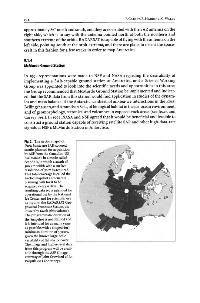
Fig.2. The Arctic Snapshot.
Dark bands are SAR-covered
swaths planned for acquisition
by ASF from the Canadian-US
RADARSAT in a mode called
ScanSAR, in which a swath of
500 km width with a surface
resolution of 50 m is acquired.
This total coverage is called the
Arctic Snapshot and current
planning calls for it to be
acquired every 6 days. The
resulting data set is intended for
operational use by the National
Ice Center and for scientific use
as input to the RADARSAT Geophysical Processor System, discussed by Kwok (this volume).
The programmatic duration of
the Snapshot is not defined and
it is intended for as many years
as possible, with a (hoped-for)
minimum duration of 5 years,
given the known large-scale
variability of the sea ice cover.
The image and higher-level data
from this program will be available through the ASF. (Image
courtesy of John Crawford of Jet
Propulsion Laboratory).
F. CARSEY, R. HARDING, C. WALES
approximately 82 0 north and south, and they are oriented with the SAR antenna on the
right side, which is to say with the antenna pointed north at both the northern and
southern extreme of the orbits. RADARSAT is capable of flying with the antenna on the
left side, pointing south at the orbit extrema, and there are plans to orient the spacecraft in this fashion for a few weeks in order to map Antarctica.
9.1.4
McMurdo Ground Station
In 1991 representations were made to NSF and NASA regarding the desirability of
implementing a SAR-capable ground station at Antarctica, and a Science Working
Group was appointed to look into the scientific needs and opportunities in this area;
the Group recommended that McMurdo Ground Station be implemented and indicated that the SAR data from this station would find application in studies of the dynamics and mass balance of the Antarctic ice sheet, of air-sea-ice interactions in the Ross,
Bellingshausen, and Amundsen Seas, of biological habitat in the ice-ocean environment,
and of geomorphology, tectonics, and volcanoes in exposed-rock areas (see Jezek and
Carsey 1991). In 1992, NASA and NSF agreed that it would be beneficial and feasible to
construct a ground station capable of receiving satellite SAR and other high-data-rate
signals at NSF's McMurdo Station in Antarctica.
Fig.2. The Arctic Snapshot.
Dark bands are SAR-covered
swaths planned for acquisition
by ASF from the Canadian-US
RADARSAT in a mode called
ScanSAR, in which a swath of
500 km width with a surface
resolution of 50 m is acquired.
This total coverage is called the
Arctic Snapshot and current
planning calls for it to be
acquired every 6 days. The
resulting data set is intended for
operational use by the National
Ice Center and for scientific use
as input to the RADARSAT Geophysical Processor System, discussed by Kwok (this volume).
The programmatic duration of
the Snapshot is not defined and
it is intended for as many years
as possible, with a (hoped-for)
minimum duration of 5 years,
given the known large-scale
variability of the sea ice cover.
The image and higher-level data
from this program will be available through the ASF. (Image
courtesy of John Crawford of Jet
Propulsion Laboratory).