

US NAVY OPERATIONAL OCEANOGRAPHY
475
for diver/swimmer mission windows; currents for underwater vehicle
operations, mine drift, and scour prediction; waves and tides for NSW small
boat and amphibious operations; currents and waves for oil/contaminant spill
prediction; and sound speed for mine and submarine detection.
Drift issues were of particular concern during operations in the Persian
Gulf both in 2003 as well as in the early 1990s. At that time, the
NAVOCEANO Shallow Water Analysis and Forecast System (Horton et al.,
1994), based on the sigma coordinate Princeton Ocean Model design of
Blumberg and Mellor (1987), provided outputs allowing both forecasts and
hindcasts of objects or substances in the water. Applied to an oil drift
problem in the Persian Gulf in the early 1990s, the SWAFS combined with
the Navy regional atmospheric prediction capability (Hodur et al., 2002) and
the NOAA oil fates code GNOME, provided guidance in protecting Saudi
desalinization facilities.
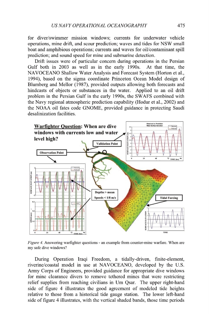
Figure 4. Answering warfighter questions - an example from counter-mine warfare. When are
my safe dive windows?
During Operation Iraqi Freedom, a tidally-driven, finite-element,
riverine/coastal model in use at NAVOCEANO, developed by the U.S.
Army Corps of Engineers, provided guidance for appropriate dive windows
for mine clearance divers to remove tethered mines that were restricting
relief supplies from reaching civilians in Um Qsar. The upper right-hand
side of figure 4 illustrates the good agreement of modeled tide heights
relative to those from a historical tide gauge station. The lower left-hand
side of figure 4 illustrates, with the vertical shaded bands, those time periods
475
for diver/swimmer mission windows; currents for underwater vehicle
operations, mine drift, and scour prediction; waves and tides for NSW small
boat and amphibious operations; currents and waves for oil/contaminant spill
prediction; and sound speed for mine and submarine detection.
Drift issues were of particular concern during operations in the Persian
Gulf both in 2003 as well as in the early 1990s. At that time, the
NAVOCEANO Shallow Water Analysis and Forecast System (Horton et al.,
1994), based on the sigma coordinate Princeton Ocean Model design of
Blumberg and Mellor (1987), provided outputs allowing both forecasts and
hindcasts of objects or substances in the water. Applied to an oil drift
problem in the Persian Gulf in the early 1990s, the SWAFS combined with
the Navy regional atmospheric prediction capability (Hodur et al., 2002) and
the NOAA oil fates code GNOME, provided guidance in protecting Saudi
desalinization facilities.
Figure 4. Answering warfighter questions - an example from counter-mine warfare. When are
my safe dive windows?
During Operation Iraqi Freedom, a tidally-driven, finite-element,
riverine/coastal model in use at NAVOCEANO, developed by the U.S.
Army Corps of Engineers, provided guidance for appropriate dive windows
for mine clearance divers to remove tethered mines that were restricting
relief supplies from reaching civilians in Um Qsar. The upper right-hand
side of figure 4 illustrates the good agreement of modeled tide heights
relative to those from a historical tide gauge station. The lower left-hand
side of figure 4 illustrates, with the vertical shaded bands, those time periods