

US NAVY OPERATIONAL OCEANOGRAPHY
471
data focused on short-term projects with special emphasis on exploring
future technologies applicable to the other departments. One such example
is the use of long-range autonomous underwater vehicles for potential
applications in order to increase hydrographic survey efficiencies. The final
three technical departments serve primarily in critical support roles to the
others.
The Survey Operations Center coordinates the use of
NAVOCEANO’s major collection assets including the seven-ship survey
fleet as well as the high-bandwidth, near-real-time ingest of survey data from
the ships. Survey Operations also coordinates both shipboard and airborne
buoy deployments including the NAVOCEANO participation in the
international ARGO drifting buoy program (Roemmich and Owens, 2000).
The Engineering Department provides support to all the sensors used on the
survey ships, coordinates the primary in-house information technology
support, and also maintains the environmental software libraries designed for
on-scene use.
Hydrography
Oceanography
Geophysics/
Acoustics
Survey
Operations
Center
Engineering
Ocean
Projects
Warfighting
Support Center
MSRC
Plans, Programs
& Requirements
•Warfare Area P.M.
•Short Term Fleet Requests
•Long Term Fleet Reqts.
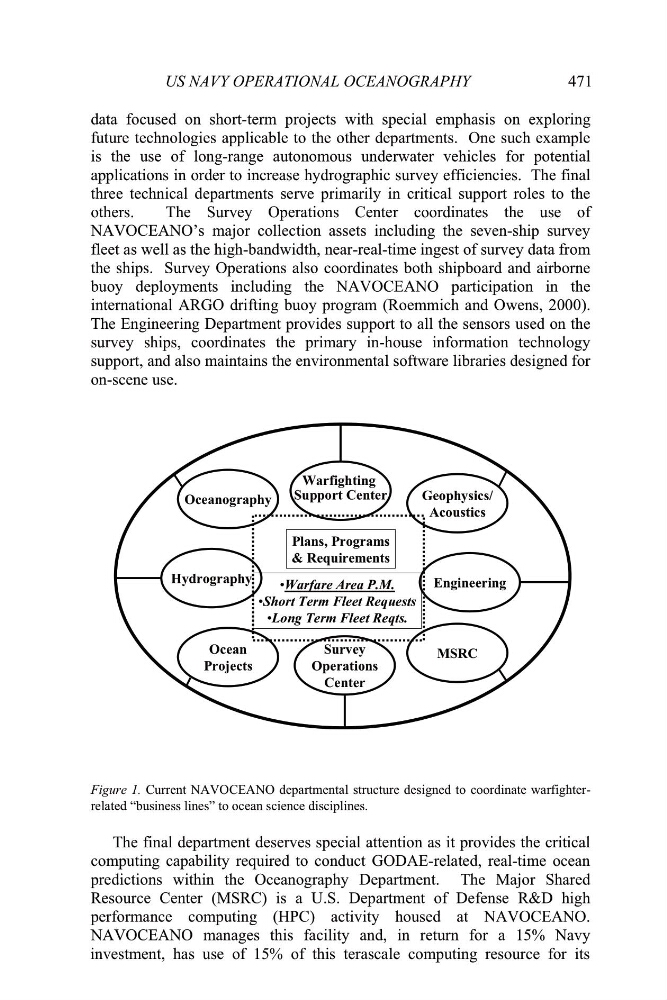
Figure 1. Current NAVOCEANO departmental structure designed to coordinate warfighterrelated “business lines” to ocean science disciplines.
The final department deserves special attention as it provides the critical
computing capability required to conduct GODAE-related, real-time ocean
predictions within the Oceanography Department. The Major Shared
Resource Center (MSRC) is a U.S. Department of Defense R&D high
performance computing (HPC) activity housed at NAVOCEANO.
NAVOCEANO manages this facility and, in return for a 15% Navy
investment, has use of 15% of this terascale computing resource for its
471
data focused on short-term projects with special emphasis on exploring
future technologies applicable to the other departments. One such example
is the use of long-range autonomous underwater vehicles for potential
applications in order to increase hydrographic survey efficiencies. The final
three technical departments serve primarily in critical support roles to the
others.
The Survey Operations Center coordinates the use of
NAVOCEANO’s major collection assets including the seven-ship survey
fleet as well as the high-bandwidth, near-real-time ingest of survey data from
the ships. Survey Operations also coordinates both shipboard and airborne
buoy deployments including the NAVOCEANO participation in the
international ARGO drifting buoy program (Roemmich and Owens, 2000).
The Engineering Department provides support to all the sensors used on the
survey ships, coordinates the primary in-house information technology
support, and also maintains the environmental software libraries designed for
on-scene use.
Hydrography
Oceanography
Geophysics/
Acoustics
Survey
Operations
Center
Engineering
Ocean
Projects
Warfighting
Support Center
MSRC
Plans, Programs
& Requirements
•Warfare Area P.M.
•Short Term Fleet Requests
•Long Term Fleet Reqts.
Figure 1. Current NAVOCEANO departmental structure designed to coordinate warfighterrelated “business lines” to ocean science disciplines.
The final department deserves special attention as it provides the critical
computing capability required to conduct GODAE-related, real-time ocean
predictions within the Oceanography Department. The Major Shared
Resource Center (MSRC) is a U.S. Department of Defense R&D high
performance computing (HPC) activity housed at NAVOCEANO.
NAVOCEANO manages this facility and, in return for a 15% Navy
investment, has use of 15% of this terascale computing resource for its