

BLUELINK
431
x Open ocean sea level from the Envisat (ESA), Jason (NASA-CNES)
and GFO (U.S. Navy) satellite altimetry (K);
x Sea surface temperatures from polar orbiting platforms and
geostationary platforms, using both infrared and microwave
instruments (SST);
x Surface wind estimates from satellite-borne instruments and
numerical weather models (W);
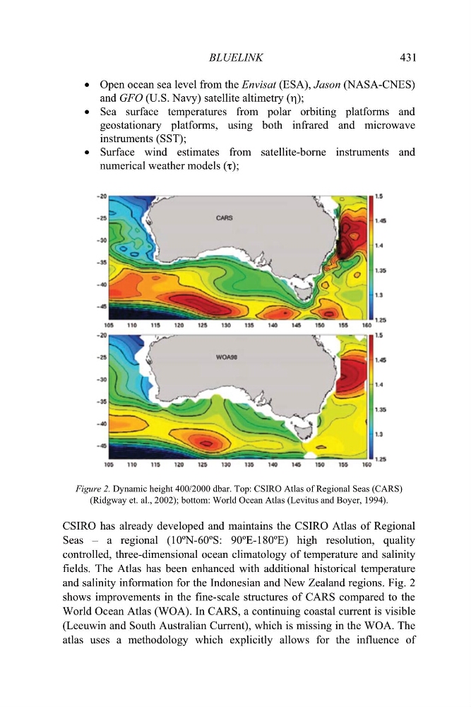
Figure 2. Dynamic height 400/2000 dbar. Top: CSIRO Atlas of Regional Seas (CARS)
(Ridgway et. al., 2002); bottom: World Ocean Atlas (Levitus and Boyer, 1994).
CSIRO has already developed and maintains the CSIRO Atlas of Regional
Seas – a regional (10ºN-60ºS: 90ºE-180ºE) high resolution, quality
controlled, three-dimensional ocean climatology of temperature and salinity
fields. The Atlas has been enhanced with additional historical temperature
and salinity information for the Indonesian and New Zealand regions. Fig. 2
shows improvements in the fine-scale structures of CARS compared to the
World Ocean Atlas (WOA). In CARS, a continuing coastal current is visible
(Leeuwin and South Australian Current), which is missing in the WOA. The
atlas uses a methodology which explicitly allows for the influence of
431
x Open ocean sea level from the Envisat (ESA), Jason (NASA-CNES)
and GFO (U.S. Navy) satellite altimetry (K);
x Sea surface temperatures from polar orbiting platforms and
geostationary platforms, using both infrared and microwave
instruments (SST);
x Surface wind estimates from satellite-borne instruments and
numerical weather models (W);
Figure 2. Dynamic height 400/2000 dbar. Top: CSIRO Atlas of Regional Seas (CARS)
(Ridgway et. al., 2002); bottom: World Ocean Atlas (Levitus and Boyer, 1994).
CSIRO has already developed and maintains the CSIRO Atlas of Regional
Seas – a regional (10ºN-60ºS: 90ºE-180ºE) high resolution, quality
controlled, three-dimensional ocean climatology of temperature and salinity
fields. The Atlas has been enhanced with additional historical temperature
and salinity information for the Indonesian and New Zealand regions. Fig. 2
shows improvements in the fine-scale structures of CARS compared to the
World Ocean Atlas (WOA). In CARS, a continuing coastal current is visible
(Leeuwin and South Australian Current), which is missing in the WOA. The
atlas uses a methodology which explicitly allows for the influence of