

DATA ASSIMILATION
331
.2.3 State reduction
Within each partition, additional vertical and horizontal approximations
are
the different regions. The barotropic component, due to its large spatial
scales, is estimated simultaneously over the entire model domain.
5
defined to further reduce the errors’ dimension. Vertically, state errors
are expanded in terms of vertical dynamic modes of velocity and vertical
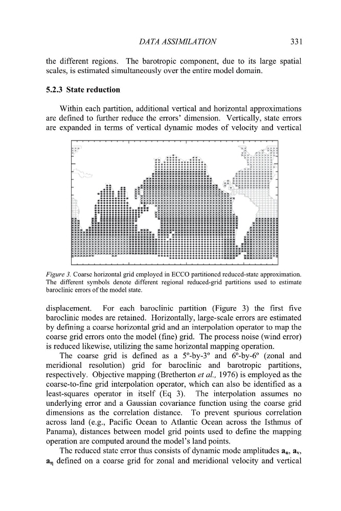
. Coarse horizontal grid employed in ECCO partitioned reduced-state approximation.
isplacement. For each baroclinic partition (Figure 3) the first five
l and
mer
amplitudes a u , a v ,
a K defined on a coarse grid for zonal and meridional velocity and vertical
Figure 3
The different symbols denote different regional reduced-grid partitions used to estimate
baroclinic errors of the model state.
d
baroclinic modes are retained. Horizontally, large-scale errors are estimated
by defining a coarse horizontal grid and an interpolation operator to map the
coarse grid errors onto the model (fine) grid. The process noise (wind error)
is reduced likewise, utilizing the same horizontal mapping operation.
The coarse grid is defined as a 5º-by-3º and 6º-by-6º (zona
idional resolution) grid for baroclinic and barotropic partitions,
respectively. Objective mapping (Bretherton et al., 1976) is employed as the
coarse-to-fine grid interpolation operator, which can also be identified as a
least-squares operator in itself (Eq 3). The interpolation assumes no
underlying error and a Gaussian covariance function using the coarse grid
dimensions as the correlation distance. To prevent spurious correlation
across land (e.g., Pacific Ocean to Atlantic Ocean across the Isthmus of
Panama), distances between model grid points used to define the mapping
operation are computed around the model’s land points.
The reduced state error thus consists of dynamic mode
331
.2.3 State reduction
Within each partition, additional vertical and horizontal approximations
are
the different regions. The barotropic component, due to its large spatial
scales, is estimated simultaneously over the entire model domain.
5
defined to further reduce the errors’ dimension. Vertically, state errors
are expanded in terms of vertical dynamic modes of velocity and vertical
. Coarse horizontal grid employed in ECCO partitioned reduced-state approximation.
isplacement. For each baroclinic partition (Figure 3) the first five
l and
mer
amplitudes a u , a v ,
a K defined on a coarse grid for zonal and meridional velocity and vertical
Figure 3
The different symbols denote different regional reduced-grid partitions used to estimate
baroclinic errors of the model state.
d
baroclinic modes are retained. Horizontally, large-scale errors are estimated
by defining a coarse horizontal grid and an interpolation operator to map the
coarse grid errors onto the model (fine) grid. The process noise (wind error)
is reduced likewise, utilizing the same horizontal mapping operation.
The coarse grid is defined as a 5º-by-3º and 6º-by-6º (zona
idional resolution) grid for baroclinic and barotropic partitions,
respectively. Objective mapping (Bretherton et al., 1976) is employed as the
coarse-to-fine grid interpolation operator, which can also be identified as a
least-squares operator in itself (Eq 3). The interpolation assumes no
underlying error and a Gaussian covariance function using the coarse grid
dimensions as the correlation distance. To prevent spurious correlation
across land (e.g., Pacific Ocean to Atlantic Ocean across the Isthmus of
Panama), distances between model grid points used to define the mapping
operation are computed around the model’s land points.
The reduced state error thus consists of dynamic mode