

SATELLITE MEASUREMENTS
157
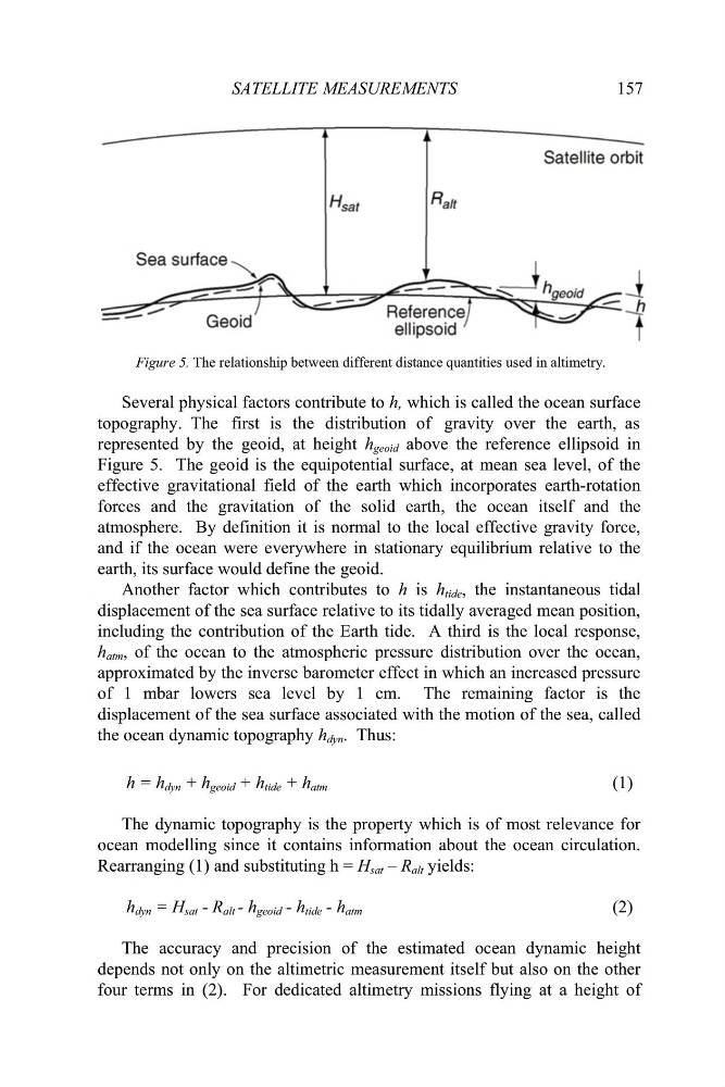
Figure 5. The relationship between different distance quantities used in altimetry.
Several physical factors contribute to h, which is called the ocean surface
topography. The first is the distribution of gravity over the earth, as
represented by the geoid, at height h geoid above the reference ellipsoid in
Figure 5. The geoid is the equipotential surface, at mean sea level, of the
effective gravitational field of the earth which incorporates earth-rotation
forces and the gravitation of the solid earth, the ocean itself and the
atmosphere. By definition it is normal to the local effective gravity force,
and if the ocean were everywhere in stationary equilibrium relative to the
earth, its surface would define the geoid.
Another factor which contributes to h is h tide , the instantaneous tidal
displacement of the sea surface relative to its tidally averaged mean position,
including the contribution of the Earth tide. A third is the local response,
h atm , of the ocean to the atmospheric pressure distribution over the ocean,
approximated by the inverse barometer effect in which an increased pressure
of 1 mbar lowers sea level by 1 cm. The remaining factor is the
displacement of the sea surface associated with the motion of the sea, called
the ocean dynamic topography h dyn . Thus:
h = h dyn + h geoid + h tide + h atm
(1)
The dynamic topography is the property which is of most relevance for
ocean modelling since it contains information about the ocean circulation.
Rearranging (1) and substituting h = H sat – R alt yields:
h dyn = H sat - R alt - h geoid - h tide - h atm
(2)
The accuracy and precision of the estimated ocean dynamic height
depends not only on the altimetric measurement itself but also on the other
four terms in (2). For dedicated altimetry missions flying at a height of
157
Figure 5. The relationship between different distance quantities used in altimetry.
Several physical factors contribute to h, which is called the ocean surface
topography. The first is the distribution of gravity over the earth, as
represented by the geoid, at height h geoid above the reference ellipsoid in
Figure 5. The geoid is the equipotential surface, at mean sea level, of the
effective gravitational field of the earth which incorporates earth-rotation
forces and the gravitation of the solid earth, the ocean itself and the
atmosphere. By definition it is normal to the local effective gravity force,
and if the ocean were everywhere in stationary equilibrium relative to the
earth, its surface would define the geoid.
Another factor which contributes to h is h tide , the instantaneous tidal
displacement of the sea surface relative to its tidally averaged mean position,
including the contribution of the Earth tide. A third is the local response,
h atm , of the ocean to the atmospheric pressure distribution over the ocean,
approximated by the inverse barometer effect in which an increased pressure
of 1 mbar lowers sea level by 1 cm. The remaining factor is the
displacement of the sea surface associated with the motion of the sea, called
the ocean dynamic topography h dyn . Thus:
h = h dyn + h geoid + h tide + h atm
(1)
The dynamic topography is the property which is of most relevance for
ocean modelling since it contains information about the ocean circulation.
Rearranging (1) and substituting h = H sat – R alt yields:
h dyn = H sat - R alt - h geoid - h tide - h atm
(2)
The accuracy and precision of the estimated ocean dynamic height
depends not only on the altimetric measurement itself but also on the other
four terms in (2). For dedicated altimetry missions flying at a height of