

154
IAN ROBINSON
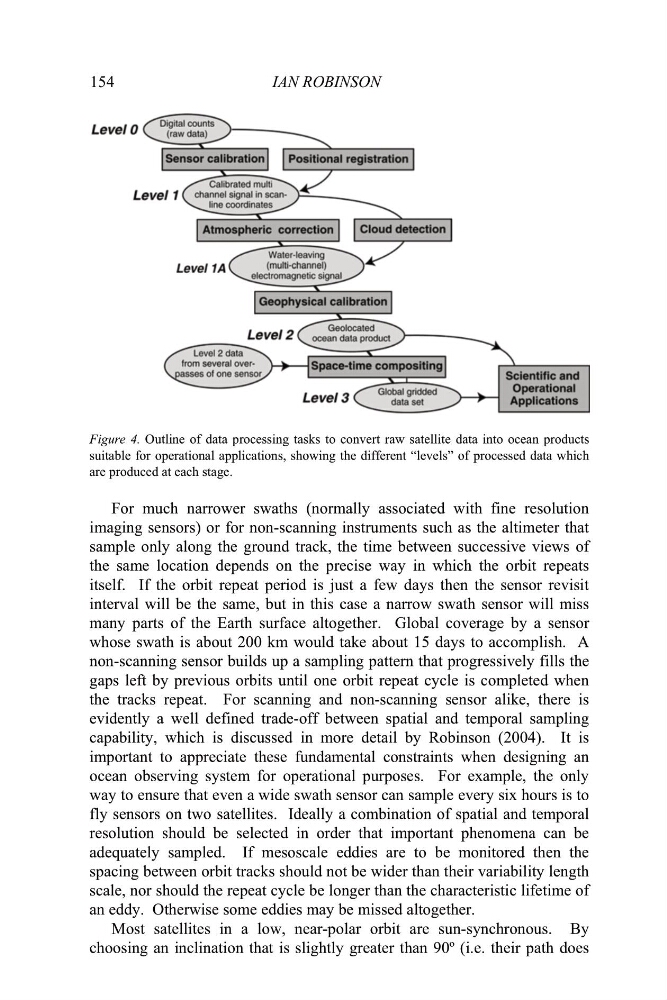
Figure 4. Outline of data processing tasks to convert raw satellite data into ocean products
suitable for operational applications, showing the different “levels” of processed data which
are produced at each stage.
For much narrower swaths (normally associated with fine resolution
imaging sensors) or for non-scanning instruments such as the altimeter that
sample only along the ground track, the time between successive views of
the same location depends on the precise way in which the orbit repeats
itself. If the orbit repeat period is just a few days then the sensor revisit
interval will be the same, but in this case a narrow swath sensor will miss
many parts of the Earth surface altogether. Global coverage by a sensor
whose swath is about 200 km would take about 15 days to accomplish. A
non-scanning sensor builds up a sampling pattern that progressively fills the
gaps left by previous orbits until one orbit repeat cycle is completed when
the tracks repeat. For scanning and non-scanning sensor alike, there is
evidently a well defined trade-off between spatial and temporal sampling
capability, which is discussed in more detail by Robinson (2004). It is
important to appreciate these fundamental constraints when designing an
ocean observing system for operational purposes. For example, the only
way to ensure that even a wide swath sensor can sample every six hours is to
fly sensors on two satellites. Ideally a combination of spatial and temporal
resolution should be selected in order that important phenomena can be
adequately sampled. If mesoscale eddies are to be monitored then the
spacing between orbit tracks should not be wider than their variability length
scale, nor should the repeat cycle be longer than the characteristic lifetime of
an eddy. Otherwise some eddies may be missed altogether.
Most satellites in a low, near-polar orbit are sun-synchronous. By
choosing an inclination that is slightly greater than 90º (i.e. their path does
IAN ROBINSON
Figure 4. Outline of data processing tasks to convert raw satellite data into ocean products
suitable for operational applications, showing the different “levels” of processed data which
are produced at each stage.
For much narrower swaths (normally associated with fine resolution
imaging sensors) or for non-scanning instruments such as the altimeter that
sample only along the ground track, the time between successive views of
the same location depends on the precise way in which the orbit repeats
itself. If the orbit repeat period is just a few days then the sensor revisit
interval will be the same, but in this case a narrow swath sensor will miss
many parts of the Earth surface altogether. Global coverage by a sensor
whose swath is about 200 km would take about 15 days to accomplish. A
non-scanning sensor builds up a sampling pattern that progressively fills the
gaps left by previous orbits until one orbit repeat cycle is completed when
the tracks repeat. For scanning and non-scanning sensor alike, there is
evidently a well defined trade-off between spatial and temporal sampling
capability, which is discussed in more detail by Robinson (2004). It is
important to appreciate these fundamental constraints when designing an
ocean observing system for operational purposes. For example, the only
way to ensure that even a wide swath sensor can sample every six hours is to
fly sensors on two satellites. Ideally a combination of spatial and temporal
resolution should be selected in order that important phenomena can be
adequately sampled. If mesoscale eddies are to be monitored then the
spacing between orbit tracks should not be wider than their variability length
scale, nor should the repeat cycle be longer than the characteristic lifetime of
an eddy. Otherwise some eddies may be missed altogether.
Most satellites in a low, near-polar orbit are sun-synchronous. By
choosing an inclination that is slightly greater than 90º (i.e. their path does