

4.4 Exercise 6: The Flooding Algorithm
79
4.4.2 Redefinitio of Wet and Dry
From now on, wet grid cells are define as cells of total water depths h exceeding
a certain threshold value, h min , typically set to a few centimetres. This threshold
is required to avoid that flui retreating from a wet region produces negative layer
thicknesses that will cause the model to crash. Accordingly, dry grid cells are define
as cells where h ≤ h min .
4.4.3 Enabling Flooding of Dry Grid Cells
Flooding of dry grid cells is implemented in the code via calculation of the horizontal speed at the interface between wet and dry grid cells. This calculation is
performed whenever the pressure-gradient force is directed toward the dry cell.
Otherwise, velocity at this grid point is kept at zero value. With a nonzero infl w,
the water level in the dry cell will rise and this cells eventually turns into a wet grid
cell once the layer thickness exceeds h min .
4.4.4 Flooding of Sloping Beaches
The pressure-gradient force is evaluated from the slope of the sea-level elevation
with respect to an undisturbed state. Flooding of a sloping beach has to be treated
the same way. Here, the sea-level elevation has to be define as the distance of the
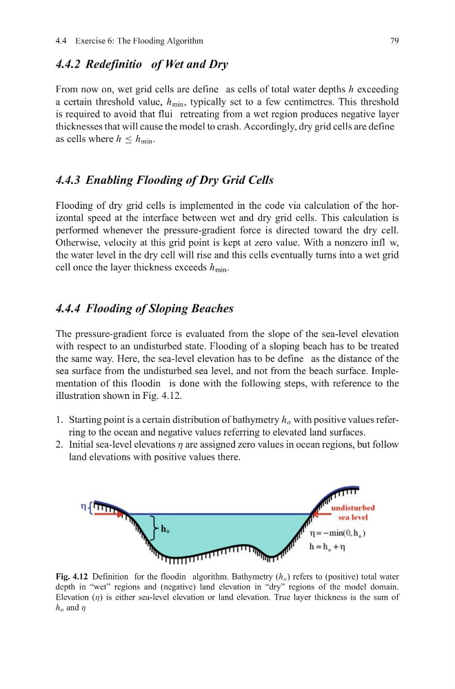
sea surface from the undisturbed sea level, and not from the beach surface. Implementation of this floodin is done with the following steps, with reference to the
illustration shown in Fig. 4.12.
1. Starting point is a certain distribution of bathymetry h o with positive values referring to the ocean and negative values referring to elevated land surfaces.
2. Initial sea-level elevations η are assigned zero values in ocean regions, but follow
land elevations with positive values there.
Fig. 4.12 Definition for the floodin algorithm. Bathymetry (h o ) refers to (positive) total water
depth in “wet” regions and (negative) land elevation in “dry” regions of the model domain.
Elevation (η) is either sea-level elevation or land elevation. True layer thickness is the sum of
h o and η
79
4.4.2 Redefinitio of Wet and Dry
From now on, wet grid cells are define as cells of total water depths h exceeding
a certain threshold value, h min , typically set to a few centimetres. This threshold
is required to avoid that flui retreating from a wet region produces negative layer
thicknesses that will cause the model to crash. Accordingly, dry grid cells are define
as cells where h ≤ h min .
4.4.3 Enabling Flooding of Dry Grid Cells
Flooding of dry grid cells is implemented in the code via calculation of the horizontal speed at the interface between wet and dry grid cells. This calculation is
performed whenever the pressure-gradient force is directed toward the dry cell.
Otherwise, velocity at this grid point is kept at zero value. With a nonzero infl w,
the water level in the dry cell will rise and this cells eventually turns into a wet grid
cell once the layer thickness exceeds h min .
4.4.4 Flooding of Sloping Beaches
The pressure-gradient force is evaluated from the slope of the sea-level elevation
with respect to an undisturbed state. Flooding of a sloping beach has to be treated
the same way. Here, the sea-level elevation has to be define as the distance of the
sea surface from the undisturbed sea level, and not from the beach surface. Implementation of this floodin is done with the following steps, with reference to the
illustration shown in Fig. 4.12.
1. Starting point is a certain distribution of bathymetry h o with positive values referring to the ocean and negative values referring to elevated land surfaces.
2. Initial sea-level elevations η are assigned zero values in ocean regions, but follow
land elevations with positive values there.
Fig. 4.12 Definition for the floodin algorithm. Bathymetry (h o ) refers to (positive) total water
depth in “wet” regions and (negative) land elevation in “dry” regions of the model domain.
Elevation (η) is either sea-level elevation or land elevation. True layer thickness is the sum of
h o and η