

made further observations impossible. The explosion forced the divers to leave the
site and get to the sea’s surface as quickly they could.
On the surface, the ship’s hull was vibrating with a deep sound and volcanic
ejecta (pyroclasts) were observed falling all around. The sea’s surface was glowing
with red gases, caused by the burning H 2 and colored by the high-temperature
oxidation of FeO to Fe 2 O 3 , which was included in the volcanic ash. The smell of
‘‘rotten eggs’’ caused by hydrogen sulfide vapors was noted, especially during
episodes of intense turbulence in the water. There were steam bursts and gas discharge. Also, there was a green discoloration on the water surface that spread over
an area of at least one nautical mile in diameter (Cheminée et al. 1988). Water was
sampled and for the first time, the presence of hyperthermophile archaebacteria,
which could live at relatively high (80 °C) temperature within the crater of an
erupting volcano, was revealed (Huber et al. 1990).
Several days later, the ship’s hull vibrated with a deep sound that meant the
Macdonald volcano was erupting once again underneath the vessel. Over a total of
five days of eruption, gas and volcanic ashes were observed glowing on the sea’s
surface and dead fish were seen floating with their bellies up, or on their sides. The
total length of each eruption lasted only few hours. If such an eruption had continued for a longer period, an island could have emerged on the water’s surface,
thereby endangering the vessel.
Pitcairn Hotspot
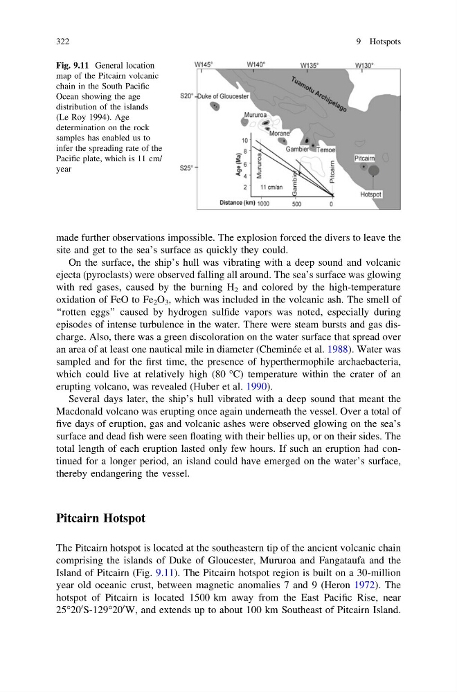
The Pitcairn hotspot is located at the southeastern tip of the ancient volcanic chain
comprising the islands of Duke of Gloucester, Mururoa and Fangataufa and the
Island of Pitcairn (Fig. 9.11). The Pitcairn hotspot region is built on a 30-million
year old oceanic crust, between magnetic anomalies 7 and 9 (Heron 1972). The
hotspot of Pitcairn is located 1500 km away from the East Pacific Rise, near
25°20
0 S-129°20
0 W, and extends up to about 100 km Southeast of Pitcairn Island.
Fig. 9.11 General location
map of the Pitcairn volcanic
chain in the South Pacific
Ocean showing the age
distribution of the islands
(Le Roy 1994). Age
determination on the rock
samples has enabled us to
infer the spreading rate of the
Pacific plate, which is 11 cm/
year
322
9 Hotspots
site and get to the sea’s surface as quickly they could.
On the surface, the ship’s hull was vibrating with a deep sound and volcanic
ejecta (pyroclasts) were observed falling all around. The sea’s surface was glowing
with red gases, caused by the burning H 2 and colored by the high-temperature
oxidation of FeO to Fe 2 O 3 , which was included in the volcanic ash. The smell of
‘‘rotten eggs’’ caused by hydrogen sulfide vapors was noted, especially during
episodes of intense turbulence in the water. There were steam bursts and gas discharge. Also, there was a green discoloration on the water surface that spread over
an area of at least one nautical mile in diameter (Cheminée et al. 1988). Water was
sampled and for the first time, the presence of hyperthermophile archaebacteria,
which could live at relatively high (80 °C) temperature within the crater of an
erupting volcano, was revealed (Huber et al. 1990).
Several days later, the ship’s hull vibrated with a deep sound that meant the
Macdonald volcano was erupting once again underneath the vessel. Over a total of
five days of eruption, gas and volcanic ashes were observed glowing on the sea’s
surface and dead fish were seen floating with their bellies up, or on their sides. The
total length of each eruption lasted only few hours. If such an eruption had continued for a longer period, an island could have emerged on the water’s surface,
thereby endangering the vessel.
Pitcairn Hotspot
The Pitcairn hotspot is located at the southeastern tip of the ancient volcanic chain
comprising the islands of Duke of Gloucester, Mururoa and Fangataufa and the
Island of Pitcairn (Fig. 9.11). The Pitcairn hotspot region is built on a 30-million
year old oceanic crust, between magnetic anomalies 7 and 9 (Heron 1972). The
hotspot of Pitcairn is located 1500 km away from the East Pacific Rise, near
25°20
0 S-129°20
0 W, and extends up to about 100 km Southeast of Pitcairn Island.
Fig. 9.11 General location
map of the Pitcairn volcanic
chain in the South Pacific
Ocean showing the age
distribution of the islands
(Le Roy 1994). Age
determination on the rock
samples has enabled us to
infer the spreading rate of the
Pacific plate, which is 11 cm/
year
322
9 Hotspots