

The Northeastern seamount near 12°50
0 N-102°53
0 W was visited during a dive
in order to find hydrothermal deposits. The seamount had the same shape as the
Southeastern seamount where extensive sulfide deposits had been found, so I
thought that this would also be the case for this seamount. However, dive Cy84-28
made by Yves Fouquet, as the scientific observer, with Arnoux and Nivagioli as
the pilot and engineer, failed to see any hydrothermal activity. This dive started at
the foot of the seamount and never reached the top. Nevertheless, my intuition to
dive on the Northeastern seamount was revealed to be correct because a couple
years later, during another expedition conducted by Yves Fouquet, hydrothermal
activity in the form of ‘‘black smokers’’ was indeed found on the top of this
seamount.
Another of these seamounts, called the Southeastern Seamount, revealed the
presence of large deposits of metallic sulfides. A dredge was lowered early in the
morning on May 17, 1981, at 07h07 on the southern flank of the seamount that we
named the Southeastern Seamount. The dredge recovered 700 k of massive
metallic sulfides from a depth of 2,100 m. When the dredge was pulled up by the
crane and emptied on the back deck, we had an unexpected surprise. Golden
colored crystals of the pyrite rich material were shining on the deck of the ship, to
the astonishment of the scientists and the crew. In addition to the massive Fe-rich
sulfides, hydrated and oxidized iron and massive silica-rich hydrothermal material
was lying in front of us (see Chap. 6). The presence of metallic sulfides on an offaxial seamount was an important discovery and opened a new horizon for looking
at metal ore deposits on the sea floor.
Returning to the site the following year, in 1982, during the Geocyatherm
cruise with the submersible Cyana, we had confirmation of our findings. However,
it was only in 1984 during the Geocyarise Leg 3 that we were able to do a detailed
survey, almost as a mining geologist would have done on land. Jim Franklin, a
mining specialist, was the best qualified to conduct this survey and I was eager to
have his input. I was anxious all day waiting for him to come back to the surface
and tell us what he thought about the site. Finally, at 6 PM the chief of the
submersible group gave the order for Cyana to start to come back up. It was only at
about 7:30 PM that Jim Franklin could give us a briefing after getting out from the
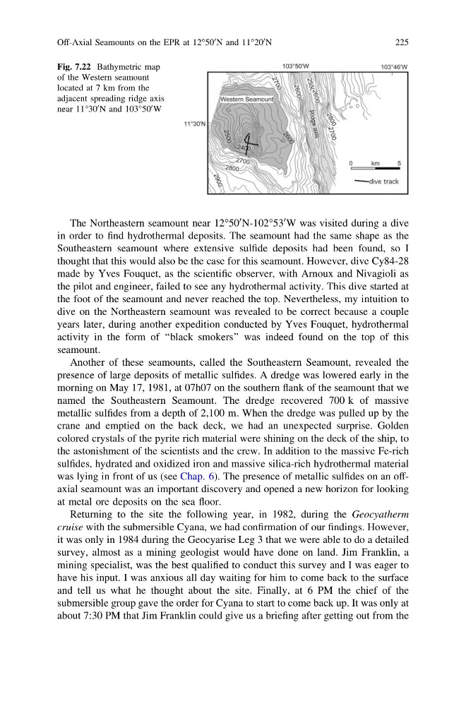
Fig. 7.22 Bathymetric map
of the Western seamount
located at 7 km from the
adjacent spreading ridge axis
near 11°30
0 N and 103°50
0 W
Off-Axial Seamounts on the EPR at 12°50
0 N and 11°20
0 N
225
0 N-102°53
0 W was visited during a dive
in order to find hydrothermal deposits. The seamount had the same shape as the
Southeastern seamount where extensive sulfide deposits had been found, so I
thought that this would also be the case for this seamount. However, dive Cy84-28
made by Yves Fouquet, as the scientific observer, with Arnoux and Nivagioli as
the pilot and engineer, failed to see any hydrothermal activity. This dive started at
the foot of the seamount and never reached the top. Nevertheless, my intuition to
dive on the Northeastern seamount was revealed to be correct because a couple
years later, during another expedition conducted by Yves Fouquet, hydrothermal
activity in the form of ‘‘black smokers’’ was indeed found on the top of this
seamount.
Another of these seamounts, called the Southeastern Seamount, revealed the
presence of large deposits of metallic sulfides. A dredge was lowered early in the
morning on May 17, 1981, at 07h07 on the southern flank of the seamount that we
named the Southeastern Seamount. The dredge recovered 700 k of massive
metallic sulfides from a depth of 2,100 m. When the dredge was pulled up by the
crane and emptied on the back deck, we had an unexpected surprise. Golden
colored crystals of the pyrite rich material were shining on the deck of the ship, to
the astonishment of the scientists and the crew. In addition to the massive Fe-rich
sulfides, hydrated and oxidized iron and massive silica-rich hydrothermal material
was lying in front of us (see Chap. 6). The presence of metallic sulfides on an offaxial seamount was an important discovery and opened a new horizon for looking
at metal ore deposits on the sea floor.
Returning to the site the following year, in 1982, during the Geocyatherm
cruise with the submersible Cyana, we had confirmation of our findings. However,
it was only in 1984 during the Geocyarise Leg 3 that we were able to do a detailed
survey, almost as a mining geologist would have done on land. Jim Franklin, a
mining specialist, was the best qualified to conduct this survey and I was eager to
have his input. I was anxious all day waiting for him to come back to the surface
and tell us what he thought about the site. Finally, at 6 PM the chief of the
submersible group gave the order for Cyana to start to come back up. It was only at
about 7:30 PM that Jim Franklin could give us a briefing after getting out from the
Fig. 7.22 Bathymetric map
of the Western seamount
located at 7 km from the
adjacent spreading ridge axis
near 11°30
0 N and 103°50
0 W
Off-Axial Seamounts on the EPR at 12°50
0 N and 11°20
0 N
225