

The East Pacific Rise
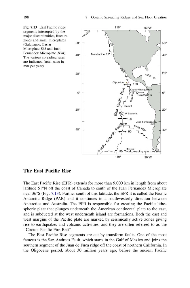
The East Pacific Rise (EPR) extends for more than 9,000 km in length from about
latitude 51°N off the coast of Canada to south of the Juan Fernandez Microplate
near 36°S (Fig. 7.13). Further south of this latitude, the EPR it is called the Pacific
Antarctic Ridge (PAR) and it continues in a southwesterly direction between
Antarctica and Australia. The EPR is responsible for creating the Pacific lithospheric plate that plunges underneath the American continental plate to the east,
and is subducted at the west underneath island arc formations. Both the east and
west margins of the Pacific plate are marked by seismically active zones giving
rise to earthquakes and volcanic activities, and they are often referred to as the
‘‘Circum-Pacific Fire Belt’’.
The East Pacific Rise segments are cut by transform faults. One of the most
famous is the San Andreas Fault, which starts in the Gulf of Mexico and joins the
southern segment of the Juan de Fuca ridge off the coast of northern California. In
the Oligocene period, about 30 million years ago, before the ancient Pacific
50°
0°
20°
20°
40°
90°W
110°
90°W
110°
Clipperton
Galapagos Is.
Easter Is.
Garrett
40°
50°
0°
20°
20°
40°
40°
E a s t P a c if ic R is e
P a c i f i c
A n t a r c t i c
R i d g e
Mendocino F.Z.
C h il e R is e
Juan Fernandez Is.
EM
JFM
Cocos-Nazca Ridge
160
90
120
90, Total preading rate mm/year
He ss De ep
Fig. 7.13 East Pacific ridge
segments interrupted by the
major discontinuities, fracture
zones and small microplates
(Galapagos, Easter
Microplate EM and Juan
Fernandez Microplate JFM).
The various spreading rates
are indicated (total rates in
mm per year)
198
7 Oceanic Spreading Ridges and Sea Floor Creation
The East Pacific Rise (EPR) extends for more than 9,000 km in length from about
latitude 51°N off the coast of Canada to south of the Juan Fernandez Microplate
near 36°S (Fig. 7.13). Further south of this latitude, the EPR it is called the Pacific
Antarctic Ridge (PAR) and it continues in a southwesterly direction between
Antarctica and Australia. The EPR is responsible for creating the Pacific lithospheric plate that plunges underneath the American continental plate to the east,
and is subducted at the west underneath island arc formations. Both the east and
west margins of the Pacific plate are marked by seismically active zones giving
rise to earthquakes and volcanic activities, and they are often referred to as the
‘‘Circum-Pacific Fire Belt’’.
The East Pacific Rise segments are cut by transform faults. One of the most
famous is the San Andreas Fault, which starts in the Gulf of Mexico and joins the
southern segment of the Juan de Fuca ridge off the coast of northern California. In
the Oligocene period, about 30 million years ago, before the ancient Pacific
50°
0°
20°
20°
40°
90°W
110°
90°W
110°
Clipperton
Galapagos Is.
Easter Is.
Garrett
40°
50°
0°
20°
20°
40°
40°
E a s t P a c if ic R is e
P a c i f i c
A n t a r c t i c
R i d g e
Mendocino F.Z.
C h il e R is e
Juan Fernandez Is.
EM
JFM
Cocos-Nazca Ridge
160
90
120
90, Total preading rate mm/year
He ss De ep
Fig. 7.13 East Pacific ridge
segments interrupted by the
major discontinuities, fracture
zones and small microplates
(Galapagos, Easter
Microplate EM and Juan
Fernandez Microplate JFM).
The various spreading rates
are indicated (total rates in
mm per year)
198
7 Oceanic Spreading Ridges and Sea Floor Creation